 |
      |
| Home > California > Jawbone Canyon |
Jawbone Canyon
Saturday, May 10, 2025
| Other Names | East Kern County, Grass Valley Wilderness, Mojave Desert, Red Rock, Cantil, Jawbone OHV Area, Jawbone To Lake Isabella, Jawbone Station / Randsburg, Rand Mountain, Isabella Lake, Jawbone Canyon OHV |
| Last Known Status | Open |
This canyon is littered with steep and challenging hill climbs that require a big four-stroke or 500cc two-stroke to make it to the top consistently. The valley floor has some deep sandy washes and trails that form long loops but the most interesting routes require a few good hill climbs.
There are plenty of spots to park and camp but there are no RV hookups or shade in the area. Sometimes during the evening, violent canyon winds may kick up and can do a pretty good job of shaking RV's and trailers.
The visitor center at the entrance has maps and guide books for all of the surrounding area. A quarter mile to the south is the Jawbone Canyon Store which carries basic groceries, firewood, ice, propane and gasoline. Live bands usually play here during holiday weekends, and ATV rentals are located next door.
REGULATIONS
| Permit Required | Yes | CA OHMVR stickers required |
| Dates Open | Year-Round | CA OHMVR red sticker vehicles permitted from 9/1 to 5/31 |
| Other ATV Stickers Accepted | Yes | Residents of any state not listed must purchase a Nonresident OHV Use Permit. (AR, AZ, CA, CO, CT, DE, IA, ID, IN, LA, MA, MD, ME, MI, MN, MO, MT, ND, NH, NJ, NM, NV, NY, OH, OK, OR, PA, RI, TX, UT, VT, WA, WI, WY) |
| Spark Arrestor | Yes | A spark arresting exhaust silencer or end cap is required for all vehicles. |
| Noise Limit | Yes (96 dB) | CA OHMVR noise limits apply (1985/older limit 101 dB, 1986/newer limit 96 dB) |
| Whip Flags | Not Required | |
| Maximum Vehicle Width | No Restriction | |
 Motorcycles & Dirt Bikes Motorcycles & Dirt Bikes | Permitted | CA OHMVR stickers required |
 ATVs ATVs | Permitted | CA OHMVR stickers required |
 UTV & SXS UTV & SXS | Permitted | CA OHMVR stickers required |
 SUVs & Jeeps (registered) SUVs & Jeeps (registered) | Permitted | |
| Dune Buggy & Sand Rail 4x4 (unregistered) | Permitted | CA OHMVR stickers required |
| 2 Stroke Engines | Certain Times | CA OHMVR restrictions apply |
| MX Helmet Required | Yes | helmets required by state law |
 Camping Camping | No Restriction | (camp anywhere) |
 Campfires Campfires | No Restriction | burn season laws apply - conditions can get very windy |
| Night Riding | Unknown | |
| Trail Blazing | Prohibited | keep on designated trails |
| Alcohol | No Restriction | |
| Rule Enforcement |
TERRAIN
| Approx Size | 8,500 acres (13 sq mi) | |
| Miles Of Trail | 100 | |
| Climate Type | Desert | |
| Elevation | 2100 to 4500 ft. | |
| Trail Maintenance | Not Marked, Not Rated, Not Maintained | |
| Loose Dirt |  Little Little | |
| Hard Pack |  Some Some | |
| Sand |  Mostly Mostly | |
| Mud |  None None | |
| Dust | Mostly | |
| Rocks | Mostly | |
| Trees |  Few Few | |
| Steep Hills |  Many Many | very steep hill climbs - experts only |
| Water Crossings | Few | some dry creek crossings |
| Small Jumps | Few | |
| Large Jumps | Few | |
| Berms | Few | |
| Sand/Gravel Pits | Few | some mining mounds that are quite large |
| Single Track | Some | |
| Roads | Some | |
| Intersections | Many | |
| Rider Traffic | Some | |
| Shade | None | |
| Ranges/Gunfire | Some | |
| Hazards | Few | (hazards not marked) |
 Novice Novice | Little | |
 Amateur Amateur | Some | |
 Expert Expert | Mostly | |
| Comment | Main canyon consists of mostly extremely steep hill climbs - experts only. Novice riders can stick to valley floor - deep sand. | |
TYPE OF AREA
| Area | Motorized Trails, Gravel Pit, some gravel mounds created by mining |
| Land | BLM |


KEY SERVICES
 Gasoline Gasoline | On Site | Jawbone Canyon Store (866) 346-6274 |
| Diesel | 5-20 Miles (S) | Faststop Food Store (760) 373-1212 |
 Water Water | On Site | Jawbone Canyon Store (866) 346-6274 |
 RV Hookup RV Hookup | 5-20 Miles (S) | Sierra Trails RV Park (877) 994-7999 |
 RV Disposal RV Disposal | 5-20 Miles (N) | Redrock Canyon Ricardo Campground (661) 942-0662 ($20 to dump, payable by debit or credit card only) |
| Campground | On Site | primitve camping permitted |
 Conv Store Conv Store | On Site | Jawbone Canyon Store (866) 346-6274 |
FEES & PASSES
| Parking | (None) |
| Entry | (None) |
| Riding | (None) |
| Camping | (None) |
RATINGS
| Pros | challenging hill climbs, good variety, lots of trails organized, good services at entrance including gas, food, parts, repair, etc |
| Cons | windy, dry & hot desert! |
| Our Rating |  Excellent Excellent |
| Recommended Stay | 3-5 Days |
| Comments | (Scroll Down For Rider Reviews & Comments) |
DRIVING DIRECTIONS
| Nearest City | Cantil, CA | ||
| Address | Jawbone Canyon Road, Cantil, CA 93519 | ||
| From: Los Angeles, CA
1) Take Hwy 14 North about 70 miles to Cantil 2) Turn left (west) onto Jawbone Canyon Road, continue about 4 miles 3) Stage anywhere. |


OFFICIAL CONTACTS
| Contact Info | BLM - Ridgecrest Field Office 300 S. Richmond Road Ridgecrest, CA 93555 (760) 384-5400 blm_ca_web_ri@blm.gov www.blm.gov |
| Contact Info | Friends of Jawbone Canyon P.O. Box 1902 Cantil, CA 93519 (760) 373-1146 webmaster@jawbone.org www.jawbone.org |
| Contact Info | Jawbone Canyon Store 32629 Highway 14 Cantil, CA 93519 (760) 373-2773 (866) 346-6274 info@jawbonecanyonstore.com www.jawbonecanyonstore.com |
| Contact Info | Fun Time ATV Rentals 63249 Hwy 14 Cantil, CA 93519 (323) 707-3478 mark@funtimeatv.com funtimeatv.com |
| Contact Info | High Desert Cycle 8209 California City Blvd # 2 California City, CA 93505 (760) 373-4495 |
| Comment | Parts and repair shop for ATVs, UTVs and dirt bikes. |
Jawbone Canyon Trail Photo
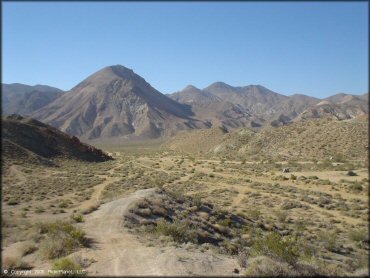
This is a good example of what you will find here. Rugged desert mountains and wide sandy trails with a little hard pack.
Jawbone Canyon Trail Photo
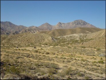
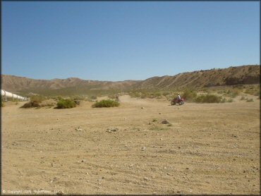
A view of one of the staging areas from a nearby hill. There are numerous spots like this as you head west on Jawbone Canyon Road.
Jawbone Canyon Trail Photo
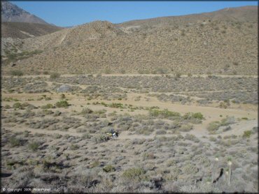
Some of the valley trails are wide and beginner friendly.
Jawbone Canyon Trail Photo
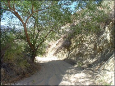
Most of the trails are sandy but some wind through interesting desert vegetation.
Jawbone Canyon Trail Photo
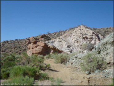
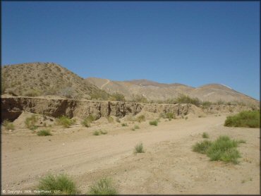
Some of the trails wind through and up some cool rock formations.
Jawbone Canyon Trail Photo
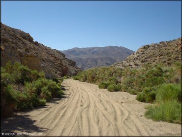
Most of the valley floor trails look like this and go on for miles. CamelBak and IMS fuel tank are a must.
Jawbone Canyon Trail Photo
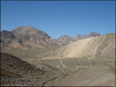
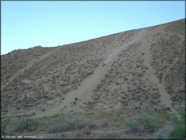
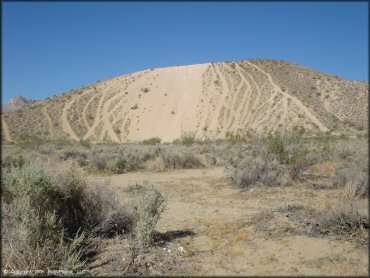
The photos just don't give these hill climbs justice. Only a big four-stroke or 500cc two-stroke (and a little skill) can get you to the top.
Jawbone Canyon Trail Photo
Another good view of the steep hill climbs. Some lines are smoother than others but either way, only the big toys can really make it to the top.
Jawbone Canyon Trail Photo
Jawbone Canyon Trail Photo
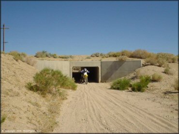
One of the sandy washes will take you through a drainage tunnel, which is a lot of fun.
Jawbone Canyon Trail Photo
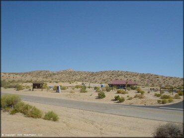
The Jawbone Canyon Visitor Center is stocked with maps, guide books and knowledgeable staff.
Jawbone Canyon Trail Photo
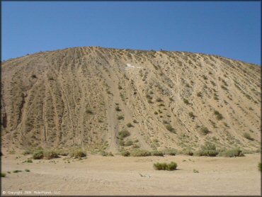
Only big four-stokes or 500cc two-strokes should attempt these huge hillclimbs!
Jawbone Canyon Trail Photo
As you can see, only the big four-stokes or 500cc two-strokes should even attempt these massive hillclimbs!
Jawbone Canyon Trail Photo
Jawbone Canyon Trail Photo
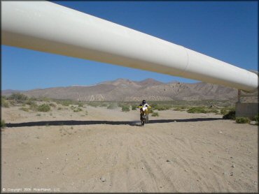
Having a little fun underneath in the desert.
Jawbone Canyon Trail Photo
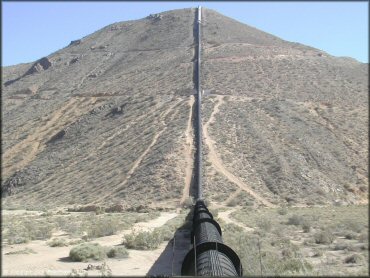
A view of the Los Angeles Aqueduct pipeline. Built in 1913, this pipeline stretches over 233 miles long and supplies the city with almost half of its drinking water.
RIDER COMMENTS & REVIEWS