 |
      |
| Home > California > Baldy Mesa |
Baldy Mesa
Wednesday, September 3, 2025
| Other Names | San Bernardino National Forest, Front Country Ranger District, Trestles, Cajon Pass |
| Last Known Status | Open |
This popular area recently reopened after a period of closure due to fire damage. Thanks to the Forest Service, California State Parks and local clubs, improvements have been made which include the addition of a designated staging area with picnic tables, signage, loading ramp and restrooms.
The ATV trails are marked and rated and have moderate elevation changes and many follow a ridgeline. Vegetation is sparse but consists of various scrub brush and Joshua trees.
An "Adventure Pass" is required for all vehicles parked in the staging areas, which can be picked up at the local ranger station. Call before you haul.
REGULATIONS
| Permit Required | Yes | CA OHMVR stickers required |
| Dates Open | Year-Round | CA OHMVR red sticker vehicles permitted from Oct 1 to April 30 |
| Other ATV Stickers Accepted | Yes | Residents of any state not listed must purchase a Nonresident OHV Use Permit. (AR, AZ, CA, CO, CT, DE, IA, ID, IN, LA, MA, MD, ME, MI, MN, MO, MT, ND, NH, NJ, NM, NV, NY, OH, OK, OR, PA, RI, TX, UT, VT, WA, WI, WY) |
| Spark Arrestor | Yes | A spark arresting exhaust silencer or end cap is required for all vehicles. |
| Noise Limit | Yes (96 dB) | CA OHMVR noise limits apply (1985/older limit 101 dB, 1986/newer limit 96 dB) |
| Whip Flags | Not Required | |
| Maximum Vehicle Width | Yes (50 inches) | has entrance gate or posts |
 Motorcycles & Dirt Bikes Motorcycles & Dirt Bikes | Permitted | CA OHMVR stickers required |
 ATVs ATVs | Permitted | CA OHMVR stickers required (maximum width 50 inches) |
 UTV & SXS UTV & SXS | Permitted | CA OHMVR stickers required (maximum width 50 inches) |
 SUVs & Jeeps (registered) SUVs & Jeeps (registered) | Some Areas | permitted on designated forest service roads |
| Dune Buggy & Sand Rail 4x4 (unregistered) | Some Areas | CA OHMVR stickers required (maximum width 50 inches) permitted on designated forest service roads |
| 2 Stroke Engines | Certain Times | CA OHMVR restrictions apply |
| MX Helmet Required | Yes | helmets required by state law |
 Camping Camping | Prohibited | |
 Campfires Campfires | Prohibited | |
| Night Riding | No | riding permitted during daylight hours only |
| Trail Blazing | Prohibited | stay on designated trails |
| Rule Enforcement |
TERRAIN
| Approx Size | 6,400 acres (10 sq mi) | |
| Miles Of Trail | 23 | |
| Climate Type | Desert | |
| Elevation | 3450 to 4600 ft. | |
| Trail Maintenance | Marked, Rated, Lightly Maintained | |
| Loose Dirt |  Little Little | |
| Hard Pack |  Mostly Mostly | |
| Sand |  Some Some | |
| Mud | Little | |
| Dust | Some | |
| Rocks | Some | |
| Trees |  Few Few | |
| Steep Hills | Few | |
| Water Crossings |  None None | |
| Small Jumps | Some | |
| Large Jumps | None | |
| Berms | Some | |
| Sand/Gravel Pits | None | |
| Single Track | None | |
| Roads | Some | |
| Shade | None | |
| Hazards | Few | (hazards assumed marked but use caution) |
 Novice Novice | Little | |
 Amateur Amateur | Mostly | |
 Expert Expert | Little |
TYPE OF AREA
| Area | Motorized Trails |
| Land | National Forest |


KEY SERVICES
 Gasoline Gasoline | 1-5 Miles (SW) | Circle K (760) 249-6105 |
| Diesel | 1-5 Miles (SW) | Circle K (760) 249-6105 |
 Water Water | 5-20 Miles (SW) | Bonita Ranch Campground and RV Sites (909) 887-3643 |
 RV Hookup RV Hookup | 5-20 Miles (SW) | Bonita Ranch Campground and RV Sites (909) 887-3643 |
 RV Disposal RV Disposal | 5-20 Miles (SW) | Bonita Ranch Campground and RV Sites (909) 887-3643 |
| Campground | 5-20 Miles (SW) | Applewhite Campground (909) 382-2851 |
 Conv Store Conv Store | 1-5 Miles (SW) | Circle K (760) 249-6105 |
FEES & PASSES
| Parking | Yes ($5.00) Adventure Pass Fee - $5/day or $30/year |
| Entry | (None) |
| Riding | (None) |
| Camping | (None) |
RATINGS
| Our Rating |  Good Good |
| Recommended Stay | Full Day |
| Comments | (Scroll Down For Rider Reviews & Comments) |
DRIVING DIRECTIONS
| Nearest City | Phelan, CA | ||
| Address | Santa Fe Road, Phelan, CA 92371 | ||
| From: San Bernardino, CA
1) Take I-15 North to Exit 131 2) As you exit the off ramp look to right for dirt road that runs parallel to I-215 North, turn here (do not get back on freeway) 3) Follow dirt road north about 1.5 miles toward staging area. |


OFFICIAL CONTACTS
| Contact Info | San Bernardino National Forest - Front Country Ranger District 1209 Lytle Creek Road Lytle Creek, CA 92358 (909) 382-2851 mailroom_r5_san_bernardino@fs.fed.us www.fs.usda.gov |
Baldy Mesa Trail Photo
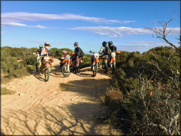
Photo Submitted 10/14/2019 (Thanks!)
Baldy Mesa Trail Photo
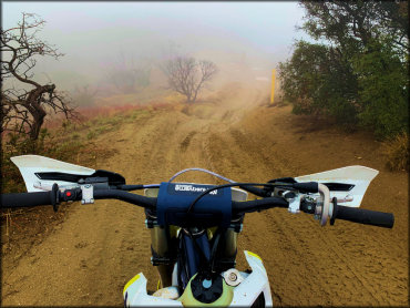
Photo Submitted 1/24/2020 (Thanks!)
Baldy Mesa Trail Photo
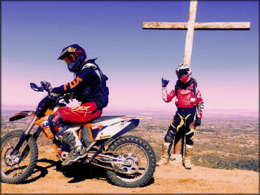
Photo Submitted 10/14/2019 (Thanks!)
Baldy Mesa Trail Photo
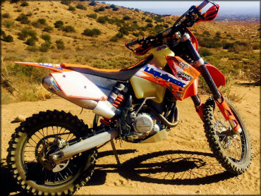
Photo Submitted 10/14/2019 (Thanks!)
RIDER COMMENTS & REVIEWS