 |
      |
| Home > California > Ortega Trail |
Ortega Trail
Thursday, April 30, 2026
| Other Names | Ojai Ranger District, Sespe Creek, Los Padres National Forest, Wheeler Gorge Campground, Holiday Group Campground, Ortega Vieja, Cherry Creek Road |
| Last Known Status | Open |
This rugged motorcycle trail winds through thick vegetation and offers panoramic mountain and canyon views but should only be attempted by the advanced rider due to loose chunk rock, narrow switchbacks, steep climbs and descents.
There are two access points but the northern entrance (Cherry Creek Road) is gated and is seasonally open between August 1 through December 15. Visitors should note that Cherry Creek Road is rough and should only be attempted with a high clearance vehicle (RVs not recommended).
The southern trailhead has a very small parking area (enough for one compact vehicle) but is only open from May through November 1.
Camping is available at Wheeler Gorge and Holiday Group campgrounds. Both campgrounds do not have direct trail access but are recommended for those with street legal motorcycles (the southern trailhead is located about one mile north past the campgrounds). A primitive campsite can be found about five miles in on the trail.
This trail may temporarily close during inclement weather so check with the Ojai Ranger District before heading out. Be sure to say thanks to the Ojai Valley Dirt Riders for maintaining this trail.
REGULATIONS
| Permit Required | Yes | CA OHMVR stickers required |
| Dates Open | May 1 - November 1 | CA OHMVR red sticker vehicles permitted from 10/1 to 4/30 |
| Other ATV Stickers Accepted | Yes | Residents of any state not listed must purchase a Nonresident OHV Use Permit. (AR, AZ, CA, CO, CT, DE, IA, ID, IN, LA, MA, MD, ME, MI, MN, MO, MT, ND, NH, NJ, NM, NV, NY, OH, OK, OR, PA, RI, TX, UT, VT, WA, WI, WY) |
| Spark Arrestor | Yes | A spark arresting exhaust silencer or end cap is required for all vehicles. |
| Noise Limit | Yes (96 dB) | CA OHMVR noise limits apply (1985/older limit 101 dB, 1986/newer limit 96 dB) |
| Whip Flags | Not Required | |
| Maximum Vehicle Width | ||
 Motorcycles & Dirt Bikes Motorcycles & Dirt Bikes | Permitted | CA OHMVR stickers required |
 ATVs ATVs | Prohibited | CA OHMVR stickers required |
 UTV & SXS UTV & SXS | Prohibited | CA OHMVR stickers required |
 SUVs & Jeeps (registered) SUVs & Jeeps (registered) | Prohibited | |
| Dune Buggy & Sand Rail 4x4 (unregistered) | Prohibited | CA OHMVR stickers required |
| 2 Stroke Engines | Certain Times | CA OHMVR restrictions apply |
| MX Helmet Required | Yes | helmets required by state law |
 Camping Camping | ||
 Campfires Campfires | ||
| Night Riding | Unknown | Not Recommended |
| Trail Blazing | Prohibited | vehicles must stay on trail |
| Rule Enforcement |
TERRAIN
| Approx Size | 5,120 acres (8 sq mi) | |
| Miles Of Trail | 9 | |
| Climate Type | Forest | |
| Elevation | 3700 to 5200 ft. | |
| Trail Maintenance | Marked, Rated, Heavily Maintained | |
| Loose Dirt |  Little Little | |
| Hard Pack |  Mostly Mostly | |
| Sand |  None None | |
| Mud | Little | |
| Dust | Little | |
| Rocks | Mostly | |
| Trees |  Many Many | |
| Steep Hills | Many | |
| Water Crossings | None | |
| Small Jumps | None | |
| Large Jumps | None | |
| Berms | None | |
| Sand/Gravel Pits | None | |
| Single Track |  All All | |
| Roads | None | |
| Intersections | None | |
| Rider Traffic |  Few Few | |
| Shade |  Some Some | |
| Hazards | Few | (hazards assumed marked but use caution) |
 Novice Novice | None | |
 Amateur Amateur | Little | |
 Expert Expert | Mostly |
TYPE OF AREA
| Area | Motorized Trails |
| Land | National Forest |


KEY SERVICES
 Gasoline Gasoline | 5-20 Miles (S) | American Gas and Mini Mart (805) 646-1021 |
| Diesel | 5-20 Miles (S) | American Gas and Mini Mart (805) 646-1021 |
 Water Water | 1-5 Miles (S) | Holiday Group Campground (805) 640-1977 |
 RV Hookup RV Hookup | 5-20 Miles (S) | Lake Casitas Recreation Area (805) 649-2233 or (805) 649-1122 |
 RV Disposal RV Disposal | 5-20 Miles (S) | Lake Casitas Recreation Area (805) 649-2233 or (805) 649-1122 |
| Campground | 1-5 Miles (S) | Wheeler Gorge Campground (805) 640-1977 |
 Conv Store Conv Store | 5-20 Miles (S) | American Gas and Mini Mart (805) 646-1021 |
FEES & PASSES
| Parking | Yes ($5.00) Adventure Pass Fee - $5/day or $30/year |
| Entry | (None) |
| Riding | (None) |
| Camping | Yes Tent: $35.00 RV: $35.00 Addtl. Vehicle: $10.00 Wheeler Gorge Campground Fee |
| Comment | Wheeler Gorge Campground requires reservations at least three days in advance - call (877) 444-6777. Adventure Pass can be purchased at campground. |
RATINGS
| Our Rating |  Good Good |
| Recommended Stay | Full Day |
| Comments | (Scroll Down For Rider Reviews & Comments) |
DRIVING DIRECTIONS
| Nearest City | Ojai, CA | ||
| Address | Cherry Creek Road, Ojai, CA 93023 | ||
| From: Ventura, CA
For the southern entrance: 1) Take SR-33 North about 40 miles 2) Trailhead is on the left (west). For the northern entrance (trailers not recommended): 3) Continue north about 17.5 miles 4) Turn left (south) onto Cherry Creek Road, continue about 3 miles. |


OFFICIAL CONTACTS
| Contact Info | Los Padres National Forest - Ojai Ranger District 1190 E. Ojai Ave. Ojai, CA 93023 (661) 245-3731 (661) 805-1057 mailroom_r5_los_padres@fs.fed.us www.fs.usda.gov |
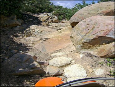
Ortega Trail Photo
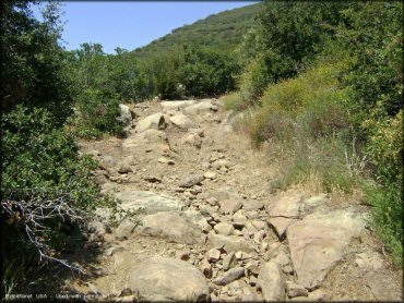
The trail has a lot of chunky sections. This is a good place to test your rock crawling skills.
Ortega Trail Photo
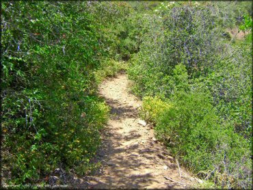
Photo Submitted 6/14/2009 (Thanks!)
Ortega Trail Photo
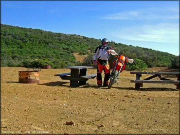
Ortega Vieja campsite can be found about five miles in if coming from the south. The campsite is remote but has a couple picnic tables and fire rings.
Ortega Trail Photo
Most of the trail looks like this - rocky and narrow.
Ortega Trail Photo
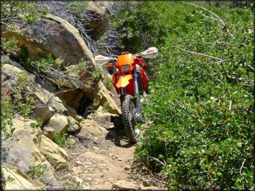
Photo Submitted 6/14/2009 (Thanks!)
Ortega Trail Photo
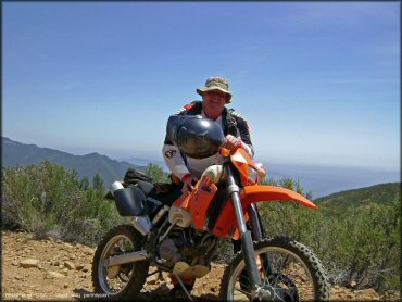
Photo Submitted 6/14/2009 (Thanks!)
Ortega Trail Photo
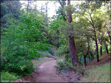
Some sections do smooth out for a short distance.
Ortega Trail Photo
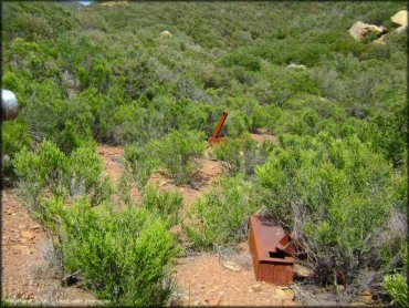
Photo Submitted 6/14/2009 (Thanks!)
Ortega Trail Photo
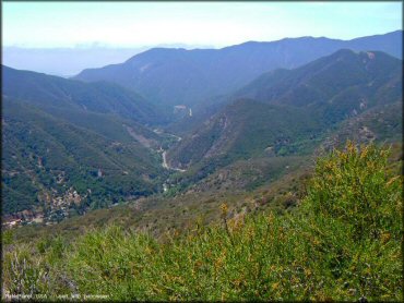
A view of Highway 33.
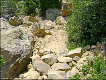
Ortega Trail Photo
A view of a chunky climb.
RIDER COMMENTS & REVIEWS