 |
      |
| Home > California > Niagara |
Niagara OHV Area
Sunday, May 31, 2026
| Other Names | Stanislaus National Forest, Summit Ranger District, Herring Creek Area, Niagara Ridge OHV Area, Niagara Creek, Eagle Meadow Road, No Way Out Hill, Lions Butt, Hard Brake Hill, Niagara Creek Campground, Double Dome Rock, Donnell Lake, Barn Meadow, Martins Cow Camp, Eagle Creek, Long Valley Creek, Rock Pile |
| Last Known Status | Open |
This part of the Stanislaus National Forest this area offers about five miles of rugged 4x4 trails. The trails are mostly wide and hard packed but many have obstacles that range from chunky loose rock to massive rock boulders with steep granite slabs.
Camping can be found at Niagara Campground which has ten primitive sites, each with a picnic table and fire ring. A vault toilet is available but drinking water is not so bring your own supplies. Sites are first come, first serve. The campground is usually accessible around late May though September, but exact dates vary. Call first for current conditions.
REGULATIONS
| Permit Required | Yes | CA OHMVR stickers required |
| Dates Open | May - September | CA OHMVR red sticker vehicles permitted year round |
| Other ATV Stickers Accepted | Yes | Residents of any state not listed must purchase a Nonresident OHV Use Permit. (AR, AZ, CA, CO, CT, DE, IA, ID, IN, LA, MA, MD, ME, MI, MN, MO, MT, ND, NH, NJ, NM, NV, NY, OH, OK, OR, PA, RI, TX, UT, VT, WA, WI, WY) |
| Spark Arrestor | Yes | A spark arresting exhaust silencer or end cap is required for all vehicles. |
| Noise Limit | Yes (96 dB) | CA OHMVR noise limits apply (1985/older limit 101 dB, 1986/newer limit 96 dB) |
| Whip Flags | Not Required | |
| Maximum Vehicle Width | No Restriction | |
 Motorcycles & Dirt Bikes Motorcycles & Dirt Bikes | Permitted | CA OHMVR stickers required |
 ATVs ATVs | Permitted | CA OHMVR stickers required |
 UTV & SXS UTV & SXS | Permitted | CA OHMVR stickers required |
 SUVs & Jeeps (registered) SUVs & Jeeps (registered) | Permitted | |
| Dune Buggy & Sand Rail 4x4 (unregistered) | Permitted | CA OHMVR stickers required |
| 2 Stroke Engines | No Restriction | CA OHMVR restrictions apply |
| MX Helmet Required | Yes | helmets required by state law |
 Camping Camping | No Restriction | (camp anywhere) |
 Campfires Campfires | ||
| Night Riding | Unknown | |
| Trail Blazing | Prohibited | vehicles must stay on trail |
| Rule Enforcement |
TYPE OF AREA
| Area | Motorized Trails |
| Land | National Forest |
FEES & PASSES
| Parking | (None) |
| Entry | (None) |
| Riding | (None) |
| Camping | Yes Tent: $20.00 RV: $20.00 Addtl. Vehicle: $0.00 Niagara OHV Campground Fee |
RATINGS
| Our Rating |  Good Good |
| Recommended Stay | 1-2 Days |
| Comments | (Scroll Down For Rider Reviews & Comments) |
DRIVING DIRECTIONS
| Nearest City | Pinecrest, CA | ||
| Address | Eagle Meadow Road, Pinecrest, CA 95364 | ||
| From: Pinecrest, CA
1) Take SR-108 North 14 miles 2) Turn right (east) on Eagle Meadow Road, continue 2.7 miles 3) Campground entrance is on the left (north). |


OFFICIAL CONTACTS
| Contact Info | Stanislaus National Forest - Summit Ranger District #1 Pinecrest Lake Road Pinecrest, CA 95364 (209) 965-3434 sm.fs.stanislausnf@usda.gov www.fs.usda.gov |
Niagara Trail Photo
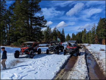
Photo Submitted 4/16/2022 (Thanks!)
ADD PHOTOS
TERRAIN
| Approx Size | 1,000 acres (2 sq mi) | |
| Miles Of Trail | 20 | |
| Climate Type | Forest | |
| Elevation | 6000 to 8000 ft. | |
| Trail Maintenance | Marked, Not Rated, Lightly Maintained | |
| Loose Dirt |  Little Little | |
| Hard Pack |  Mostly Mostly | |
| Sand |  None None | |
| Mud | Little | |
| Dust | Little | |
| Rocks | Mostly | |
| Trees |  All All | |
| Steep Hills |  Some Some | |
| Small Jumps | None | |
| Large Jumps | None | |
| Berms | None | |
| Single Track | None | |
| Roads | Some | |
| Shade |  Many Many | |
| Hazards |  Few Few | (hazards assumed marked but use caution) |
 Novice Novice | Some | |
 Amateur Amateur | Mostly | |
 Expert Expert | Little |
GPS POINTS


KEY SERVICES
 Gasoline Gasoline | 20-30 Miles (SW) | Chevron (209) 586-3552 |
| Diesel | 20-30 Miles (SW) | Chevron (209) 586-3552 |
 Water Water | Pinecrest, CA | |
 RV Hookup RV Hookup | 20-30 Miles (SW) | Sugar Pine RV Park (209) 586-4631 |
 RV Disposal RV Disposal | 20-30 Miles (SW) | Sugar Pine RV Park (209) 586-4631 |
| Campground | On Site | |
 Conv Store Conv Store | 20-30 Miles (SW) | Sonny's Mini Mart (209) 586-4662 |
RIDER COMMENTS & REVIEWS