 |
      |
| Home > California > Littlerock |
Littlerock OHV Area
Wednesday, July 30, 2025
| Other Names | Angeles National Forest, Little Rock OHV Area, Santa Clara / Mojave Rivers Ranger District, Rocky Point, Alimony Ridge OHV Route, Little Rock Creek, Little Rock Reservoir, Littlerock Dam, Mt. Emma, Santiago Canyon |
| Last Known Status | Temporarily Closed (due to dredging operations) |
This popular offroad area offers about 6 miles of trails that begin near the Santiago Canyon picnic area and heads east past the Little Rock Dam. The trails are narrow and rugged but provides nice views of the surrounding mountains and reservoir.
A large pit area is also available and is popular with the 4x4 crowd which can get very muddy during wet weather conditions. The dam also has several picnic areas that have shade gazebos and restroom facilities.
An Adventure Pass is required for all vehicles entering which must be purchased prior to entry since there is no self pay kiosk (the nearest vendor that sells the pass is Walmart). This area is only open for riding during daylight hours.
REGULATIONS
| Permit Required | Yes | CA OHMVR stickers required |
| Dates Open | Saturday and Sunday 9am-5pm | CA OHMVR red sticker vehicles permitted from 10/1 to 4/30 |
| Other ATV Stickers Accepted | Yes | Residents of any state not listed must purchase a Nonresident OHV Use Permit. (AR, AZ, CA, CO, CT, DE, IA, ID, IN, LA, MA, MD, ME, MI, MN, MO, MT, ND, NH, NJ, NM, NV, NY, OH, OK, OR, PA, RI, TX, UT, VT, WA, WI, WY) |
| Spark Arrestor | Yes | A spark arresting exhaust silencer or end cap is required for all vehicles. |
| Noise Limit | Yes (96 dB) | CA OHMVR noise limits apply (1985/older limit 101 dB, 1986/newer limit 96 dB) |
| Whip Flags | Not Required | |
| Maximum Vehicle Width | Yes (50 inches) | has entrance gate or posts |
 Motorcycles & Dirt Bikes Motorcycles & Dirt Bikes | Permitted | CA OHMVR stickers required |
 ATVs ATVs | Permitted | CA OHMVR stickers required (maximum width 50 inches) |
 UTV & SXS UTV & SXS | Permitted | CA OHMVR stickers required (maximum width 50 inches) |
 SUVs & Jeeps (registered) SUVs & Jeeps (registered) | Some Areas | permitted in pit area |
| Dune Buggy & Sand Rail 4x4 (unregistered) | Some Areas | CA OHMVR stickers required (maximum width 50 inches) permitted in pit area |
| 2 Stroke Engines | Certain Times | CA OHMVR restrictions apply |
| MX Helmet Required | Yes | helmets required by state law |
 Camping Camping | Prohibited | |
 Campfires Campfires | Prohibited | |
| Night Riding | No | trails open sunrise to sunset |
| Trail Blazing | Prohibited | stay on designated trails |
| Rule Enforcement |
TYPE OF AREA
| Area | Motorized Trails |
| Land | National Forest |
FEES & PASSES
| Parking | Yes ($5.00) Adventure Pass Fee - $5/day or $30/year |
| Entry | (None) |
| Riding | (None) |
| Camping | (None) |
RATINGS
| Our Rating |  Good Good |
| Recommended Stay | Full Day |
| Comments | (Scroll Down For Rider Reviews & Comments) |
DRIVING DIRECTIONS
| Nearest City | Littlerock, CA | ||
| Address | Cheseboro Road, Littlerock, CA 93543 | ||
| From: Palmdale, CA
1) Take SR-14 South to Exit 30 2) Turn left (north) at intersection onto Sierra Hwy, continue 5.5 miles 3) Turn right (south) on 57th Street, continue about 5 miles to staging area. |


OFFICIAL CONTACTS
| Contact Info | Angeles NF - Santa Clara And Mojave Rivers Ranger District 33708 Crown Valley Road Acton, CA 93510 (661) 269-2808 sm.fs.angeles_info@usda.gov www.fs.usda.gov |
| Contact Info | Walmart 37140 47Th Street East Palmdale, CA 93552 (661) 533-0248 |
| Comment | Sells Adventure Passes |
Littlerock Trail Photo
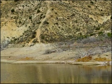
Photo Submitted 3/8/2015 (Thanks!)
ADD PHOTOS
TERRAIN
| Approx Size | 4,480 acres (7 sq mi) | |
| Miles Of Trail | 6 | |
| Climate Type | Forest | |
| Elevation | 3400 to 4700 ft. | |
| Trail Maintenance | Marked, Not Rated, Lightly Maintained | |
| Loose Dirt |  Little Little | |
| Hard Pack |  Mostly Mostly | trails are mostly hardpacked |
| Sand | Little | |
| Mud | Mostly | pit area can get very muddy during wet weather |
| Dust |  Some Some | |
| Rocks | Some | |
| Trees |  Few Few | |
| Steep Hills | Some | |
| Water Crossings | Some | |
| Small Jumps | Few | |
| Large Jumps |  None None | |
| Berms | Few | |
| Hazards | Few | (hazards assumed marked but use caution) |
 Novice Novice | Some | |
 Amateur Amateur | Mostly | |
 Expert Expert | Little |
GPS POINTS


KEY SERVICES
 Gasoline Gasoline | 5-20 Miles (NE) | Littlerock Mini'n Gas (661) 944-0654 |
| Diesel | 5-20 Miles (NE) | Mobil (661) 944-6161 |
 Water Water | 5-20 Miles (W) | Californian RV Resort (661) 269-0919 |
 RV Hookup RV Hookup | 5-20 Miles (W) | Californian RV Resort (661) 269-0919 |
 RV Disposal RV Disposal | 5-20 Miles (W) | Californian RV Resort (661) 269-0919 |
| Campground | 30+ Miles (S) | Horse Flats Campground (626) 574-5200 |
 Conv Store Conv Store | 1-5 Miles (N) | Littlerock Dam General Store (661) 533-1923 |
RIDER COMMENTS & REVIEWS