 |
      |
| Home > California > Mt. Pinos East |
Mt. Pinos East OHV Trails
Thursday, April 30, 2026
| Other Names | Los Padres National Forest, Mt. Pinos Ranger District, Frazier Mountain, Yellow Jacket Canyon Trail, Snowy Trail, Whata Trail, Piru Creek Motorized Trail, Gold Hill Campground |
| Last Known Status | Open |
This large area offers about 200 miles of technical trails with several campground providing direct access. Most of the area consists of single track motorcycle trails that are geared for the advanced rider but there are some forest service roads that are open to all vehicle types.
There are several campgrounds with direct trail access, but sites are primitive and water is not available, so come prepared. All campgrounds except for Chuchupate Campground require an Adventure Pass which can be purchased online or by visiting the Mt. Pinos Ranger Station.
This area is also home to the notorious Snowy Trail, a double black diamond goat trail with sharp switchbacks, steep and rugged climbs plus loose chunk rock.
The trails usually close for the season in November and reopens around May but exact dates vary. Call before you haul.
REGULATIONS
| Permit Required | Yes | CA OHMVR stickers required |
| Dates Open | May - November 14 | CA OHMVR red sticker vehicles permitted from 10/1 to 4/30 |
| Other ATV Stickers Accepted | Yes | Residents of any state not listed must purchase a Nonresident OHV Use Permit. (AR, AZ, CA, CO, CT, DE, IA, ID, IN, LA, MA, MD, ME, MI, MN, MO, MT, ND, NH, NJ, NM, NV, NY, OH, OK, OR, PA, RI, TX, UT, VT, WA, WI, WY) |
| Spark Arrestor | Yes | A spark arresting exhaust silencer or end cap is required for all vehicles. |
| Noise Limit | Yes (96 dB) | CA OHMVR noise limits apply (1985/older limit 101 dB, 1986/newer limit 96 dB) |
| Whip Flags | Not Required | |
| Maximum Vehicle Width | ||
 Motorcycles & Dirt Bikes Motorcycles & Dirt Bikes | Permitted | CA OHMVR stickers required |
 ATVs ATVs | Some Areas | Not Recommended CA OHMVR stickers required permitted on designated forest service roads |
 UTV & SXS UTV & SXS | Some Areas | Not Recommended CA OHMVR stickers required permitted on designated forest service roads |
 SUVs & Jeeps (registered) SUVs & Jeeps (registered) | Some Areas | Not Recommended permitted on designated forest service roads |
| Dune Buggy & Sand Rail 4x4 (unregistered) | Some Areas | CA OHMVR stickers required permitted on designated forest service roads |
| 2 Stroke Engines | Certain Times | CA OHMVR restrictions apply |
| MX Helmet Required | Yes | helmets required by state law |
 Camping Camping | Some Areas | (camp in developed sites only) |
 Campfires Campfires | Some Areas | (permitted in developed campsites only) |
| Night Riding | Unknown | Not Recommended |
| Trail Blazing | Prohibited | stay on trail |
| Rule Enforcement |
TERRAIN
| Approx Size | 10,000 acres (16 sq mi) | |
| Miles Of Trail | 200 | |
| Climate Type | Forest | |
| Elevation | 2000 to 7800 ft. | |
| Trail Maintenance | Marked, Rated, Lightly Maintained | |
| Loose Dirt |  Little Little | |
| Hard Pack |  Mostly Mostly | |
| Sand |  None None | |
| Mud | Little | |
| Dust | Little | |
| Rocks | Mostly | |
| Trees |  Many Many | |
| Steep Hills | Many | |
| Water Crossings |  Some Some | |
| Small Jumps |  Few Few | |
| Large Jumps | None | |
| Berms | Some | |
| Sand/Gravel Pits | None | |
| Single Track | Many | |
| Roads | Few | |
| Shade | Many | |
| Hazards | Few | (hazards assumed marked but use caution) |
 Novice Novice | Little | |
 Amateur Amateur | Mostly | |
 Expert Expert | Some |
TYPE OF AREA
| Area | Motorized Trails |
| Land | National Forest |
GPS POINTS

KEY SERVICES
 Gasoline Gasoline | 1-5 Miles (NE) | Midway Market (661) 245-1790 |
| Diesel | 1-5 Miles (NE) | Midway Market (661) 245-1790 |
 Water Water | 20-30 Miles (SE) | Pyramid Lake RV Resort (661) 248-0100 |
 RV Hookup RV Hookup | 20-30 Miles (SE) | Pyramid Lake RV Resort (661) 248-0100 |
 RV Disposal RV Disposal | 20-30 Miles (SE) | Pyramid Lake RV Resort (661) 248-0100 |
| Campground | On Site | |
 Conv Store Conv Store | 1-5 Miles (NE) | Midway Market (661) 245-1790 |
FEES & PASSES
| Parking | Yes ($5.00) Adventure Pass Fee - $5/day or $30/year |
| Entry | (None) |
| Riding | (None) |
| Camping | Yes Tent: $30.00 RV: $30.00 Addtl. Vehicle: $10.00 Chuchupate Campground Fee |
| Comment | Chuchupate Campground no longer accepts an Adventure Pass. Kings, Goldhill, Dutchman and Halfmoon campgrounds require an Adventure Pass. |
RATINGS
| Our Rating |  Very Good Very Good |
| Recommended Stay | 1-2 Days |
| Comments | (Scroll Down For Rider Reviews & Comments) |
DRIVING DIRECTIONS
| Nearest City | Frazier Park, CA | ||
| Address | Frazier Mountain Road, Frazier Park, CA 93225 | ||
| From: Los Angeles, CA
1) Take I-5 North to Exit 205 2) Turn left (west) off the exit ramp onto Frazier Mountain Park Road, continue about 7 miles 3) Turn left (south) onto Lockwood Valley Road, continue .9 miles 4) Turn left (south-east) onto Frazier Mountain Road, continue .5 miles 5) Frazier Mountain Staging area is on the right. For Chuchupate Campground: 6) Continue past Frazier Mountain Staging Area 2 miles toward campground entrance. |


OFFICIAL CONTACTS
| Contact Info | Los Padres National Forest - Mt. Pinos Ranger District 34580 Lockwood Valley Road Frazier Park, CA 93225 (661) 245-3731 mailroom_r5_los_padres@fs.fed.us www.fs.usda.gov |
Mt. Pinos East Trail Photo
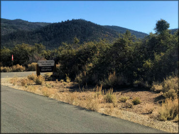
The Frazier Mountain Trailhead offers paved parking and plenty of room for trailers.
Mt. Pinos East Trail Photo
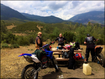
There is no shortage of scenery here!
Mt. Pinos East Trail Photo
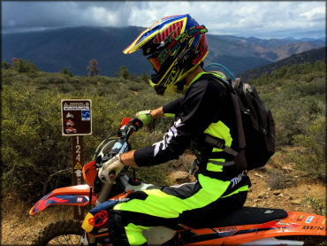
One of the many designated motorcycle trails.
Mt. Pinos East Trail Photo

Forest Service map of the Mt. Pinos trails and campgrounds.
RIDER COMMENTS & REVIEWS