 |
      |
| Home > California > San Jacinto |
San Jacinto OHV Trails
Monday, August 4, 2025
| Other Names | San Bernardino National Forest, Red Mountain OHV Road, Hixon, Allesandro Trail, Juan Diego Flat OHV Road, Bautista Canyon, Cahuilla Mountain |
| Last Known Status | Open |
This part of the San Bernardino National Forest offers two designated single track trails, an ATV trail and a 4x4 trail. The terrain can be described as mostly rugged hard pack with a few steep climbs and loose chunk rock.
There is currently no designated staging area but there is a small parking spot (enough for a compact truck) located across the Hixon Trailhead. This area is best explored on dual sport motorcycles but 4x4s can access the Red Mountain OHV Trail off of Tripp Flats Road.
REGULATIONS
| Permit Required | Yes | CA OHMVR stickers required |
| Dates Open | Year-Round | CA OHMVR red sticker vehicles permitted from 10/1 to 5/31 |
| Other ATV Stickers Accepted | Yes | Residents of any state not listed must purchase a Nonresident OHV Use Permit. (AR, AZ, CA, CO, CT, DE, IA, ID, IN, LA, MA, MD, ME, MI, MN, MO, MT, ND, NH, NJ, NM, NV, NY, OH, OK, OR, PA, RI, TX, UT, VT, WA, WI, WY) |
| Spark Arrestor | Yes | A spark arresting exhaust silencer or end cap is required for all vehicles. |
| Noise Limit | Yes (96 dB) | CA OHMVR noise limits apply (1985/older limit 101 dB, 1986/newer limit 96 dB) |
| Whip Flags | Not Required | |
| Maximum Vehicle Width | No Restriction | |
 Motorcycles & Dirt Bikes Motorcycles & Dirt Bikes | Permitted | CA OHMVR stickers required |
 ATVs ATVs | Some Areas | CA OHMVR stickers required permitted on Red Mountain and Hixon Trail |
 UTV & SXS UTV & SXS | Some Areas | CA OHMVR stickers required permitted on Red Mountain and Hixon Trail |
 SUVs & Jeeps (registered) SUVs & Jeeps (registered) | Some Areas | permitted on Red Mountain Trail |
| Dune Buggy & Sand Rail 4x4 (unregistered) | Some Areas | CA OHMVR stickers required permitted on Red Mountain Trail |
| 2 Stroke Engines | Certain Times | CA OHMVR restrictions apply |
| MX Helmet Required | Yes | helmets required by state law |
 Camping Camping | ||
 Campfires Campfires | ||
| Night Riding | Unknown | |
| Trail Blazing | Prohibited | stay on trail |
| Rule Enforcement |
Advertisement
TYPE OF AREA
| Area | Motorized Trails |
| Land | National Forest |
FEES & PASSES
| Parking | (None) |
| Entry | (None) |
| Riding | (None) |
| Camping | (None) |
RATINGS
| Our Rating |  Good Good |
| Recommended Stay | Full Day |
| Comments | (Scroll Down For Rider Reviews & Comments) |
DRIVING DIRECTIONS
| Nearest City | Hemet, CA | ||
| From: Hemet, CA
1) Take CA-74 East about 1 mile 2) Turn right (south) onto Fairview Ave, continue about 2 miles 3) Veer left (east) onto Bautista Canyon Road, continue about 5 miles 4) Hixon Trailhead is on the right (south-west). To access the Red Mountain OHV Trail: 5) Continue east past the Hixon Trailhead 9.5 miles 6) Turn right (south) on Tripp Flats Road, continue 1.9 miles 7) Turn right (west) onto Red Mountain Road, continue about 1 mile toward trailhead. |


OFFICIAL CONTACTS
| Contact Info | San Bernardino National Forest - Idyllwild Ranger Station 54270 Pine Crest Idyllwild, CA 92549 (909) 382-2921 mailroom_r5_san_bernardino@fs.fed.us www.fs.usda.gov |
San Jacinto Trail Photo
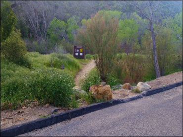
Photo Submitted 3/17/2017 (Thanks!)
ADD PHOTOS
TERRAIN
| Approx Size | 9,600 acres (15 sq mi) | |
| Miles Of Trail | 20 | |
| Climate Type | Forest | |
| Elevation | 2500 to 4500 ft. | |
| Trail Maintenance | Marked, Rated, Lightly Maintained | |
| Loose Dirt |  Little Little | |
| Hard Pack |  Mostly Mostly | |
| Sand |  Some Some | |
| Mud | Little | |
| Dust | Little | |
| Rocks | Some | |
| Trees |  Few Few | |
| Steep Hills |  Many Many | |
| Water Crossings |  None None | |
| Small Jumps | None | |
| Large Jumps | None | |
| Berms | Some | |
| Sand/Gravel Pits | None | |
| Single Track | Some | |
| Roads | Some | |
| Shade | Few | |
| Hazards | Few | (hazards assumed marked but use caution) |
 Novice Novice | Little | |
 Amateur Amateur | Mostly | |
 Expert Expert | Some |
GPS POINTS


KEY SERVICES
 Gasoline Gasoline | 5-20 Miles (NW) | Shell (909) 927-1046 |
| Diesel | 5-20 Miles (NW) | Shell (909) 927-1046 |
 Water Water | 5-20 Miles (SW) | Tecolote Springs RV Park (951) 767-0604 |
 RV Hookup RV Hookup | 5-20 Miles (SW) | Tecolote Springs RV Park (951) 767-0604 |
 RV Disposal RV Disposal | 5-20 Miles (SW) | Tecolote Springs RV Park (951) 767-0604 |
| Campground | 30+ Miles (NE) | Stone Creek Campground (800) 444-7275 |
 Conv Store Conv Store | 5-20 Miles (NW) | Shell (909) 927-1046 |
RIDER COMMENTS & REVIEWS