 |
      |
| Home > California > Miller Canyon |
Miller Canyon
Thursday, July 31, 2025
| Other Names | San Bernardino National Forest, Pilot Rock |
| Last Known Status | Open |
The San Bernardino National Forest opened this staging area to the public in September 2018, providing visitors direct access to long 4x4 loops that eventually head east and tie into Lake Arrowhead. The trails are mostly wide but hard packed forest roads with occasional loose chunk rock and some elevation changes, making this a good choice for jeeps or dual sport motorcycles.
Amenities include picnic tables, vault toilets, a beginners loop trail plus shady parking underneath mature oak and pine trees. An Adventure Pass is required which which must be obtained before arrival. Passes can be purchased at nearby ranger stations and stores. Camping is permitted as long as an Adventure Pass is displayed for each day/vehicle.
REGULATIONS
| Permit Required | Yes | CA OHMVR stickers required |
| Dates Open | Year-Round | CA OHMVR red sticker vehicles permitted from Oct 1 to April 30 |
| Other ATV Stickers Accepted | Yes | Residents of any state not listed must purchase a Nonresident OHV Use Permit. (AR, AZ, CA, CO, CT, DE, IA, ID, IN, LA, MA, MD, ME, MI, MN, MO, MT, ND, NH, NJ, NM, NV, NY, OH, OK, OR, PA, RI, TX, UT, VT, WA, WI, WY) |
| Spark Arrestor | Yes | A spark arresting exhaust silencer or end cap is required for all vehicles. |
| Noise Limit | Yes (96 dB) | CA OHMVR noise limits apply (1985/older limit 101 dB, 1986/newer limit 96 dB) |
| Whip Flags | Not Required | |
| Maximum Vehicle Width | No Restriction | |
 Motorcycles & Dirt Bikes Motorcycles & Dirt Bikes | Permitted | CA OHMVR stickers required |
 ATVs ATVs | Permitted | CA OHMVR stickers required |
 UTV & SXS UTV & SXS | Permitted | CA OHMVR stickers required |
 SUVs & Jeeps (registered) SUVs & Jeeps (registered) | Permitted | |
| Dune Buggy & Sand Rail 4x4 (unregistered) | Permitted | CA OHMVR stickers required |
| 2 Stroke Engines | Certain Times | CA OHMVR restrictions apply |
| MX Helmet Required | Yes | helmets required by state law |
 Camping Camping | Some Areas | (camp in developed sites only) |
 Campfires Campfires | Prohibited | campfires and charcoal bbq grills prohibited |
| Night Riding | Unknown | |
| Trail Blazing | Prohibited | riders must stay on trail |
| Rule Enforcement | ||
| Comment | Propane stoves and lanterns permitted with California Campfire Permit - call (909) 382-2851. | |
TYPE OF AREA
| Area | Motorized Trails |
| Land | National Forest |
FEES & PASSES
| Parking | (None) |
| Entry | Yes ($5.00 per vehicle) |
| Riding | (None) |
| Camping | (None) |
| Comment | Adventure Pass must be bought prior to entry; $5.00 for daily or $30 for Annual Pass. |
RATINGS
| Our Rating |  Good Good |
| Recommended Stay | Full Day |
| Comments | (Scroll Down For Rider Reviews & Comments) |
DRIVING DIRECTIONS
| Nearest City | Hesperia, CA | ||
| Address | Miller Road, Hesperia, CA 92345 | ||
| From: San Bernardino, CA
1) Take I-15 north to Exit 131 2) Turn right (east) onto Hwy 138, continue about 15 miles 3) Turn left (north) onto Miller Road, continue about .25 miles 4) Turn left (east) to stay on Miller Road, follow road toward staging area. |


OFFICIAL CONTACTS
| Contact Info | San Bernardino National Forest - Front Country Ranger District 1209 Lytle Creek Road Lytle Creek, CA 92358 (909) 382-2851 mailroom_r5_san_bernardino@fs.fed.us www.fs.usda.gov |
Miller Canyon Trail Photo
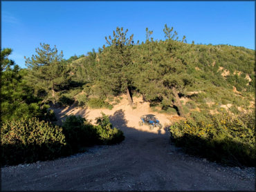
Photo Submitted 5/26/2020 (Thanks!)
Miller Canyon Trail Photo
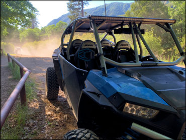
Photo Submitted 5/26/2020 (Thanks!)
ADD PHOTOS
TERRAIN
| Approx Size | 6,500 acres (10 sq mi) | |
| Miles Of Trail | 40 | |
| Climate Type | Forest | |
| Elevation | 3650 to 5200 ft. | |
| Trail Maintenance | Marked, Not Rated, Lightly Maintained | |
| Loose Dirt |  Little Little | |
| Hard Pack |  Mostly Mostly | |
| Sand |  None None | |
| Mud | Little | |
| Dust | Little | |
| Rocks |  Some Some | |
| Trees |  Many Many | |
| Steep Hills |  Few Few | |
| Water Crossings | None | |
| Small Jumps | Few | |
| Large Jumps | None | |
| Berms | Some | |
| Sand/Gravel Pits | None | |
| Single Track | Some | |
| Roads | Some | |
| Shade | Some | |
| Hazards | Few | (hazards assumed marked but use caution) |
 Novice Novice | Some | |
 Amateur Amateur | Mostly | |
 Expert Expert | Little |


KEY SERVICES
 Gasoline Gasoline | 5-20 Miles (S) | Shell (909) 338-0244 |
| Diesel | 5-20 Miles (S) | Chevron (909) 882-8313 |
 Water Water | 1-5 Miles (W) | Mesa Campground (760) 389-2303 |
 RV Hookup RV Hookup | 1-5 Miles (W) | Mesa Campground (760) 389-2303 |
 RV Disposal RV Disposal | 1-5 Miles (W) | Mesa Campground (760) 389-2303 |
| Campground | On Site | |
 Conv Store Conv Store | 5-20 Miles (S) | Shell (909) 338-0244 |
RIDER COMMENTS & REVIEWS