 |
      |
| Home > Colorado > Penrose Commons |
Penrose Commons
Saturday, May 10, 2025
| Other Names | Penrose ATV Trails, Royal Gorge Field Office, Box Canyon, Beaver Creek, Independence Trail System |
| Last Known Status | Open |
This large area has over 30 miles of ATV trails that range from fast and smooth to twisty and narrow with loose chunk rock. There are several scenic bluffs that provide outstanding views of the surrounding mountains and rolling hills. All trails are marked, rated and form numerous loops.
There is a separate set of trails located near the main staging area that is designed for Jeeps and modified trucks that features large boulders and narrow rock gardens with a variety of elevation changes. This trail system is geared for the experienced driver and modified vehicle.
The entrance road is wide and rough, but the main staging area has plenty of parking space with several spots that are big rig friendly. The main staging area has an information kiosk with trail maps and a vault toilet.
Camping is permitted but there are no services, so bring your own water and supplies. Vegetation ranges from various juniper trees, scrub brush and prickly pear cactus.
There is no fee charged to camp or ride but off road vehicles must display a current Colorado OHV Sticker. The trails are open year-round but may close temporarily during poor weather conditions. Be sure to call first before heading out since the main entrance road is gated and may close on short notice.
REGULATIONS
| Permit Required | Yes | Colorado OHV Sticker |
| Dates Open | Year-Round | |
| Other ATV Stickers Accepted | No | Colorado Non-Resident OHV permit required. |
| Spark Arrestor | Yes | A spark arresting exhaust silencer or end cap is required for all vehicles. |
| Noise Limit | Yes (96 dB) | (1998/older limit 99 dB, 1998/newer limit 96 dB) |
| Whip Flags | Not Required | |
| Maximum Vehicle Width | No Restriction | |
 Motorcycles & Dirt Bikes Motorcycles & Dirt Bikes | Permitted | |
 ATVs ATVs | Permitted | |
 UTV & SXS UTV & SXS | Permitted | |
 4x4 & Jeeps (registered) 4x4 & Jeeps (registered) | Permitted | |
| Dune Buggy & Sand Rail 4x4 (unregistered) | Permitted | |
| 2 Stroke Engines | No Restriction | |
| MX Helmet Required | Youth Only | Riders and passengers 17 and younger must wear a helmet. (RiderPlanet strongly recommends helmets for all riders.) |
 Camping Camping | No Restriction | (camp anywhere) |
 Campfires Campfires | ||
| Night Riding | Unknown | |
| Trail Blazing | Prohibited | stay on trail |
| Rule Enforcement |
TERRAIN
| Approx Size | 3,100 acres (5 sq mi) | |
| Miles Of Trail | 30 | |
| Climate Type | Desert | |
| Elevation | 5800 to 6200 ft. | |
| Trail Maintenance | Marked, Not Rated, Lightly Maintained | |
| Loose Dirt |  Little Little | |
| Hard Pack |  Mostly Mostly | |
| Sand |  None None | |
| Mud | Little | |
| Dust |  Some Some | |
| Rocks | Some | |
| Trees |  Few Few | |
| Steep Hills | Some | |
| Water Crossings | None | |
| Small Jumps | None | |
| Large Jumps | None | |
| Berms | Some | |
| Sand/Gravel Pits | None | |
| Single Track | Some | |
| Roads | None | |
| Shade | None | |
| Hazards | Few | (hazards assumed marked but use caution) |
 Novice Novice | Some | |
 Amateur Amateur | Mostly | |
 Expert Expert | Little |
TYPE OF AREA
| Area | Motorized Trails |
| Land | BLM |


KEY SERVICES
 Gasoline Gasoline | 1-5 Miles (S) | Kwik Stop (719) 276-8465 |
| Diesel | 1-5 Miles (S) | Kwik Stop (719) 276-8465 |
 Water Water | 5-20 Miles (W) | Indian Springs Ranch & Campground (719) 372-3907 |
 RV Hookup RV Hookup | 5-20 Miles (W) | Indian Springs Ranch & Campground (719) 372-3907 |
 RV Disposal RV Disposal | 5-20 Miles (W) | Indian Springs Ranch & Campground (719) 372-3907 |
| Campground | 5-20 Miles (W) | Indian Springs Ranch & Campground (719) 372-3907 |
 Conv Store Conv Store | 1-5 Miles (S) | Kwik Stop (719) 276-8465 |
FEES & PASSES
| Parking | (None) |
| Entry | (None) |
| Riding | (None) |
| Camping | (None) |
RATINGS
| Our Rating |  Good Good |
| Recommended Stay | Full Day |
| Comments | (Scroll Down For Rider Reviews & Comments) |
DRIVING DIRECTIONS
| Nearest City | Penrose, CO | ||
| From: Pueblo, CO
1) Take US-50 West to exit for SR-115 2) Turn right (north) off the exit ramp, continue 2.4 miles 3) Turn left (west) onto 3rd Street/CR-123, continue .3 miles 4) Turn right (north) onto E Street/CR-127, continue about 3 miles toward staging area. |


OFFICIAL CONTACTS
| Contact Info | BLM - Royal Gorge Field Office 3028 East Main Street Canon City, CO 81212 (719) 269-8500 blm_co_rg_visitorinfo@blm.gov www.blm.gov |
| Comment | Press extension 2 for trail info. |
| Contact Info | Colorado State Parks - Registration Unit 13787 South Highway 85 Littleton, CO 80125 (303) 791-1920 dnr.ivrsparks@state.co.us cpw.state.co.us |
Penrose Commons Trail Photo
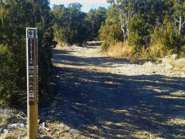
Photo Submitted 1/19/2016 (Thanks!)
Penrose Commons Trail Photo
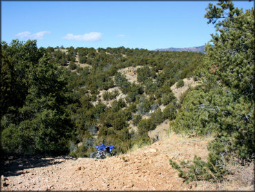
Photo Submitted 4/12/2016 (Thanks!)
Penrose Commons Trail Photo
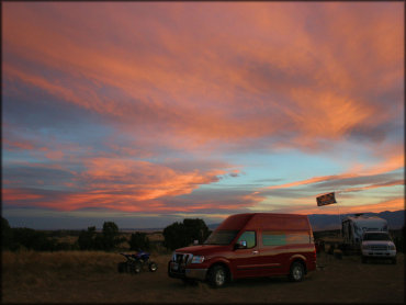
Photo Submitted 4/12/2016 (Thanks!)
Penrose Commons Trail Photo
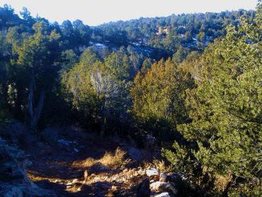
Photo Submitted 1/19/2016 (Thanks!)
RIDER COMMENTS & REVIEWS