 |
      |
| Home > Colorado > Texas Creek |
Texas Creek
Saturday, May 10, 2025
| Other Names | Texas Creek OHV Area, Arkansas River, Fernleaf Gulch, Maverick Gulch, Reese Gulch, Table Mountain, Bull Gulch, Long Gulch, Arkansas Headwaters Recreation Area, Big Horn Sheep Canyon, Tucker Trail |
| Last Known Status | Open |
This remote area has around 45 miles of marked trails that range from easy 4x4 roads to narrow and rocky ATV trails with sharp switchbacks. At lower elevations the trails wind through a mix of various scrub brush, juniper and pinon pine trees.
As you continue to climb in elevation, the vegetation changes to mostly spruce, aspen and Douglas-fir trees. Mule deer, bighorn sheep and elk can sometimes be seen in this area.
Nearby Texas Creek Adventures offers hiking, horseback riding, rock climbing, rafting and guided ATV tours. Camping is permitted but there are no services so come prepared.
REGULATIONS
| Permit Required | Yes | Colorado OHV sticker |
| Dates Open | Year-Round | |
| Other ATV Stickers Accepted | No | Colorado Non-Resident OHV permit required. |
| Spark Arrestor | Yes | A spark arresting exhaust silencer or end cap is required for all vehicles. |
| Noise Limit | Yes (96 dB) | (1998/older limit 99 dB, 1998/newer limit 96 dB) |
| Whip Flags | Not Required | |
| Maximum Vehicle Width | No Restriction | |
 Motorcycles & Dirt Bikes Motorcycles & Dirt Bikes | Permitted | |
 ATVs ATVs | Permitted | |
 UTV & SXS UTV & SXS | Permitted | |
 4x4 & Jeeps (registered) 4x4 & Jeeps (registered) | Permitted | |
| Dune Buggy & Sand Rail 4x4 (unregistered) | Permitted | |
| 2 Stroke Engines | No Restriction | |
| MX Helmet Required | Youth Only | Riders and passengers 17 and younger must wear a helmet. (RiderPlanet strongly recommends helmets for all riders.) |
 Camping Camping | No Restriction | (camp anywhere) |
 Campfires Campfires | ||
| Night Riding | Unknown | |
| Trail Blazing | Prohibited | stay on designated trails |
| Rule Enforcement |
TERRAIN
| Approx Size | 1,000 acres (2 sq mi) | |
| Miles Of Trail | 45 | |
| Climate Type | Desert | |
| Elevation | 6200 to 9000 ft. | |
| Trail Maintenance | Marked, Not Rated, Lightly Maintained | |
| Loose Dirt |  Little Little | |
| Hard Pack |  Mostly Mostly | |
| Sand |  Some Some | |
| Mud | Little | |
| Dust | Some | |
| Rocks | Mostly | |
| Trees | Some | |
| Steep Hills | Some | |
| Water Crossings |  None None | |
| Berms | Some | |
| Sand/Gravel Pits | None | |
| Single Track |  Few Few | |
| Roads | Some | |
| Shade | Some | |
| Hazards | Few | (hazards assumed marked but use caution) |
 Novice Novice | Some | |
 Amateur Amateur | Mostly | |
 Expert Expert | Little |
TYPE OF AREA
| Area | Motorized Trails |
| Land | BLM |


KEY SERVICES
 Gasoline Gasoline | Texas Creek, CO | |
| Diesel | Texas Creek, CO | |
 Water Water | 1-5 Miles (SW) | Sweetwater River Ranch (719) 276-3842 or (888) 793-3842 |
 RV Hookup RV Hookup | 1-5 Miles (SW) | Sweetwater River Ranch (719) 276-3842 or (888) 793-3842 |
 RV Disposal RV Disposal | 1-5 Miles (SW) | Sweetwater River Ranch (719) 276-3842 or (888) 793-3842 |
| Campground | Texas Creek, CO | |
 Conv Store Conv Store | 1-5 Miles (S) | Texas Creek Junction (719) 275-8828 |
FEES & PASSES
| Parking | (None) |
| Entry | (None) |
| Riding | (None) |
| Camping | (None) |
RATINGS
| Our Rating |  Good Good |
| Recommended Stay | Full Day |
| Comments | (Scroll Down For Rider Reviews & Comments) |
DRIVING DIRECTIONS
| Nearest City | Texas Creek, CO | ||
| From: Canon City, CO
1) Take SR-50 west about 25 miles 2) Turn right (north) onto Fremont County Road 27 (look for the Texas Creek Junction Mall and ATV Tours on the right) 3) Proceed over bridge and continue about .5 miles (follow signs for OHV parking). |


OFFICIAL CONTACTS
| Contact Info | BLM - Royal Gorge Field Office 3028 East Main Street Canon City, CO 81212 (719) 269-8500 www.blm.gov |
| Comment | Press extension 2 for trail info. |
| Contact Info | Colorado State Parks - Registration Unit 13787 South Highway 85 Littleton, CO 80125 (303) 791-1920 dnr.ivrsparks@state.co.us cpw.state.co.us |
Texas Creek Trail Photo
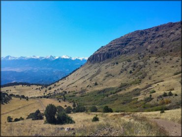
Photo Submitted 10/13/2014 (Thanks!)
Texas Creek Trail Photo
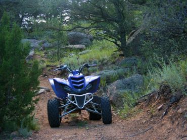
Photo Submitted 2/14/2016 (Thanks!)
Texas Creek Trail Photo
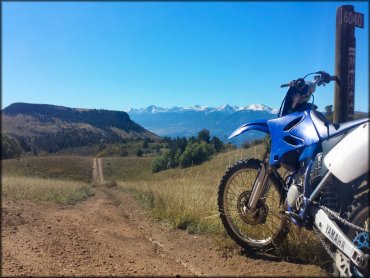
Photo Submitted 10/13/2014 (Thanks!)
Texas Creek Trail Photo
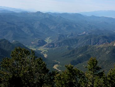
Photo Submitted 2/14/2016 (Thanks!)
Texas Creek Trail Photo
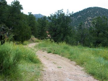
Photo Submitted 2/14/2016 (Thanks!)
Texas Creek Trail Photo
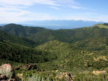
Photo Submitted 2/14/2016 (Thanks!)
RIDER COMMENTS & REVIEWS