 |
      |
| Home > Colorado > Red Cone |
Red Cone Trail System
Sunday, May 31, 2026
| Other Names | Red Cone Trail, Pike National Forest, North Fork South Platte River, Handcart Gulch, Handcart Gulch Creek, Webster Pass, Radical Hill, Snake River, South Platte Ranger District |
| Last Known Status | Open |
This challenging 4x4 trail is only open from late June through September (exact dates vary) but offers steep inclines and declines, rewarding scenic views and the occasional encounter with a mountain goat.
Only experienced off-road riders or drivers should attempt this trail due to some of the steep, narrow and rocky sections with heavy consequences for errors.
The main trail is about 10 miles long and it weaves through spruce and aspen pine at lower elevations, but as the elevation increases only tundra and more rocky sections will appear. Call before you haul.
REGULATIONS
| Permit Required | Yes | Colorado OHV Sticker |
| Dates Open | Late June - September | |
| Other ATV Stickers Accepted | No | Colorado Non-Resident OHV permit required. |
| Spark Arrestor | Yes | A spark arresting exhaust silencer or end cap is required for all vehicles. |
| Noise Limit | Yes (96 dB) | (1998/older limit 99 dB, 1998/newer limit 96 dB) |
| Whip Flags | Not Required | |
| Maximum Vehicle Width | No Restriction | |
 Motorcycles & Dirt Bikes Motorcycles & Dirt Bikes | Permitted | |
 ATVs ATVs | Permitted | |
 UTV & SXS UTV & SXS | Permitted | |
 4x4 & Jeeps (registered) 4x4 & Jeeps (registered) | Permitted | |
| Dune Buggy & Sand Rail 4x4 (unregistered) | Permitted | |
| 2 Stroke Engines | No Restriction | |
 Camping Camping | Some Areas | (camp in developed sites only) |
 Campfires Campfires | Some Areas | (permitted in developed campsites only) |
| Night Riding | Unknown | Not Recommended |
| Trail Blazing | Prohibited | vehicles must stay on trail |
| Alcohol | No Restriction | |
| Rule Enforcement | Few/Periodic |
TYPE OF AREA
| Area | Motorized Trails |
| Land | National Forest |
FEES & PASSES
| Parking | Yes ($11.00) day use fee if not camping |
| Entry | (None) |
| Riding | (None) |
| Camping | Yes Tent: $24.00 RV: $24.00 Addtl. Vehicle: $11.00 Handcart Gulch and Hall Valley Campground Fees |
RATINGS
| Pros | very scenic, challenging jeep trails |
| Cons | not recomended for novice riders/drivers, very steep and slippery, some sections are very narrow with 1,000 ft drops, trail available late June - Sept |
| Our Rating |  Good Good |
| Recommended Stay | 1-2 Days August-September |
| Comments | (Scroll Down For Rider Reviews & Comments) |
DRIVING DIRECTIONS
| Nearest City | Jefferson, CO | ||
| From: Fairplay, CO
1) Take Hwy 285 East about 25 miles 2) Turn left (north) on CR-60 3) Continue about 5 miles toward Handcart Gulch Campground 4) Stage at the campground. |


OFFICIAL CONTACTS
| Contact Info | Pike National Forest - South Platte Ranger District 19316 Goddard Ranch Court Morrison, CO 80465 (303) 275-5610 mailroom_r2_pike_san_isabel@fs.fed.us www.fs.usda.gov |
| Contact Info | Colorado State Parks - Registration Unit 13787 South Highway 85 Littleton, CO 80125 (303) 791-1920 dnr.ivrsparks@state.co.us cpw.state.co.us |
| Comment | Colorado OHV Registration Info |
| Contact Info | Mile High Adventure Rentals 1044 S Grapevine Road Golden, CO 80401 (303) 929-7239 milehighadventures@outlook.com |
| Comment | ATV, UTV, dirt bike and snowmobile rentals |
Red Cone Trail Photo
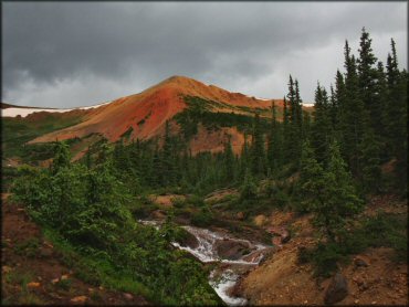
Photo Submitted 7/23/2013 (Thanks!)
Red Cone Trail Photo
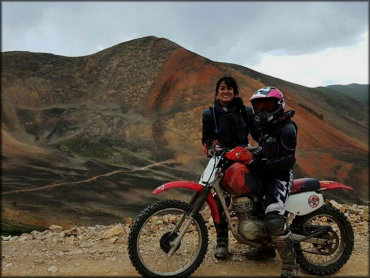
Photo Submitted 3/19/2017 (Thanks!)
Red Cone Trail Photo
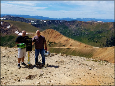
Photo Submitted 10/15/2020 (Thanks!)
ADD PHOTOS
TERRAIN
| Approx Size | 12,800 acres (20 sq mi) | |
| Miles Of Trail | 20 | |
| Climate Type | Forest | |
| Elevation | 9800 to 12800 ft. | |
| Trail Maintenance | Marked, Not Rated, Not Maintained | |
| Loose Dirt |  Some Some | |
| Hard Pack |  Little Little | |
| Sand |  None None | |
| Mud | Little | |
| Dust | Little | |
| Rocks |  Mostly Mostly | |
| Trees |  Many Many | |
| Steep Hills | Many | |
| Water Crossings |  Few Few | |
| Small Jumps | Few | |
| Sand/Gravel Pits | None | |
| Single Track | Few | |
| Roads | Few | |
| Intersections | Some | |
| Rider Traffic | Some | |
| Shade | Many | |
| Ranges/Gunfire | Few | |
| Hazards | Some | (hazards assumed marked but use caution) steep hills, rocky sections |
 Novice Novice | Little | |
 Amateur Amateur | Mostly | |
 Expert Expert | Some |
GPS POINTS


KEY SERVICES
 Gasoline Gasoline | 5-20 Miles (E) | Bailey |
| Diesel | 5-20 Miles (E) | Bailey |
 Water Water | 5-20 Miles (SW) | Jefferson |
 RV Hookup RV Hookup | 30+ Miles (NW) | Tiger Run RV Resort (970) 453-9690 |
 RV Disposal RV Disposal | 30+ Miles (NW) | Tiger Run RV Resort (970) 453-9690 |
| Campground | On Site | Handcart Gulch Campground |
 Conv Store Conv Store | 5-20 Miles (SW) | Jefferson Market (719) 836-2389 |
RIDER COMMENTS & REVIEWS