 |
      |
| Home > Colorado > Cuchara |
Cuchara Recreation Area
Thursday, May 14, 2026
| Other Names | Cuchara River Recreation Area, Indian Creek Trail, Trinchera Peak Trailhead, Bear Lake, Blue Lake, Cucheras Creek, Baker Creek, San Isabel National Forest, Dodgeton Creek, Raspberry Mountain, Harrison Peak, Napoleon Peak, Park Mountain, Steep Mountain, Boca Canyon, Hells Canyon, Bear Canyon, Cuatro Peak, Mt. Maxwell, Marquita Peak |
| Last Known Status | Open |
This popular summer destination offers scenic mountain views, beautiful aspen forest, camping, hiking, fishing and two designated OHV trails. Indian Creek trail is recommended for novice riders while Trinchera Peak trail proides more of a challenge for amateur riders. Portions of the trails may still be snow covered until early June. Mountain lions, wild turkey and black bear are among the many types of wildlife that inhabit this area.
REGULATIONS
| Permit Required | Yes | Colorado OHV Sticker |
| Dates Open | May 15 - November 15 | |
| Other ATV Stickers Accepted | No | Colorado Non-Resident OHV permit required. |
| Spark Arrestor | Yes | A spark arresting exhaust silencer or end cap is required for all vehicles. |
| Noise Limit | Yes (96 dB) | (1998/older limit 99 dB, 1998/newer limit 96 dB) |
| Whip Flags | Not Required | |
| Maximum Vehicle Width | No Restriction | |
 Motorcycles & Dirt Bikes Motorcycles & Dirt Bikes | Permitted | |
 ATVs ATVs | Permitted | |
 UTV & SXS UTV & SXS | Permitted | |
 4x4 & Jeeps (registered) 4x4 & Jeeps (registered) | Permitted | |
| Dune Buggy & Sand Rail 4x4 (unregistered) | Permitted | |
| 2 Stroke Engines | No Restriction | |
 Camping Camping | Some Areas | (camp in developed sites only) |
 Campfires Campfires | Some Areas | (permitted in developed campsites only) |
| Night Riding | Unknown | |
| Trail Blazing | Prohibited | stay on trail |
| Alcohol | No Restriction | |
| Rule Enforcement | Few/Periodic |
TERRAIN
| Approx Size | 25,600 acres (40 sq mi) | |
| Miles Of Trail | 25 | |
| Climate Type | Forest | |
| Elevation | 8500 to 12000 ft. | |
| Trail Maintenance | Marked, Not Rated, Not Maintained | |
| Loose Dirt |  Some Some | |
| Hard Pack | Some | |
| Sand |  None None | |
| Mud |  Little Little | |
| Dust | Little | |
| Rocks | Some | |
| Trees |  Many Many | |
| Steep Hills |  Few Few | |
| Small Jumps | Some | |
| Sand/Gravel Pits | None | |
| Roads | Few | |
| Intersections | Some | |
| Rider Traffic | Some | |
| Shade | Many | |
| Hazards | Few | (hazards assumed marked but use caution) |
 Novice Novice | Some | |
 Amateur Amateur |  Mostly Mostly | |
 Expert Expert | Little |
TYPE OF AREA
| Area | Motorized Trails |
| Land | National Forest, State Recreation |


KEY SERVICES
 Gasoline Gasoline | 5-20 Miles (NE) | Cliff Brice Corner Stop (719) 742-3442 |
| Diesel | 5-20 Miles (NE) | Cliff Brice Corner Shop (719) 742-3442 |
 Water Water | On Site | Bear Lake & Blue Lake campground |
 RV Hookup RV Hookup | 5-20 Miles (NE) | Mary's RV Park (719) 742-3252 |
 RV Disposal RV Disposal | 5-20 Miles (NE) | Mary's RV Park (719) 742-3252 |
| Campground | On Site | |
 Conv Store Conv Store | 5-20 Miles (NE) | Cuchara Country Store (719) 742-3450 |
FEES & PASSES
| Parking | (None) |
| Entry | (None) |
| Riding | (None) |
| Camping | Yes Tent: $13.00 RV: $13.00 Addtl. Vehicle: $13.00 |
RATINGS
| Our Rating |  Good Good |
| Recommended Stay | Full Day |
| Comments | (Scroll Down For Rider Reviews & Comments) |
DRIVING DIRECTIONS
| Nearest City | Cuchara, CO | ||
| From: Wolsenburg, CO
1) Take Hwy 160 West about 11 miles 2) Turn left (south) on Hwy 12, continue about 20 miles 3) Turn right on NF-422 4) Proceed 3.7 miles to the Blue Lake campgorund. Bear Lake campground is located about 1 mile past Blue Lake campground. |

OFFICIAL CONTACTS
| Contact Info | Pike And San Isabel National Forest 2840 Kachina Drive Pueblo, CO 81008 (719) 553-1400 mailroom_r2_pike_san_isabel@fs.fed.us www.fs.usda.gov |
| Contact Info | Colorado State Parks - Registration Unit 13787 South Highway 85 Littleton, CO 80125 (303) 791-1920 dnr.ivrsparks@state.co.us www.cpwshop.com |
| Comment | Colorado OHV Registration Info |
Cuchara Trail Photo
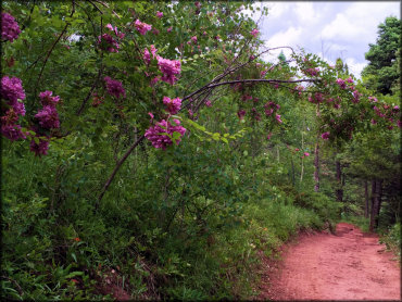
Photo Submitted 10/6/2015 (Thanks!)
Cuchara Trail Photo
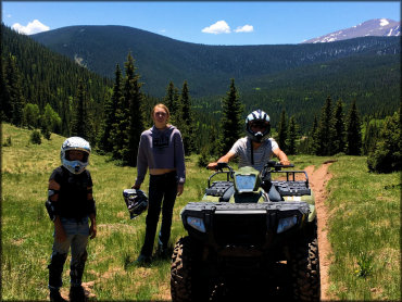
Photo Submitted 7/2/2019 (Thanks!)
Cuchara Trail Photo
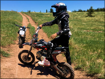
Photo Submitted 7/2/2019 (Thanks!)
Cuchara Trail Photo
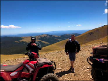
Photo Submitted 7/30/2020 (Thanks!)
RIDER COMMENTS & REVIEWS