 |
      |
| Home > Colorado > Seep Springs |
Seep Springs
Saturday, May 10, 2025
| Other Names | Four Mile Creek |
| Last Known Status | Open |
This high desert area has about 16 miles of ATV trails that wind through mixed juniper and pinion pine trees. The trails start out mostly smooth but get rockier and narrow as you climb in elevation. Camping is permitted but is primitive. The area is open year-round but the trails may close temporarily during wet weather. Call first before heading out.
REGULATIONS
| Permit Required | Yes | Colorado OHV Sticker |
| Dates Open | Year-Round | |
| Other ATV Stickers Accepted | No | Colorado Non-Resident OHV permit required. |
| Spark Arrestor | Yes | A spark arresting exhaust silencer or end cap is required for all vehicles. |
| Noise Limit | Yes (96 dB) | (1998/older limit 99 dB, 1998/newer limit 96 dB) 96 |
| Whip Flags | Not Required | |
| Maximum Vehicle Width | Yes (50 inches) | has entrance gate and narrow terrain |
 Motorcycles & Dirt Bikes Motorcycles & Dirt Bikes | Permitted | |
 ATVs ATVs | Permitted | (maximum width 50 inches) |
 UTV & SXS UTV & SXS | Permitted | (maximum width 50 inches) |
 4x4 & Jeeps (registered) 4x4 & Jeeps (registered) | Prohibited | |
| Dune Buggy & Sand Rail 4x4 (unregistered) | Prohibited | |
| 2 Stroke Engines | No Restriction | |
| MX Helmet Required | Youth Only | Riders and passengers 17 and younger must wear a helmet. (RiderPlanet strongly recommends helmets for all riders.) |
 Camping Camping | Some Areas | (camp in developed sites only) |
 Campfires Campfires | ||
| Night Riding | Unknown | |
| Trail Blazing | Prohibited | stay on designated trails |
| Rule Enforcement |
Advertisement
TERRAIN
| Approx Size | 3,840 acres (6 sq mi) | |
| Miles Of Trail | 16 | |
| Climate Type | Desert | |
| Elevation | 6300 to 6800 ft. | |
| Trail Maintenance | Marked, Not Rated, Lightly Maintained | |
| Loose Dirt |  Mostly Mostly | |
| Hard Pack |  Some Some | |
| Sand |  Little Little | |
| Mud | Little | |
| Dust | Some | |
| Rocks | Some | |
| Trees |  Many Many | |
| Steep Hills | Some | |
| Water Crossings |  None None | |
| Small Jumps | None | |
| Large Jumps | None | |
| Berms | Some | |
| Sand/Gravel Pits | None | |
| Roads | Some | |
| Hazards |  Few Few | (hazards assumed marked but use caution) |
 Novice Novice | Mostly | |
 Amateur Amateur | Some | |
 Expert Expert | Little |
TYPE OF AREA
| Area | Motorized Trails |
| Land | BLM |
GPS POINTS


KEY SERVICES
 Gasoline Gasoline | 5-20 Miles (SE) | Kwik Stop (719) 275-2176 |
| Diesel | 5-20 Miles (SE) | Kwik Stop (719) 275-2176 |
 Water Water | 5-20 Miles (SW) | Mountain View RV Resort (719) 275-0900 |
 RV Hookup RV Hookup | 5-20 Miles (SW) | Mountain View RV Resort (719) 275-0900 |
 RV Disposal RV Disposal | 5-20 Miles (SW) | Mountain View RV Resort (719) 275-0900 |
| Campground | On Site | |
 Conv Store Conv Store | 5-20 Miles (SE) | Kwik Stop (719) 275-2176 |
FEES & PASSES
| Parking | (None) |
| Entry | (None) |
| Riding | (None) |
| Camping | (None) |
RATINGS
| Our Rating |  Good Good |
| Recommended Stay | Full Day |
| Comments | (Scroll Down For Rider Reviews & Comments) |
DRIVING DIRECTIONS
| Nearest City | Canon City, CO | ||
| From: Pueblo, CO
1) Take US-50 west about 40 miles 2) Turn right (north) onto Fremont County Road 69, continue about 8 miles 3) Staging area is on the right (east). |


OFFICIAL CONTACTS
| Contact Info | BLM - Royal Gorge Field Office 3028 East Main Street Canon City, CO 81212 (719) 269-8500 www.blm.gov |
| Comment | Press extension 2 for trail info. |
| Contact Info | Colorado State Parks - Registration Unit 13787 South Highway 85 Littleton, CO 80125 (303) 791-1920 dnr.ivrsparks@state.co.us cpw.state.co.us |
Seep Springs Trail Photo
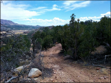
Photo Submitted 4/10/2016 (Thanks!)
Seep Springs Trail Photo
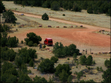
Photo Submitted 4/12/2016 (Thanks!)
Seep Springs Trail Photo
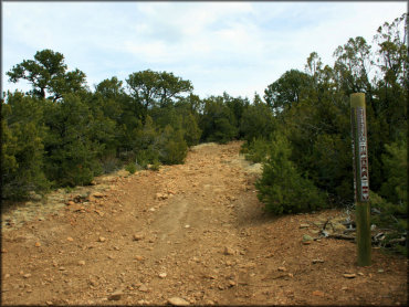
Photo Submitted 4/12/2016 (Thanks!)
Seep Springs Trail Photo
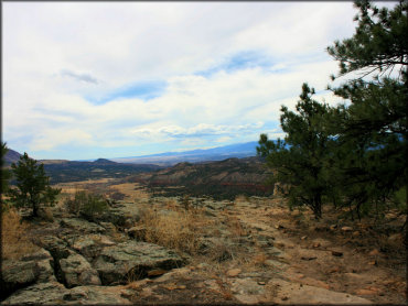
Photo Submitted 4/12/2016 (Thanks!)
Seep Springs Trail Photo
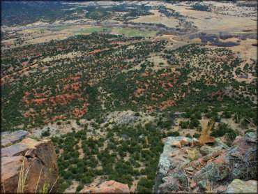
Photo Submitted 4/12/2016 (Thanks!)
Seep Springs Trail Photo
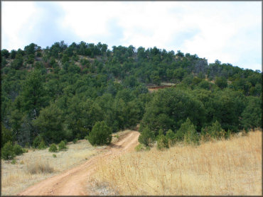
Photo Submitted 4/12/2016 (Some great shots. Thank You!)
RIDER COMMENTS & REVIEWS