 |
      |
| Home > Idaho > Canfield Mountain |
Canfield Mountain Trail System
Wednesday, August 20, 2025
| Other Names | Canfield Trail System, Coeur d'Alene National Forest, Kelly Mountain, West Canfield Butte, Huckleberry Mountain, Skitwish Peak, Jump Trail, Cave Trail, Canefield |
| Last Known Status | Open |
The Canfield Mountain Trail System offers about 30 miles of single-track motorcycle trails with nice views of Hayden Lake. The trails marked with numbers that run north-south present more of a challenge while the trails marked with letters running east-west are fairly mild.
The terrain consists of steep drop-offs, rocky sections and scattered tree roots. A large portion of this trail system consists of narrow single track but Trail #1562 is open to ATVs that are 50 inches or less in width. Look to nearby Coeur d'Alene Lake and Lake Pend Oreille for boating and swimming opportunities.
REGULATIONS
| Permit Required | Yes | Idaho OHV Registration Sticker |
| Dates Open | Year-Round | |
| Other ATV Stickers Accepted | No | A non-resident registration sticker must be purchased. (As of January 2020, Idaho no longer honors stickers from other states.) |
| Spark Arrestor | Yes | A spark arresting exhaust silencer or end cap is required for all vehicles. |
| Noise Limit | Yes (96 dB) | |
| Whip Flags | Not Required | |
| Maximum Vehicle Width | ||
 Motorcycles & Dirt Bikes Motorcycles & Dirt Bikes | Permitted | |
 ATVs ATVs | Some Areas | Not Recommended permitted on Trail 1562 |
 UTV & SXS UTV & SXS | Some Areas | Not Recommended permitted on Trail 1562 |
 4x4 & Jeeps (registered) 4x4 & Jeeps (registered) | Some Areas | Not Recommended permitted on Trail 1562 |
| Dune Buggy & Sand Rail 4x4 (unregistered) | Prohibited | |
| 2 Stroke Engines | No Restriction | |
| MX Helmet Required | Youth Only | required for persons under 18 by state law (RiderPlanet strongly recommends helmets for all riders.) |
 Camping Camping | ||
 Campfires Campfires | ||
| Night Riding | Unknown | |
| Trail Blazing | Prohibited | keep vehicle on trail |
| Alcohol | No Restriction | |
| Rule Enforcement | Few/Periodic |
TERRAIN
| Approx Size | 12,800 acres (20 sq mi) | |
| Miles Of Trail | 32 | |
| Climate Type | Forest | |
| Elevation | 2250 to 4250 ft. | |
| Trail Maintenance | Marked, Not Rated, Not Maintained | |
| Loose Dirt |  Some Some | |
| Hard Pack | Some | |
| Sand |  None None | |
| Mud |  Little Little | |
| Dust | Some | |
| Rocks | Some | |
| Trees |  Many Many | |
| Steep Hills | Some | |
| Water Crossings |  Few Few | |
| Small Jumps | Few | |
| Berms | Some | |
| Sand/Gravel Pits | None | |
| Single Track | Some | |
| Roads | Few | |
| Intersections | Some | |
| Rider Traffic | Some | |
| Shade | Many | |
| Ranges/Gunfire | Few | |
| Hazards | Few | (hazards assumed marked but use caution) |
 Novice Novice | Some | |
 Amateur Amateur |  Mostly Mostly | |
 Expert Expert | Little |
TYPE OF AREA
| Area | Motorized Trails |
| Land | National Forest |


KEY SERVICES
 Gasoline Gasoline | 1-5 Miles (SW) | Coeur d'Alene |
| Diesel | 1-5 Miles (SW) | Coeur d'Alene |
 Water Water | 1-5 Miles (SW) | Coeur d'Alene |
 RV Hookup RV Hookup | 1-5 Miles (S) | Cedar Motel & RV Park (208) 664-2278 |
 RV Disposal RV Disposal | 1-5 Miles (S) | Cedar Motel & RV Park (208) 664-2278 |
| Campground | 20-30 Miles (NE) | Molkins Bay Campround |
 Conv Store Conv Store | 5-20 Miles (SW) | Sherman IGA (208) 664-9992 |
FEES & PASSES
| Parking | (None) |
| Entry | (None) |
| Riding | (None) |
| Camping | (None) |
RATINGS
| Pros | single track, beautiful forest scenery, nearby lakes |
| Cons | steep drop-offs, some rocky sections |
| Our Rating |  Very Good Very Good |
| Recommended Stay | 1-2 Days Summer/Fall |
| Comments | (Scroll Down For Rider Reviews & Comments) |
DRIVING DIRECTIONS
| Nearest City | Coeur d'Alene, ID | ||
| Address | Nettleton Gulch Road, Coeur d'Alene, ID 83814 | ||
| From: Coeur d'Alene, ID
1) Take I-90 to Exit 14 2) At end of ramp turn west on E. Hazel Avenue 3) At T-intersection turn right (north) on N 15th Street, continue about 1 mile 4) Turn right (east) on E. Nettleton Gulch Road 5) Continue about 2 miles 6) Staging area will be on your right. Alternate Driving Directions: From: Coeur d'Alene, ID 1) Take I-90 to Exit 15 2) At base of ramp turn right (east) on E. Sherman Avenue 3) Proceed about 5 1/2 miles to the staging area. |


OFFICIAL CONTACTS
| Contact Info | Coeur d'Alene National Forest - Coeur d'Alene River District 2502 E. Sherman Avenue Coeur D'alene, ID 83814-5899 (208) 664-2318 mailroom_r1_idaho_panhandle@fs.fed.us www.fs.usda.gov |
| Contact Info | Idaho Parks And Recreation 5657 E Warm Springs Ave Boise, ID 83716 (208) 334-4197 reghelpline@idpr.idaho.gov parksandrecreation.idaho.gov |
| Comment | Idaho OHV Sticker Info |
Canfield Mountain Trail Photo
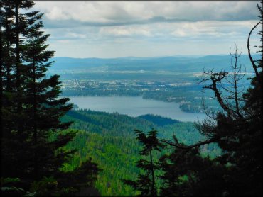
Photo Submitted 7/15/2014 (Thanks!)
Canfield Mountain Trail Photo
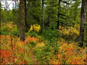
Photo Submitted 2/15/2017 (Thanks!)
Canfield Mountain Trail Photo
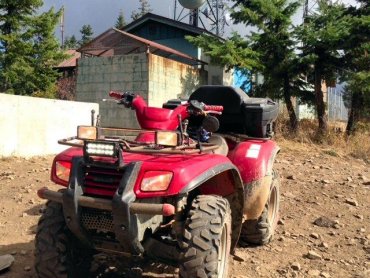
Photo Submitted 7/13/2015 (Thanks!)
Canfield Mountain Trail Photo
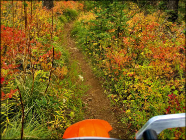
Photo Submitted 2/15/2017 (Thanks!)
Canfield Mountain Trail Photo
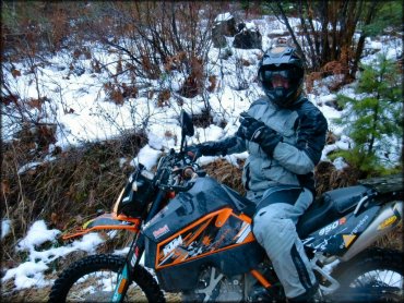
Photo Submitted 11/20/2012 (Thanks!)
RIDER COMMENTS & REVIEWS