 |
      |
| Home > Idaho > Independence Creek |
Independence Creek Trail System
Tuesday, March 31, 2026
| Other Names | Independence Trail #22, Ermine Ridge Trail #413, East Declaration Trail #416, Coeur d'Alene National Forest, Independence Creek, Faset Peak, Tepee Creek, Gold Creek, Gold Creek Lodge |
| Last Known Status | Open |
This single track trail system is surrounded by deep forest with numerous shallow creek crossings. The trails are mostly smooth, fast and narrow with some bridge crossings.
The trails are usually open for riding around April until the first snowfall, which is usually around late September. The forest is home to numerous wildlife that consists of badgers, cougars, elk and black bear.
RVs and travel trailers are not recommended because the access road is extremely long and winding and the parking area is small. Boating and swimming opportunities can be found at nearby Lake Pend Oreille and Hayden Lake.
REGULATIONS
| Permit Required | Yes | Idaho OHV Registration Sticker |
| Dates Open | April - September 7 | |
| Other ATV Stickers Accepted | No | A non-resident registration sticker must be purchased. (As of January 2020, Idaho no longer honors stickers from other states.) |
| Spark Arrestor | Yes | A spark arresting exhaust silencer or end cap is required for all vehicles. |
| Noise Limit | Yes (96 dB) | |
| Whip Flags | Not Required | |
| Maximum Vehicle Width | ||
 Motorcycles & Dirt Bikes Motorcycles & Dirt Bikes | Permitted | |
 ATVs ATVs | Prohibited | |
 UTV & SXS UTV & SXS | Prohibited | |
 4x4 & Jeeps (registered) 4x4 & Jeeps (registered) | Prohibited | |
| Dune Buggy & Sand Rail 4x4 (unregistered) | Prohibited | |
| 2 Stroke Engines | No Restriction | |
| MX Helmet Required | Youth Only | required for persons under 18 by state law (RiderPlanet strongly recommends helmets for all riders.) |
 Camping Camping | ||
 Campfires Campfires | ||
| Night Riding | Unknown | |
| Trail Blazing | Prohibited | keep on designated trails |
| Alcohol | No Restriction | |
| Rule Enforcement | Few/Periodic |
TYPE OF AREA
| Area | Motorized Trails |
| Land | National Forest |
FEES & PASSES
| Parking | (None) |
| Entry | (None) |
| Riding | (None) |
| Camping | (None) |
RATINGS
| Pros | many water crossings, deep forest scenery, wildlife viewing opportunities, single track only |
| Cons | not recommended for RV's or long trailers, no designated parking area |
| Our Rating |  Very Good Very Good |
| Recommended Stay | 1-2 Days Summer |
| Comments | (Scroll Down For Rider Reviews & Comments) |
DRIVING DIRECTIONS
| Nearest City | Hayden, ID | ||
| From: Hayden, ID
1) Take Hwy 95 North about 10 miles 2) Turn right (east) on E. Bunco Road 3) Continue about 2 1/2 miles 4) Turn left (north) to stay on E. Bunco Road 5) Proceed about 1 mile 6) Turn right (east) to stay on E. Bunco Road 7) Continue about 15 1/2 miles (E. Bunco Road turns into FS 332) 8) Trailhead starts on Weber Road. |

OFFICIAL CONTACTS
| Contact Info | Coeur D'alene River Ranger District 2502 E. Shermon Ave Coeur D'alene, ID 83814-5899 (208) 664-2318 mailroom_r1_idaho_panhandle@fs.fed.us www.fs.usda.gov |
| Contact Info | Idaho Parks And Recreation 5657 E. Warm Springs Ave Boise, ID 83716 (208) 334-4197 reghelpline@idpr.idaho.gov parksandrecreation.idaho.gov |
| Comment | Idaho OHV Sticker Info |
| Contact Info | Gold Creek Lodge 8754 Forest Service Loop Road #278 Lakeview, ID 83803 (208) 222-7669 info@goldcreeklodge.com goldcreeklodge.com |
Independence Creek Trail Photo
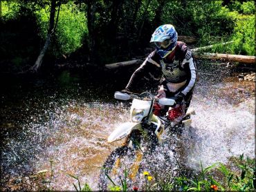
Photo Submitted 8/25/2015 (Thanks!)
ADD PHOTOS
TERRAIN
| Approx Size | 19,200 acres (30 sq mi) | |
| Miles Of Trail | 20 | |
| Climate Type | Forest | |
| Elevation | 2900 to 5000 ft. | |
| Trail Maintenance | Marked, Not Rated, Heavily Maintained | |
| Loose Dirt |  Little Little | |
| Hard Pack |  Some Some | |
| Sand |  None None | |
| Mud | Little | |
| Dust | Little | |
| Rocks | Some | |
| Trees |  Many Many | |
| Steep Hills |  Few Few | |
| Water Crossings | Many | |
| Small Jumps | Few | |
| Large Jumps | None | |
| Berms | Some | |
| Sand/Gravel Pits | None | |
| Single Track | Some | |
| Roads | Few | |
| Intersections | Some | |
| Rider Traffic | Some | |
| Shade | Many | |
| Ranges/Gunfire | Few | |
| Hazards | Few | (hazards assumed marked but use caution) |
 Novice Novice | Some | |
 Amateur Amateur |  Mostly Mostly | |
 Expert Expert | Little |


KEY SERVICES
 Gasoline Gasoline | 5-20 Miles (S) | Exxon (208) 772-4211 |
| Diesel | 5-20 Miles (S) | Hayden |
 Water Water | 5-20 Miles (S) | Hayden |
 RV Hookup RV Hookup | 5-20 Miles (NW) | Farragut State Park (208) 683-2425 |
 RV Disposal RV Disposal | 5-20 Miles (NW) | Farragut State Park (208) 683-2425 |
| Campground | 20-30 Miles (SE) | Big Hank Campground |
 Conv Store Conv Store | 5-20 Miles (SE) | Super Ore Foods (208) 772-5722 |
RIDER COMMENTS & REVIEWS