 |
      |
| Home > Idaho > Pleasant Valley |
Pleasant Valley Road OHV Area
Saturday, May 10, 2025
| Other Names | Indian Creek, Sand Creek, Snake River Plateau, Orchard Training Area |
| Last Known Status | Open |
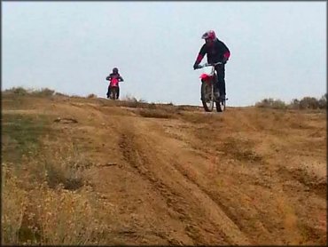
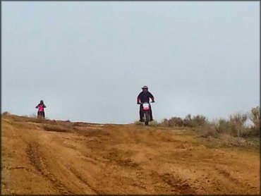
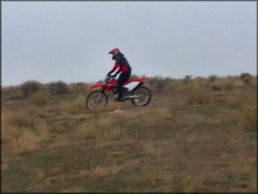
This large open area offers miles of mostly hard pack and wide desert trails with light elevation changes. Vegetation is sparse and mainly conisists of various scrub brush. The area is open year-round but the best time to visit is during the spring and fall months.
The area is a popular place to go for target shooting and while there is no fee to ride the trails are not marked or signed. There are no amenities so come prepared.
REGULATIONS
| Permit Required | Yes | Idaho OHV Registration Sticker |
| Dates Open | Year-Round | |
| Other ATV Stickers Accepted | No | A non-resident registration sticker must be purchased. (As of January 2020, Idaho no longer honors stickers from other states.) |
| Spark Arrestor | Yes | A spark arresting exhaust silencer or end cap is required for all vehicles. |
| Noise Limit | Yes | |
| Whip Flags | Not Required | |
| Maximum Vehicle Width | No Restriction | |
 Motorcycles & Dirt Bikes Motorcycles & Dirt Bikes | Permitted | |
 ATVs ATVs | Permitted | |
 UTV & SXS UTV & SXS | Permitted | |
 4x4 & Jeeps (registered) 4x4 & Jeeps (registered) | Permitted | |
| Dune Buggy & Sand Rail 4x4 (unregistered) | Permitted | |
| 2 Stroke Engines | No Restriction | |
| MX Helmet Required | Youth Only | required for persons under 18 by state law (RiderPlanet strongly recommends helmets for all riders.) |
 Camping Camping | No Restriction | (camp anywhere) |
 Campfires Campfires | ||
| Night Riding | Unknown | |
| Rule Enforcement |
Advertisement
TYPE OF AREA
| Area | Motorized Trails |
| Land | BLM |
FEES & PASSES
| Parking | (None) |
| Entry | (None) |
| Riding | (None) |
| Camping | (None) |
RATINGS
| Our Rating |  Good Good |
| Recommended Stay | Full Day |
| Comments | (Scroll Down For Rider Reviews & Comments) |
DRIVING DIRECTIONS
| Nearest City | Owyhee, ID | ||
| Address | Pleasant Valley Road, Owyhee, ID 89832 | ||
| From: Boise, ID
1) Take I-84 to Exit 52 2) Turn left (south) onto Orchard Street, continue 2 miles 3) Turn right (south) onto Pleasant Valley Road, continue about 11 miles 4) Staging area is on the left (east). |


OFFICIAL CONTACTS
| Contact Info | BLM - Owyhee Field Office 20 First Avenue West Marsing, ID 83639 (208) 896-5912 blm_id_owyheeoffice@blm.gov www.blm.gov |
| Contact Info | Idaho Parks And Recreation 5657 E. Warm Springs Ave Boise, ID 83716 (208) 334-4197 reghelpline@idpr.idaho.gov idahostateparks.reserveamerica.com |
| Comment | Idaho OHV Sticker Info |
Pleasant Valley Trail Photo
Pleasant Valley Trail Photo
Pleasant Valley Trail Photo
ADD PHOTOS
TERRAIN
| Approx Size | 2,560 acres (4 sq mi) | |
| Miles Of Trail | 25 | |
| Climate Type | Desert | |
| Elevation | 2900 to 3000 ft. | |
| Trail Maintenance | Unknown | |
| Loose Dirt |  Some Some | |
| Hard Pack |  Mostly Mostly | |
| Sand |  Little Little | |
| Mud | Little | |
| Dust | Some | |
| Rocks | Little | |
| Trees |  None None | |
| Steep Hills |  Few Few | |
| Water Crossings | None | |
| Small Jumps | None | |
| Large Jumps | None | |
| Berms | Some | |
| Sand/Gravel Pits | None | |
| Single Track | Some | |
| Roads | Some | |
| Intersections | Some | |
| Rider Traffic | Few | |
| Shade | None | |
| Ranges/Gunfire |  Many Many | |
| Hazards | Few | (hazards assumed marked but use caution) |
 Novice Novice | Some | |
 Amateur Amateur | Mostly | |
 Expert Expert | Little |
GPS POINTS


KEY SERVICES
 Gasoline Gasoline | 5-20 Miles (N) | Shell Gas Station (208) 336-0250 |
| Diesel | 5-20 Miles (N) | Shell Gas Station (208) 336-0250 |
 Water Water | 5-20 Miles (NE) | Mountain View RV Park (208) 345-4141 |
 RV Hookup RV Hookup | 5-20 Miles (NE) | Mountain View RV Park (208) 345-4141 |
 RV Disposal RV Disposal | 5-20 Miles (NE) | Mountain View RV Park (208) 345-4141 |
| Campground | 20-30 Miles (SW) | Celebration Park Campground (208) 455-6022 |
 Conv Store Conv Store | 5-20 Miles (N) | Shell Gas Station (208) 336-0250 |
RIDER COMMENTS & REVIEWS