 |
      |
| Home > Idaho > WARP Racing |
WARP Racing
Saturday, May 10, 2025
| Other Names | Snake River |
| Last Known Status | Closed |
This motocross track appears to be closed, but if you know better than send us a support e-mail and we will update this page pronto.
REGULATIONS
| Permit Required | No | |
| Dates Open | Closed | |
| Spark Arrestor | No | A spark arresting exhaust silencer or end cap is not required but is always recommended. |
| Noise Limit | No | |
| Whip Flags | Not Required | |
| Maximum Vehicle Width | ||
 Motorcycles & Dirt Bikes Motorcycles & Dirt Bikes | Prohibited | |
 ATVs ATVs | Prohibited | |
 UTV & SXS UTV & SXS | Prohibited | |
 4x4 & Jeeps (registered) 4x4 & Jeeps (registered) | Prohibited | |
| Dune Buggy & Sand Rail 4x4 (unregistered) | Prohibited | |
| 2 Stroke Engines | Prohibited | |
| MX Helmet Required | Yes | |
 Camping Camping | Some Areas | |
 Campfires Campfires | ||
| Night Riding | Unknown | |
| Rule Enforcement |
Advertisement
TYPE OF AREA
| Area | MX Track |
| Land | Privately Owned / Commercial |
MX TRACK 
| Features | Public |
| Max Engine Size | No Maximum |
| Min Engine Size | No Minimum |
FEES & PASSES
| Parking | (None) |
| Entry | (None) |
| Riding | Yes ($20.00 per rider) |
| Camping | Yes Tent: $20.00 RV: $20.00 Addtl. Vehicle: $0.00 |
RATINGS
| Our Rating |  Good Good |
| Recommended Stay | Full Day |
| Comments | (Scroll Down For Rider Reviews & Comments) |
DRIVING DIRECTIONS
| Nearest City | Burley, ID | ||
| Address | 100 N 100 E, Burley, ID 83318 | ||
| From: Twin Falls, ID
1) Take I-84 East to Exit 208 2) Turn right (south) onto Hwy 27/Overland Ave, continue about 2 miles 3) Turn left (east) onto Main Street, continue about 1 mile 4) Turn left (north) onto Highland Ave, continue .25 miles 5) Turn right (east) between the Railroad Tracks and onto the gravel road, follow signs toward the park. |

OFFICIAL CONTACTS
WARP Racing Track Photo
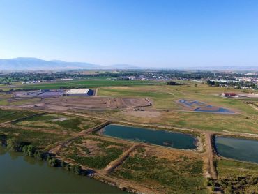
Photo Submitted 1/14/2016 (Thanks!)
ADD PHOTOS
TERRAIN
| Approx Size | 110 acres | |
| Climate Type | Urban/man-made | |
| Elevation | 4125 to 4150 ft. | |
| Loose Dirt |  Mostly Mostly | |
| Hard Pack |  Little Little | |
| Sand | Little | |
| Mud | Little | |
| Dust |  Some Some | |
| Rocks |  None None | |
| Trees | None | |
| Steep Hills | None | |
| Water Crossings | None | |
| Small Jumps |  Many Many | |
| Large Jumps | Some | |
| Berms |  All All | |
| Sand/Gravel Pits | None | |
| Single Track | None | |
| Roads |  Few Few | |
| Shade | None | |
| Hazards | Few | (hazards assumed marked but use caution) |
 Novice Novice | Some | |
 Amateur Amateur | Mostly | |
 Expert Expert | Little |


KEY SERVICES
 Gasoline Gasoline | 1-5 Miles (S) | Smiths Gas Station (208) 678-2253 |
| Diesel | 1-5 Miles (S) | Smiths Gas Station (208) 678-2253 |
 Water Water | 1-5 Miles (E) | Heyburn Riverside RV Park (208) 679-8610 |
 RV Hookup RV Hookup | 1-5 Miles (E) | Heyburn Riverside RV Park (208) 679-8610 |
 RV Disposal RV Disposal | 1-5 Miles (E) | Heyburn Riverside RV Park (208) 679-8610 |
| Campground | 1-5 Miles (E) | Heyburn Riverside RV Park (208) 679-8610 |
 Conv Store Conv Store | 1-5 Miles (S) | Smiths Gas Station (208) 678-2253 |
RIDER COMMENTS & REVIEWS