 |
      |
| Home > Kansas > Turkey Trail |
Turkey Trail
Wednesday, August 20, 2025
| Other Names | Cimarron National Grasslands, Cottonwood Picnic Grounds, Cimarron River, Wilburton Crossing |
| Last Known Status | Open |
This part of the Cimarron National Grassland offers a 10.5 mile long ATV trail that follows the Cimarron River. The trail is mostly hard packed and wide and runs in an east to west direction but may get a bit rugged and overgrown as you head east past the Cimarron Campground.
A makeshift motocross track can be found on the opposite side of the river, but note that the track is only open to machines that are 50 inches or less in width. There are also several miles of old dirt roads that are open to all vehicle types.
The trail can be accessed at the Cottonwood Picnic Area or at the Cimarron Campground. This area is open year-round but the best time to visit is during the spring or fall months.
REGULATIONS
| Permit Required | No | |
| Dates Open | Year-Round | |
| Other ATV Stickers Accepted | Unknown | |
| Spark Arrestor | Yes | A spark arresting exhaust silencer or end cap is required for all vehicles. |
| Noise Limit | Yes (96 dB) | |
| Whip Flags | Not Required | |
| Maximum Vehicle Width | No Restriction | |
 Motorcycles & Dirt Bikes Motorcycles & Dirt Bikes | Permitted | |
 ATVs ATVs | Permitted | |
 UTV & SXS UTV & SXS | Permitted | |
 SUVs & Jeeps (registered) SUVs & Jeeps (registered) | Some Areas | not permitted on mx track |
| Dune Buggy & Sand Rail 4x4 (unregistered) | Some Areas | not permitted on mx track |
| 2 Stroke Engines | No Restriction | |
 Camping Camping | Some Areas | (camp in developed sites only) |
 Campfires Campfires | Some Areas | (permitted in developed campsites only) |
| Night Riding | Unknown | |
| Trail Blazing | Prohibited | stay on trails |
| Rule Enforcement |
TYPE OF AREA
| Area | Motorized Trails, MX Track |
| Land | National Forest |

| Features | Public |
| Max Engine Size | No Maximum |
| Min Engine Size | No Minimum |
| Comment | makeshift mx track |
FEES & PASSES
| Parking | (None) |
| Entry | (None) |
| Riding | (None) |
| Camping | Yes Tent: $7.00 RV: $7.00 Addtl. Vehicle: $0.00 Cimarron Campground Fee |
RATINGS
| Our Rating |  Good Good |
| Recommended Stay | Full Day |
| Comments | (Scroll Down For Rider Reviews & Comments) |
DRIVING DIRECTIONS
| Nearest City | Elkhart, KS | ||
| From: Elkhart, KS
1) Take SR-27 North about 9 miles 2) Turn right (east) on FS Road 700.2, stage at Cottonwood Picnic Area. For Cimarron Campground: 3) Continue east past Cottonwood Picnic Area on FS Road 700.2 about 4 miles 4) Campground entrance is on the left (north). |

OFFICIAL CONTACTS
| Contact Info | Cimarron National Grassland 242 East Highway 56 Elkhart, KS 67950 (620) 697-4621 mailroom_r2_pike_san_isabel@fs.fed.us www.fs.usda.gov |
Turkey Trail OHV Area Photo
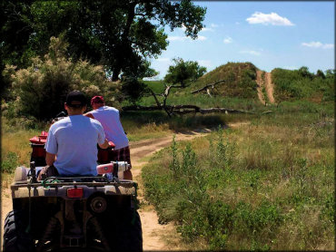
Photo Submitted 6/20/2016 (Thanks!)
ADD PHOTOS
TERRAIN
| Miles Of Trail | 10 | |
| Climate Type | Plains | |
| Elevation | 3300 to 3400 ft. | |
| Trail Maintenance | Marked, Not Rated, Lightly Maintained | |
| Loose Dirt |  Little Little | |
| Hard Pack |  Mostly Mostly | |
| Sand | Little | |
| Mud | Little | |
| Dust |  Some Some | |
| Rocks | Little | |
| Trees | Some | |
| Steep Hills |  Few Few | |
| Water Crossings | Some | |
| Small Jumps | Some | located at motocross track |
| Large Jumps | Few | located at motocross track |
| Berms | Few | |
| Sand/Gravel Pits |  None None | |
| Single Track | None | |
| Roads | Some | |
| Shade | Few | |
| Hazards | Few | (hazards assumed marked but use caution) |
 Novice Novice | Some | |
 Amateur Amateur | Mostly | |
 Expert Expert | Little |


KEY SERVICES
 Gasoline Gasoline | 5-20 Miles (S) | Anadarko Petroleum Corp (620) 697-2188 |
| Diesel | 5-20 Miles (S) | Anadarko Petroleum Corp (620) 697-2188 |
 Water Water | On Site | |
 RV Hookup RV Hookup | 5-20 Miles (SE) | Prairie RV Park & Car Wash (620) 360-1095 |
 RV Disposal RV Disposal | 5-20 Miles (SE) | Prairie RV Park & Car Wash (620) 360-1095 |
| Campground | On Site | Cimarron Campground (620) 697-4621 |
 Conv Store Conv Store | 5-20 Miles (S) | Anadarko Petroleum Corp (620) 697-2188 |
RIDER COMMENTS & REVIEWS