 |
      |
| Home > Maine > Houlton To Phair Junction |
Houlton To Phair Junction ATV Trail
Saturday, May 10, 2025
| Other Names | North Street, Southern Bangor and Aroostook Trail |
| Last Known Status | Open |
This multiple use trail is actually an old railroad bed that consists of hard packed dirt and crushed gravel with light elevation changes, making it a good choice for beginners. The trail is linear and heads in a north and south direction while offering some nice views of the surrounding farmlands, rivers and lakes.
There are several access points with some picnic areas along the route, but the main staging area is located at the Maine Visitor Information Center in Houlton, but the actual trailhead is located behind a grocery store off Ludlow Road. From here the trail is about 40 miles long each way, but there are plenty of opportunities to get food and gas when riding by nearby towns.
The trail is open to motorized use from late spring to early fall. During the winter months snowmobiles are permitted.
REGULATIONS
| Permit Required | Yes | Maine ATV Registration |
| Dates Open | Open daily except during mud season. | |
| Other ATV Stickers Accepted | No | ATVs and motorcycles must be registered in Maine. No reciprocity with other states. |
| Spark Arrestor | Yes | A spark arresting exhaust silencer or end cap is required for all vehicles. |
| Noise Limit | Yes (96 dB) | |
| Whip Flags | Not Required | |
| Maximum Vehicle Width | Yes (60 inches) | has entrance gate or posts |
 Motorcycles & Dirt Bikes Motorcycles & Dirt Bikes | Permitted | |
 ATVs ATVs | Permitted | |
 UTV & SXS UTV & SXS | Permitted | (maximum width 60 inches) |
 SUVs & Jeeps (registered) SUVs & Jeeps (registered) | Prohibited | |
| Dune Buggy & Sand Rail 4x4 (unregistered) | Prohibited | |
| 2 Stroke Engines | No Restriction | |
 Camping Camping | ||
 Campfires Campfires | ||
| Night Riding | Unknown | |
| Trail Blazing | Prohibited | riders must stay on trail |
| Rule Enforcement |
TYPE OF AREA
| Area | Motorized Trails |
| Land | City Land, County Land |
FEES & PASSES
| Parking | (None) |
| Entry | (None) |
| Riding | (None) |
| Camping | (None) |
RATINGS
| Our Rating |  |
| Recommended Stay | Full Day |
| Comments | (Scroll Down For Rider Reviews & Comments) |
DRIVING DIRECTIONS
| Nearest City | Houlton, ME | ||
| Address | Ludlow Road, Houlton, ME 04730 | ||
| From: Bangor, ME
1) Take I-95 to Exit 302 2) Turn left (north) off the exit ramp onto North Street, continue .2 miles 3) Turn left (west) onto Ludlow Road, continue .2 miles 4) Look for Maine Visitor Information Center, park here. |


OFFICIAL CONTACTS
| Contact Info | Maine Bureau of Parks And Lands - ATV Program 22 State House Station Augusta, ME 04333-0022 (207) 287-3821 dacf@maine.gov www.maine.gov |
| Contact Info | Maine Department of Inland Fisheries And Wildlife 284 State Street Augusta, ME 04333-0041 (207) 287-8000 moses.informe.org |
| Comment | Maine OHV Permit Info |
Houlton To Phair Junction Trail Photo
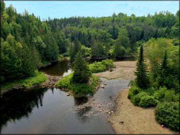
Photo Submitted 7/29/2019 (Thanks!)
ADD PHOTOS
TERRAIN
| Miles Of Trail | 40 | |
| Climate Type | Forest | |
| Elevation | 350 to 400 ft. | |
| Trail Maintenance | Marked, Not Rated, Lightly Maintained | |
| Loose Dirt |  Little Little | |
| Hard Pack |  Mostly Mostly | |
| Sand |  None None | |
| Mud | Little | |
| Dust |  Some Some | |
| Rocks | Little | |
| Trees |  Many Many | |
| Steep Hills | None | |
| Water Crossings |  Few Few | |
| Small Jumps | None | |
| Large Jumps | None | |
| Berms | None | |
| Sand/Gravel Pits | None | |
| Single Track | None | |
| Roads | Mostly | |
| Shade | Many | |
| Hazards | Few | (hazards assumed marked but use caution) |
 Novice Novice | Some | |
 Amateur Amateur | Mostly | |
 Expert Expert | Little |
GPS POINTS


KEY SERVICES
 Gasoline Gasoline | 1-5 Miles (E) | Shell (207) 532-0785 |
| Diesel | 1-5 Miles (E) | Shell (207) 532-0785 |
 Water Water | 1-5 Miles (N) | My Brother's Place Campground (207) 532-6739 |
 RV Hookup RV Hookup | 1-5 Miles (N) | My Brother's Place Campground (207) 532-6739 |
 RV Disposal RV Disposal | 1-5 Miles (N) | My Brother's Place Campground (207) 532-6739 |
| Campground | 1-5 Miles (N) | My Brother's Place Campground (207) 532-6739 |
 Conv Store Conv Store | 1-5 Miles (E) | Shell (207) 532-0785 |
RIDER COMMENTS & REVIEWS