 |
      |
| Home > Maine > Mount Agamenticus |
Mount Agamenticus
Saturday, May 10, 2025
| Other Names | Mt. Agamenticus, Mount A, Hoopers Swamp, Second Hill, 2nd Hill, Third Hill, Chicks Brook, Norman Hill, Kenyon Hill, Hanscom Hill, Braceys Swamp, Welches Pond, Big A, Sasanoa’s Mount |
| Last Known Status | Open |
This area offers 8 miles of multiple use trails with thick forest scenery can be found at this recreation area. The Cedar Trailhead provides access to the Norman Mill, Notch, and Great Marsh trails which are open to ATVs.
The trails are shared by hikers, bikers, equestrians and ATV riders so use extra caution. Some sections consist of loose rocks, moderate elevation changes and tree roots.
Wild turkey, bobcats, black bear and great horned owls inhabit the area. Camping and campfires are not permitted. If you are bringing a pet be sure to keep it leashed and on the trail. The hunters here sometimes use traps baited with meat.
REGULATIONS
| Permit Required | Yes | Maine ATV Registration |
| Dates Open | daily dawn to dusk | |
| Spark Arrestor | Yes | A spark arresting exhaust silencer or end cap is required for all vehicles. |
| Noise Limit | Yes (96 dB) | |
| Whip Flags | Not Required | |
| Maximum Vehicle Width | Yes (60 inches) | |
 Motorcycles & Dirt Bikes Motorcycles & Dirt Bikes | Some Areas | |
 ATVs ATVs | Some Areas | |
 UTV & SXS UTV & SXS | Some Areas | (maximum width 60 inches) |
 SUVs & Jeeps (registered) SUVs & Jeeps (registered) | Prohibited | |
| Dune Buggy & Sand Rail 4x4 (unregistered) | Prohibited | |
| 2 Stroke Engines | No Restriction | |
 Camping Camping | Prohibited | |
 Campfires Campfires | Prohibited | |
| Night Riding | No | trails open dawn to dusk |
| Trail Blazing | Prohibited | keep vehicle on trail |
| Alcohol | Prohibited | |
| Rule Enforcement |
TYPE OF AREA
| Area | Motorized Trails |
| Land | Private, Public |
FEES & PASSES
| Parking | (None) |
| Entry | (None) |
| Riding | (None) donations are appreciated |
| Camping | (None) |
RATINGS
| Our Rating |  Good Good |
| Recommended Stay | Half Day |
| Comments | (Scroll Down For Rider Reviews & Comments) |
DRIVING DIRECTIONS
| Nearest City | Cape Neddick, ME | ||
| From: Cape Neddick, ME
1) Take Hwy 1 south to Mountain Road 2) Turn right (west) on Mountain Road 3) Continue 3 miles 4) Veer left at fork 5) Continue 1 mile 6) Stay straight when you come to the Big A Road on the right. Take this road (it turns to dirt) to the Cedar Trailhead on the right (there’s a parking lot). |


OFFICIAL CONTACTS
| Contact Info | Mount Agamenticus Conservation Region 186 York Street York, ME 03909 (207) 361-1102 robin@agamenticus.org agamenticus.org |
| Contact Info | Maine Department of Inland Fisheries And Wildlife 284 State Street Augusta, ME 04333-0041 (207) 287-8000 moses.informe.org |
| Comment | Maine OHV Permit Info |
Mount Agamenticus Trail Photo
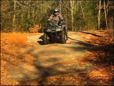
Photo Submitted 11/23/2014 (Nice shot. Thanks!)
ADD PHOTOS
TERRAIN
| Approx Size | 30,000 acres (47 sq mi) | |
| Miles Of Trail | 8 | |
| Climate Type | Forest | |
| Elevation | 300 to 700 ft. | |
| Trail Maintenance | Marked, Not Rated, Lightly Maintained | |
| Loose Dirt |  Some Some | |
| Hard Pack |  Little Little | |
| Sand |  None None | |
| Mud | Some | |
| Dust | None | |
| Rocks | Little | |
| Trees |  All All | |
| Steep Hills | Some | |
| Water Crossings | None | |
| Small Jumps | None | |
| Large Jumps | None | |
| Berms | None | |
| Sand/Gravel Pits | None | |
| Single Track | Some | |
| Roads |  Few Few | |
| Shade |  Many Many | |
| Hazards | Few | (hazards assumed marked but use caution) |
 Novice Novice | Some | |
 Amateur Amateur |  Mostly Mostly | |
 Expert Expert | Little |
GPS POINTS


KEY SERVICES
 Gasoline Gasoline | 5-20 Miles (W) | Cumberland Farms (207) 384-6269 |
| Diesel | 5-20 Miles (W) | Cumberland Farms (207) 384-6269 |
 Water Water | 5-20 Miles (SE) | Libby's Oceanside Camp (207) 363-4171 |
 RV Hookup RV Hookup | 5-20 Miles (SE) | Libby's Oceanside Camp (207) 363-4171 |
 RV Disposal RV Disposal | 5-20 Miles (SE) | Libby's Oceanside Camp (207) 363-4171 |
| Campground | 5-20 Miles (SE) | |
 Conv Store Conv Store | 5-20 Miles (W) | Cumberland Farms (207) 384-6269 |
RIDER COMMENTS & REVIEWS