 |
      |
| Home > Maryland > Garrett Trail System |
Garrett Trail System
Saturday, May 10, 2025
| Other Names | Snaggy Mountain Road, Lake Herrington, Lake Koshare, Murley Run Creek, Bull Gold Run Creek, Garrett State Forest, Briar Ridge, Herrington Lake, Lake Koshare |
| Last Known Status | Open |
This part of the Garrett State Forest offers an old logging road that is open to OHV use between mid March through mid December. The trail mainly consists of hard packed gravel with light elevation changes, making this a good place to explore on a dual sport motorcycle or 4x4.
The trail begins at the intersection of Cranesville Road and heads south about 3 miles along Snaggy Mountain Road and ends at the bridge near Herrington Lake.
Maple, cherry and oak trees make up this hardwood forest scenery and turkey, black bear and deer can be seen.
Overnight parking is not permitted at the staging area but nearby Swallow Falls State Park offers camping facilities.
REGULATIONS
| Permit Required | Yes | MD DNR Registraton Sticker |
| Dates Open | March 16 - December 15 | |
| Other ATV Stickers Accepted | Unknown | |
| Spark Arrestor | Yes | A spark arresting exhaust silencer or end cap is required for all vehicles. |
| Noise Limit | Yes (84 dB) | maximum sound level at 50' |
| Whip Flags | Not Required | |
| Maximum Vehicle Width | No Restriction | |
 Motorcycles & Dirt Bikes Motorcycles & Dirt Bikes | Permitted | |
 ATVs ATVs | Some Areas | |
 UTV & SXS UTV & SXS | Some Areas | |
 SUVs & Jeeps (registered) SUVs & Jeeps (registered) | Permitted | |
| Dune Buggy & Sand Rail 4x4 (unregistered) | Prohibited | |
| 2 Stroke Engines | No Restriction | |
 Camping Camping | ||
 Campfires Campfires | ||
| Night Riding | Unknown | |
| Trail Blazing | Prohibited | keep on the trail |
| Rule Enforcement |
TYPE OF AREA
| Area | Motorized Trails |
| Land | State Forest |
FEES & PASSES
| Parking | (None) |
| Entry | (None) |
| Riding | (None) |
| Camping | (None) |
RATINGS
| Our Rating |  |
| Recommended Stay | Full Day |
| Comments | (Scroll Down For Rider Reviews & Comments) |
DRIVING DIRECTIONS
| Nearest City | Oakland, MD | ||
| From: Friendsville, MD
1) Take SR-42 South about 4.3 miles 2) At intersection turn right on Bishoff Road, continue 2.2 miles 3) At intersection turn right (west) on Sang Run Road, continue 5.6 miles 4) At T-intersection turn left (south) on Cranesville Road, continue 5.5 miles 5) Turn right (west) on Snaggy Mountain Road, continue .25 miles 6) Staging area is on the right. |


OFFICIAL CONTACTS
| Contact Info | Garrett State Forest 1431 Potomac Camp Road Oakland, MD 21550 (301) 334-2038 socialmedia.dnr@maryland.gov dnr.maryland.gov |
| Contact Info | Maryland Department of Natural Resources dnr.maryland.gov |
| Comment | ORV Registration Info |
Garrett Trail System Photo
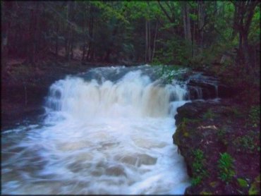
Photo Submitted 3/2/2015 (Thanks!)
Garrett Trail System Photo
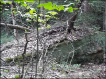
Photo Submitted 3/2/2015 (Thanks!)
ADD PHOTOS
TERRAIN
| Approx Size | 7,000 acres (11 sq mi) | |
| Miles Of Trail | 3 | |
| Climate Type | Forest | |
| Elevation | 2300 to 2500 ft. | |
| Trail Maintenance | Marked, Not Rated, Lightly Maintained | |
| Loose Dirt |  None None | |
| Hard Pack |  Mostly Mostly | |
| Sand | None | |
| Mud | None | |
| Dust |  Little Little | |
| Rocks | Little | |
| Trees |  All All | |
| Steep Hills | None | |
| Water Crossings | None | |
| Small Jumps | None | |
| Large Jumps | None | |
| Berms | None | |
| Sand/Gravel Pits | None | |
| Single Track | None | |
| Roads |  Few Few | |
| Shade |  Many Many | |
| Hazards | Few | (hazards assumed marked but use caution) |
 Novice Novice |  Some Some | |
 Amateur Amateur | Mostly | |
 Expert Expert | Little |
GPS POINTS


KEY SERVICES
 Gasoline Gasoline | 5-20 Miles (SE) | 7-11 (301) 334-1199 |
| Diesel | 5-20 Miles (SE) | 7-11 (301) 334-1199 |
 Water Water | 1-5 Miles (NE) | Swallow Falls State Park Campground (888) 432-2267 |
 RV Hookup RV Hookup | 1-5 Miles (NE) | Swallow Falls State Park Campground (888) 432-2267 |
 RV Disposal RV Disposal | 1-5 Miles (NE) | Swallow Falls State Park Campground (888) 432-2267 |
| Campground | 1-5 Miles (NE) | Swallow Falls State Park Campground (888) 432-2267 |
 Conv Store Conv Store | 5-20 Miles (SE) | 7-11 (301) 334-1199 |
RIDER COMMENTS & REVIEWS