 |
      |
| Home > Minnesota > Martineau |
Martineau Motorcycle Trails
Thursday, April 30, 2026
| Other Names | Paul Bunyan State Forest, Martineau Recreation Trails, Round River ATV Trail, Blue Trail, Steamboat Forest Road, Benedict Lake, Lester Lake, Bass Lakes, Eleventh Crow Wing Lake, Kramer Lake, Rickles Lake, Stompin Grounds Campground |
| Last Known Status | Open |
This part of the Paul Bunyan State Forest offers over 100+ miles of single track motorcycle trails that from many interconnecting loops. The trails consist of mostly loamy dirt with some sandy sections plus some rocky, rugged and rutted single track.
The forest is very hilly with numerous shallow ponds, which gives the trails a lot of natural flow and light to moderate elevation changes. The area is home to abundant wildlife that ranges from deer, moose, owls, ducks and bear.
Camping is permitted at the staging areas but there are no services so come prepared. Stompin Grounds Lodge and Camping is just a few miles south of the main staging area, which features full hookups, restrooms, hot showers, restaurant and bar plus direct trail access.
REGULATIONS
| Permit Required | Yes | MN OHV Permit |
| Dates Open | May - November 1 | |
| Other ATV Stickers Accepted | Unknown | |
| Spark Arrestor | Yes | A spark arresting exhaust silencer or end cap is required for all vehicles. |
| Noise Limit | Yes (96 dB) | OHMs not to exceed distance of 20 inches |
| Whip Flags | Not Required | |
| Maximum Vehicle Width | ||
 Motorcycles & Dirt Bikes Motorcycles & Dirt Bikes | Permitted | |
 ATVs ATVs | Prohibited | |
 UTV & SXS UTV & SXS | Prohibited | |
 SUVs & Jeeps (registered) SUVs & Jeeps (registered) | Prohibited | |
| Dune Buggy & Sand Rail 4x4 (unregistered) | Prohibited | |
| 2 Stroke Engines | No Restriction | |
| MX Helmet Required | Youth Only | required for operators under 18 by state law (RiderPlanet strongly recommends helmets for all riders.) |
 Camping Camping | ||
 Campfires Campfires | ||
| Night Riding | Unknown | |
| Trail Blazing | Prohibited | stay on trail |
| Rule Enforcement |
TERRAIN
| Approx Size | 150,113 acres (235 sq mi) | |
| Miles Of Trail | 107 | |
| Climate Type | Forest | |
| Elevation | 1400 to 1600 ft. | |
| Trail Maintenance | Marked, Not Rated, Lightly Maintained | |
| Loose Dirt |  Some Some | |
| Hard Pack |  Little Little | |
| Sand |  None None | |
| Mud | Little | |
| Dust | None | |
| Rocks | Little | |
| Trees |  All All | |
| Steep Hills |  Few Few | |
| Water Crossings | Few | |
| Small Jumps | None | |
| Large Jumps | None | |
| Berms | Some | |
| Sand/Gravel Pits | None | |
| Single Track |  Many Many | |
| Roads | Few | |
| Shade | All | |
| Hazards | Few | (hazards assumed marked but use caution) |
 Novice Novice | Little | |
 Amateur Amateur |  Mostly Mostly | |
 Expert Expert | Some |
TYPE OF AREA
| Area | Motorized Trails |
| Land | State Forest |
GPS POINTS


KEY SERVICES
 Gasoline Gasoline | 5-20 Miles (S) | Bunyan's Convenience (218) 652-3333 |
| Diesel | 5-20 Miles (S) | Bunyan's Convenience (218) 652-3333 |
 Water Water | 1-5 Miles (S) | Stompin Grounds Lodge and Camping (218) 652-2964 |
 RV Hookup RV Hookup | 1-5 Miles (S) | Stompin Grounds Lodge and Camping (218) 652-2964 |
 RV Disposal RV Disposal | 1-5 Miles (S) | Stompin Grounds Lodge and Camping (218) 652-2964 |
| Campground | 1-5 Miles (S) | Stompin Grounds Lodge and Camping (218) 652-2964 |
 Conv Store Conv Store | 5-20 Miles (S) | Blue Ox Market (218) 652-2145 |
FEES & PASSES
| Parking | (None) |
| Entry | (None) |
| Riding | (None) |
| Camping | (None) |
RATINGS
| Our Rating |  Good Good |
| Recommended Stay | Full Day |
| Comments | (Scroll Down For Rider Reviews & Comments) |
DRIVING DIRECTIONS
| Nearest City | Akeley, MN | ||
| From: Walker, MN
1) Take SR-34 West 9 miles 2) Turn right (north) on SR-64, continue 5.7 miles 3) Turn left (west) on Blue Trail, follow to staging area. |


OFFICIAL CONTACTS
| Contact Info | Paul Bunyan State Forest - Bemidji Area Office (218) 308-2372 info.dnr@state.mn.us www.dnr.state.mn.us |
| Contact Info | Paul Bunyan Forest Riders MC (218) 739-5525 trails@pbfriders.com pbfriders.com |
| Contact Info | Minnesota DNR License Bureau 500 Lafayette Road St. Paul, MN 55155 (888) 665-4236 info.dnr@state.mn.us www.dnr.state.mn.us |
| Contact Info | Stompin Grounds Lodge And Camping 26993 MN-64 Akeley, MN 56433 (218) 652-2964 www.stompingroundslodge.com |
| Comment | Nearby RV campground and restaurant. |
Martineau Trail Photo
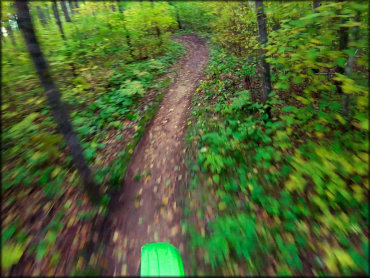
Photo Submitted 10/8/2018 (Thanks!)
Martineau Trail Photo
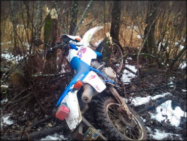
Photo Submitted 1/17/2014 (Thanks!)
Martineau Trail Photo
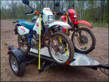
Photo Submitted 6/26/2013 (Thanks!)
Martineau Trail Photo
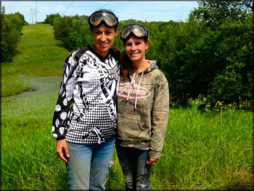
Photo Submitted 5/4/2015 (Thanks!)
RIDER COMMENTS & REVIEWS