 |
      |
| Home > Minnesota > Snake Creek |
Snake Creek OHV Trails
Thursday, April 30, 2026
| Other Names | Richard J. Dorer State Forest, Rattlesnake Ridge, East Indian Creek |
| Last Known Status | Open |
This state forest offers 13.5 miles of ATV trails that for several interconnecting loops. The trails are marked and offer a wide variety of terrain that ranges from hard packed dirt and gravel to deep rugged and muddy sections with chunky hill climbs.
The forest offers some rolling hills, which provides some light to moderate elevation changes. The top of some of the hills offer scenic overlooks of the surrounding valleys.
The main staging area off Township Road 152 has the most room and also features an informational kiosk, several sites with picnic tables, BBQ grills, a vault toilet and a large hand pump well. There is no fee charged to camp but sites are first come, first serve.
REGULATIONS
| Permit Required | Yes | MN OHV Permit |
| Dates Open | May - November 1 | |
| Other ATV Stickers Accepted | Unknown | |
| Spark Arrestor | Yes | A spark arresting exhaust silencer or end cap is required for all vehicles. |
| Noise Limit | Yes (96 dB) | OHMs not to exceed 96db at 20 inches, ATVs 99dB at 20 inches |
| Whip Flags | Not Required | |
| Maximum Vehicle Width | Yes (65 inches) | has entrance gate or posts |
 Motorcycles & Dirt Bikes Motorcycles & Dirt Bikes | Permitted | |
 ATVs ATVs | Permitted | |
 UTV & SXS UTV & SXS | Permitted | (maximum width 65 inches) |
 SUVs & Jeeps (registered) SUVs & Jeeps (registered) | Prohibited | |
| Dune Buggy & Sand Rail 4x4 (unregistered) | Prohibited | |
| 2 Stroke Engines | No Restriction | |
| MX Helmet Required | Youth Only | required for operators under 18 by state law (RiderPlanet strongly recommends helmets for all riders.) |
 Camping Camping | Some Areas | (camp in developed sites only) |
 Campfires Campfires | ||
| Night Riding | Unknown | |
| Trail Blazing | Prohibited | stay on designated trails |
| Rule Enforcement |
TERRAIN
| Approx Size | 3,200 acres (5 sq mi) | |
| Miles Of Trail | 13 | |
| Climate Type | Forest | |
| Elevation | 750 to 1000 ft. | |
| Trail Maintenance | Marked, Not Rated, Lightly Maintained | |
| Loose Dirt |  Little Little | |
| Hard Pack |  Some Some | |
| Sand | Little | |
| Mud |  Mostly Mostly | |
| Dust | Some | |
| Rocks | Little | |
| Trees |  All All | |
| Steep Hills |  None None | |
| Water Crossings |  Few Few | |
| Small Jumps | None | |
| Large Jumps | None | |
| Berms | Few | |
| Sand/Gravel Pits | None | |
| Single Track | Some | |
| Roads | Few | |
| Shade | Some | |
| Hazards | Few | (hazards assumed marked but use caution) |
 Novice Novice | Some | |
 Amateur Amateur | Mostly | |
 Expert Expert | Little |
TYPE OF AREA
| Area | Motorized Trails |
| Land | State Forest |


KEY SERVICES
 Gasoline Gasoline | 5-20 Miles (N) | Kwik Trip (507) 767-4768 |
| Diesel | 5-20 Miles (N) | Kwik Trip (507) 767-4768 |
 Water Water | 5-20 Miles (N) | Kwik Trip (507) 767-4768 |
 RV Hookup RV Hookup | 5-20 Miles (NE) | Pioneer Campsites Resort (651) 565-2242 |
 RV Disposal RV Disposal | 5-20 Miles (NE) | Pioneer Campsites Resort (651) 565-2242 |
| Campground | 5-20 Miles (NE) | Wabasha Municipal Campground (651) 565-4568 |
 Conv Store Conv Store | 5-20 Miles (N) | Kwik Trip (507) 767-4768 |
FEES & PASSES
| Parking | (None) |
| Entry | (None) |
| Riding | (None) |
| Camping | (None) |
RATINGS
| Our Rating |  Good Good |
| Recommended Stay | Full Day |
| Comments | (Scroll Down For Rider Reviews & Comments) |
DRIVING DIRECTIONS
| Nearest City | Kellogg, MN | ||
| From: Kellogg, MN
1) Take US-61 South 3 miles 2) Turn right (west) on Township Road 152, continue 1.5 miles 3) Staging area is on the left (south). |


OFFICIAL CONTACTS
| Contact Info | R. J. Dorer State Forest - Rochester Area Office 3555 9th Street NW, Suite 350 Rochester, MN 55901 (507) 206-2847 info.dnr@state.mn.us www.dnr.state.mn.us |
| Contact Info | Minnesota DNR License Bureau 500 Lafayette Road St. Paul, MN 55155 (888) 665-4236 info.dnr@state.mn.us www.dnr.state.mn.us |
| Comment | OHV Permit Info |
Snake Creek Trail Photo
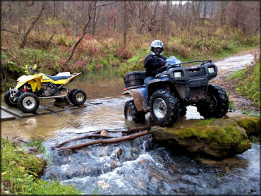
Photo Submitted 10/30/2016 (Thanks!)
Snake Creek Trail Photo
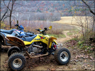
Photo Submitted 10/30/2016 (Thanks!)
Snake Creek Trail Photo
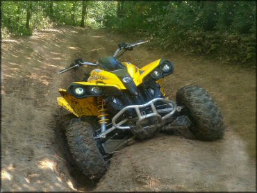
Photo Submitted 9/24/2011 (Thanks!)
Snake Creek Trail Photo
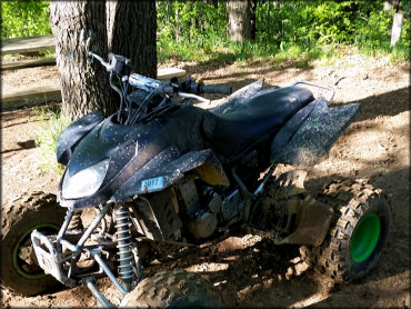
Photo Submitted 2/23/2016 (Thanks!)
RIDER COMMENTS & REVIEWS