 |
      |
| Home > Minnesota > Trout Valley |
Trout Valley Trails
Saturday, May 10, 2025
| Other Names | Richard J. Dorer State Forest, Trout Valley Creek, Adams Valley, Trout Valley, Whitewater Valley, Mississippi River Valley |
| Last Known Status | Open |
This part of the Richard J. Dorer State Forest has one long trail that forms a long loop. The trail is rated mostly easy with a few moderately challenging sections. The trail eventually climbs a wooded ridge and provides excellent views of the surrounding rivers.
The terrain is a mix of hard pack and gravel sections with light elevation changes. There are two designated trailheads but the preferred staging area is off of County Road 31 which has more room for parking (visitors should note that this trail system and both staging areas are open for day use only).
This forest is seasonal and is open to motorized use between May through October.
REGULATIONS
| Permit Required | Yes | MN OHV Permit |
| Dates Open | May - November 1 | |
| Other ATV Stickers Accepted | Unknown | |
| Spark Arrestor | Yes | A spark arresting exhaust silencer or end cap is required for all vehicles. |
| Noise Limit | Yes (96 dB) | OHMs not to exceed distance of 20 inches, ATVs 99dB at 20 inches |
| Whip Flags | Not Required | |
| Maximum Vehicle Width | Yes (65 inches) | has entrance gate or posts |
 Motorcycles & Dirt Bikes Motorcycles & Dirt Bikes | Permitted | |
 ATVs ATVs | Permitted | |
 UTV & SXS UTV & SXS | Permitted | (maximum width 65 inches) |
 SUVs & Jeeps (registered) SUVs & Jeeps (registered) | Prohibited | |
| Dune Buggy & Sand Rail 4x4 (unregistered) | Prohibited | |
| 2 Stroke Engines | No Restriction | |
| MX Helmet Required | Youth Only | required for operators under 18 by state law (RiderPlanet strongly recommends helmets for all riders.) |
 Camping Camping | Prohibited | area is day use only |
 Campfires Campfires | ||
| Night Riding | No | |
| Trail Blazing | Prohibited | keep on the trail |
| Rule Enforcement |
TYPE OF AREA
| Area | Motorized Trails |
| Land | State Forest |
FEES & PASSES
| Parking | (None) |
| Entry | (None) |
| Riding | (None) |
| Camping | (None) |
RATINGS
| Our Rating |  Good Good |
| Recommended Stay | Full Day |
| Comments | (Scroll Down For Rider Reviews & Comments) |
DRIVING DIRECTIONS
| Nearest City | Winona, MN | ||
| From: Winona, MN
1) Take US-61 North 15 miles 2) Turn left (west) on CR-29, continue 1.7 miles 3) Staging area is on the left (east). |


OFFICIAL CONTACTS
| Contact Info | R. J. Dorer State Forest - Rochester Area Office 3555 9th Street NW, Suite 350 Rochester, MN 55901 (507) 206-2847 info.dnr@state.mn.us www.dnr.state.mn.us |
| Contact Info | Minnesota DNR License Bureau 500 Lafayette Road St. Paul, MN 55155 (888) 665-4236 info.dnr@state.mn.us www.dnr.state.mn.us |
| Comment | OHV Permit Info |
Trout Valley Trail Photo
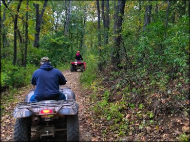
Photo Submitted 10/14/2014 (Thanks!)
Trout Valley Trail Photo
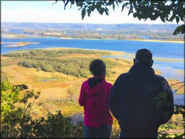
Photo Submitted 10/14/2014 (Thanks!)
Trout Valley Trail Photo
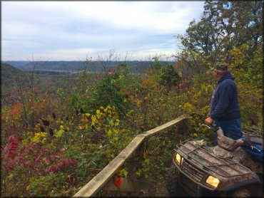
Photo Submitted 10/14/2014 (Thanks!)
ADD PHOTOS
TERRAIN
| Approx Size | 2,560 acres (4 sq mi) | |
| Miles Of Trail | 9 | |
| Climate Type | Forest | |
| Elevation | 750 to 1000 ft. | |
| Trail Maintenance | Marked, Not Rated, Lightly Maintained | |
| Loose Dirt |  Little Little | |
| Hard Pack |  Mostly Mostly | |
| Sand |  None None | |
| Mud | Little | |
| Dust | Little | |
| Rocks | Little | |
| Trees |  All All | |
| Steep Hills |  Few Few | |
| Water Crossings | Few | |
| Small Jumps | None | |
| Large Jumps | None | |
| Berms | None | |
| Sand/Gravel Pits | None | |
| Single Track | None | |
| Shade |  Many Many | |
| Hazards | Few | (hazards assumed marked but use caution) |
 Novice Novice |  Some Some | |
 Amateur Amateur | Mostly | |
 Expert Expert | Little |


KEY SERVICES
 Gasoline Gasoline | 5-20 Miles (N) | Kwik Trip (507) 767-4768 |
| Diesel | 5-20 Miles (N) | Kwik Trip (507) 767-4768 |
 Water Water | 5-20 Miles (SE) | Prairie Island Campground (507) 452-4501 |
 RV Hookup RV Hookup | 5-20 Miles (SE) | Prairie Island Campground (507) 452-4501 |
 RV Disposal RV Disposal | 5-20 Miles (SE) | Prairie Island Campground (507) 452-4501 |
| Campground | On Site | |
 Conv Store Conv Store | 5-20 Miles (N) | Kwik Trip (507) 767-4768 |
RIDER COMMENTS & REVIEWS