 |
      |
| Home > Minnesota > Solana State Forest |
Solana State Forest
Thursday, May 14, 2026
| Other Names | Snake River, Split Rock Lake, Split Rock River, Soo Line ATV Trail, White Pine Forest Road, Porcupine Lake |
| Last Known Status | Open |
The Solana State Forest offers about 15 miles of woods trails that wind over rolling hills and swampy sections. There are two staging areas however the one located in the town of McGrath offers direct access to the Soo Line Trail, which is only open to ATV use. The area is prone to temporary closures after heavy rainfalls, so be sure to call before you haul.
REGULATIONS
| Permit Required | Yes | MN OHV Permit |
| Dates Open | May 15 - October 31 | |
| Other ATV Stickers Accepted | Unknown | |
| Spark Arrestor | Yes | A spark arresting exhaust silencer or end cap is required for all vehicles. |
| Noise Limit | Yes (96 dB) | OHMs not to exceed distance of 20 inches, ATVs 99dB at 20 inches |
| Whip Flags | Not Required | |
| Maximum Vehicle Width | Yes (65 inches) | has entrance gate or posts |
 Motorcycles & Dirt Bikes Motorcycles & Dirt Bikes | Some Areas | not permitted on Soo Line ATV Trail |
 ATVs ATVs | Permitted | |
 UTV & SXS UTV & SXS | Permitted | (maximum width 65 inches) |
 SUVs & Jeeps (registered) SUVs & Jeeps (registered) | Some Areas | not permitted on Soo Line ATV Trail |
| Dune Buggy & Sand Rail 4x4 (unregistered) | Some Areas | (maximum width 65 inches) not permitted on Soo Line ATV Trail |
| 2 Stroke Engines | No Restriction | |
| MX Helmet Required | Youth Only | required for operators under 18 by state law (RiderPlanet strongly recommends helmets for all riders.) |
 Camping Camping | No Restriction | (camp anywhere) |
 Campfires Campfires | ||
| Night Riding | Unknown | |
| Trail Blazing | Prohibited | no trailblazing |
| Rule Enforcement |
Advertisement
TYPE OF AREA
| Area | Motorized Trails |
| Land | State Forest |
FEES & PASSES
| Parking | (None) |
| Entry | (None) |
| Riding | (None) |
| Camping | (None) |
RATINGS
| Our Rating |  Good Good |
| Recommended Stay | Full Day |
| Comments | (Scroll Down For Rider Reviews & Comments) |
DRIVING DIRECTIONS
| Nearest City | Mcgrath, MN | ||
| From: St. Paul, MN
1) Take I-35 North to Exit 195 2) Turn left (west) off the exit ramp on SR-18/SR-23, continue .5 miles 3) Turn right (north) at T-intersection on SR-18, continue 1.5 miles 4) Turn left (west) to stay on SR-18, continue 20 miles 5) Turn right (north) on SR-27/65, continue 2.5 miles 6) ATV staging area is on the left (west) or continue 7.5 miles to the motorcycle/OHV staging area. |


OFFICIAL CONTACTS
| Contact Info | Solana State Forest - Grand Rapids Area Office 1201 East Highway 2 Grand Rapids, MN 55744 (218) 999-7920 (218) 327-4430 info.dnr@state.mn.us www.dnr.state.mn.us |
| Contact Info | Minnesota DNR License Bureau 500 Lafayette Road St. Paul, MN 55155 (888) 665-4236 aohfmnwebmaster@activenetwork.com www.dnr.state.mn.us |
| Comment | OHV Permit Info |
Solana State Forest Trail Photo
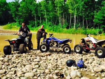
Photo Submitted 7/13/2015 (Thanks!)
Solana State Forest Trail Photo
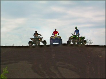
Photo Submitted 5/30/2013 (Thanks!)
Solana State Forest Trail Photo
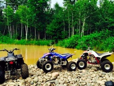
Photo Submitted 7/13/2015 (Thanks!)
ADD PHOTOS
TERRAIN
| Approx Size | 68,141 acres (106 sq mi) | |
| Miles Of Trail | 15 | |
| Climate Type | Forest | |
| Elevation | 1200 to 1300 ft. | |
| Trail Maintenance | Marked, Not Rated, Lightly Maintained | |
| Loose Dirt |  Little Little | |
| Hard Pack |  Mostly Mostly | |
| Sand | Little | |
| Mud | Little | |
| Dust | Little | |
| Rocks | Little | |
| Trees |  Many Many | |
| Steep Hills |  Few Few | |
| Water Crossings | Few | |
| Small Jumps |  None None | |
| Large Jumps | None | |
| Berms | Few | |
| Sand/Gravel Pits | None | |
| Single Track | None | |
| Roads | Few | |
| Shade |  All All | |
| Hazards | Few | (hazards assumed marked but use caution) |
 Novice Novice | Mostly | |
 Amateur Amateur | Little | |
 Expert Expert | None |
GPS POINTS


KEY SERVICES
 Gasoline Gasoline | 1-5 Miles (S) | Vie's Mobil (320) 592-3275 |
| Diesel | 1-5 Miles (S) | Vie's Mobil (320) 592-3275 |
 Water Water | 5-20 Miles (S) | Snake River Campground (218) 927-7364 |
 RV Hookup RV Hookup | 5-20 Miles (SW) | South Isle Family Campground (320) 676-8538 |
 RV Disposal RV Disposal | 5-20 Miles (SW) | Father Hennepin State Park **Open May-Mid October** (320) 676-8763 |
| Campground | 5-20 Miles (S) | Snake River Campground (218) 927-7364 |
 Conv Store Conv Store | 5-20 Miles (SW) | Teal's Market (320) 676-3376 |
RIDER COMMENTS & REVIEWS