 |
      |
| Home > Mississippi > Bethel ATV Trail |
Bethel ATV Trail
Thursday, August 21, 2025
| Other Names | Desoto National Forest, Red Creek Wildlife Management Area, Hurricane Bay, Tuxachanie Creek, Cypress Branch, Camp Branch |
| Last Known Status | Open |
This area has about 43 miles of narrow and smooth ATV trails. The terrain is mostly flat, hard packed and smooth and winds through tall grass and a mixed pine tree forest. There are no challenging sections but this is a good place to take the family or beginner rider.
The staging area offers some basic amenities that include a self pay station, picnic tables, and a vault toilet. Primitive camping is permitted and there are plenty of flat and shaded sites to choose from.
The trails are open year-round but may close temporarily on short notice due to wet weather conditions, so check the hotline before heading out. Riding is discouraged during hunting season which is between the months of October through January.
REGULATIONS
| Permit Required | No | |
| Dates Open | Year-Round | |
| Other ATV Stickers Accepted | Unknown | |
| Spark Arrestor | Yes | A spark arresting exhaust silencer or end cap is required for all vehicles. |
| Noise Limit | Yes (96 dB) | |
| Whip Flags | Not Required | |
| Maximum Vehicle Width | Yes (50 inches) | |
 Motorcycles & Dirt Bikes Motorcycles & Dirt Bikes | Permitted | |
 Four Wheelers Four Wheelers | Permitted | (maximum width 50 inches) |
 UTV & SXS UTV & SXS | Prohibited | |
 SUVs & Jeeps (registered) SUVs & Jeeps (registered) | Prohibited | |
| Dune Buggy & Sand Rail 4x4 (unregistered) | Prohibited | |
| 2 Stroke Engines | No Restriction | |
| MX Helmet Required | Yes | |
 Camping Camping | Some Areas | (camp in developed sites only) |
 Campfires Campfires | ||
| Night Riding | No | riding permitted sunrise to sunset |
| Trail Blazing | Prohibited | stay on designated trails |
| Rule Enforcement |
TYPE OF AREA
| Area | Motorized Trails |
| Land | National Forest |
FEES & PASSES
| Parking | (None) |
| Entry | (None) |
| Riding | Yes ($10.00 per rider) onsite pay station, bring exact change |
| Camping | (None) |
RATINGS
| Our Rating |  Good Good |
| Recommended Stay | Full Day |
| Comments | (Scroll Down For Rider Reviews & Comments) |
DRIVING DIRECTIONS
| Nearest City | Saucier, MS | ||
| Address | Marvin Williams Road, Saucier, MS 39574 | ||
| From: Gulfport, MS
1) Take US-49 North about 20 miles 2) Turn right (east) on SR-67, continue about 11 miles 3) Turn left (north) on Marvin Williams Road, continue about 2 miles 4) Trailhead entrance is on the right (east). |


OFFICIAL CONTACTS
| Contact Info | Desoto National Forest - De Soto Ranger District (601) 528-6180 |
| Comment | Trail Hotline |
| Contact Info | Desoto National Forest - De Soto Ranger District P.O. Box 248 Wiggins, MS 39577 (601) 528-6160 mailroom_r8_mississippi@fs.fed.us www.fs.usda.gov |
Bethel ATV Trail Photo
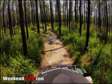
Photo Submitted 8/14/2014 (Thanks!)
Bethel ATV Trail Photo
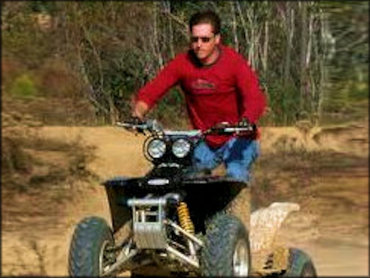
Photo Submitted 2/2/2021 (Thanks!)
Bethel ATV Trail Photo
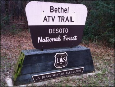
Photo Submitted 8/14/2014 (Thanks!)
ADD PHOTOS
TERRAIN
| Miles Of Trail | 43 | |
| Climate Type | Forest | |
| Elevation | 100 to 125 ft. | |
| Trail Maintenance | Marked, Not Rated, Lightly Maintained | |
| Loose Dirt |  Little Little | |
| Hard Pack |  Some Some | |
| Sand |  Mostly Mostly | |
| Mud | Little | |
| Dust | Little | |
| Rocks | Little | |
| Trees |  Many Many | |
| Steep Hills |  None None | |
| Water Crossings | None | |
| Small Jumps | None | |
| Large Jumps | None | |
| Berms | Some | |
| Sand/Gravel Pits | None | |
| Single Track | Some | |
| Roads | None | |
| Intersections |  Few Few | |
| Rider Traffic | Few | |
| Hazards | Few | (hazards assumed marked but use caution) |
 Novice Novice | Mostly | |
 Amateur Amateur | Little | |
 Expert Expert | None |


KEY SERVICES
 Gasoline Gasoline | 1-5 Miles (SW) | Dave's Chevron & Pizza Cafe (228) 832-0060 |
| Diesel | 1-5 Miles (SW) | Dave's Chevron & Pizza Cafe (228) 832-0060 |
 Water Water | 5-20 Miles (SE) | LakeView RV Resort (228) 234-4915 |
 RV Hookup RV Hookup | 5-20 Miles (SE) | LakeView RV Resort (228) 234-4915 |
 RV Disposal RV Disposal | 5-20 Miles (SE) | LakeView RV Resort (228) 234-4915 |
| Campground | On Site | primitive camping permitted |
 Conv Store Conv Store | 1-5 Miles (SW) | Dave's Chevron & Pizza Cafe (228) 832-0060 |
RIDER COMMENTS & REVIEWS