 |
      |
| Home > Montana > Hungry Horse |
Hungry Horse Motocross Track
Thursday, August 21, 2025
| Other Names | Hungry Horse, Flathead National Forest, Glacier View Ranger District, South Fork Flathead River |
| Last Known Status | Open |
Open since 1980, this natural terrain motocross track has challenging elevation changes and consists of gravel and hard packed sand plus a couple miles of ATV trails that form a short loop.
There are no fees and while overnight parking is prohibited at the track there are several campgrounds at the nearby dam. Occasional race events are scheduled during the summer months and are usually hosted by the High Country Motocross Association.
The name “Hungry Horse” comes from an unfortunate event during the winter of 1900-1901 when two horses went missing for about a month and were found belly-deep in snow. Both horses were found half starved but still alive.
REGULATIONS
| Permit Required | Yes | Montana OHV Permit |
| Dates Open | daily dawn to dusk | |
| Other ATV Stickers Accepted | No | A non-resident temporary registration sticker is required. (As of March 2020, Montana no longer honors stickers from any other states.) |
| Spark Arrestor | Yes | A spark arresting exhaust silencer or end cap is required for all vehicles. |
| Noise Limit | Yes (96 dB) | |
| Whip Flags | Not Required | |
| Maximum Vehicle Width | Yes (50 inches) | has entrance gate or posts |
 Motorcycles & Dirt Bikes Motorcycles & Dirt Bikes | Permitted | |
 ATVs ATVs | Permitted | (maximum width 50 inches) |
 UTV & SXS UTV & SXS | Prohibited | |
 4x4 & Jeeps (registered) 4x4 & Jeeps (registered) | Prohibited | |
| Dune Buggy & Sand Rail 4x4 (unregistered) | Prohibited | |
| 2 Stroke Engines | No Restriction | |
| MX Helmet Required | Youth Only | required for persons under 18 by state law (RiderPlanet strongly recommends helmets for all riders.) |
 Camping Camping | Prohibited | |
 Campfires Campfires | Prohibited | |
| Night Riding | No | Day use only |
| Rule Enforcement |
TYPE OF AREA
| Area | MX Track |
| Land | National Forest |

| Features | Public |
| Max Engine Size | No Maximum |
| Min Engine Size | No Minimum |
FEES & PASSES
| Parking | (None) |
| Entry | (None) |
| Riding | (None) |
| Camping | (None) |
RATINGS
| Our Rating |  Good Good |
| Recommended Stay | Full Day |
| Comments | (Scroll Down For Rider Reviews & Comments) |
DRIVING DIRECTIONS
| Nearest City | Hungry Horse, MT | ||
| From: Columbia Falls, MT
1) Take Hwy 2 East about 6 miles 2) Look for forest service station on the right and turn south on Colorado Blvd., continue about 1.25 miles 3) Look for a gravel road on the left (will be a hard left), turn here 4) Continue about .5 miles 5) Track will be on the right. |

OFFICIAL CONTACTS
| Contact Info | Flathead NF - Hungry Horse And Glacier View Ranger Districts 10 Hungry Horse Drive Hungry Horse, MT 59919 (406) 387-3800 mailroom_r1_flathead@fs.fed.us www.fs.usda.gov |
| Contact Info | Montana Fish, Wildlife And Parks 1420 East 6th Avenue Helena, MT 59620-0701 (406) 444-2950 fwpgen@mt.gov fwp.mt.gov |
| Comment | Montana OHV Permit Info |
Hungry Horse Track Photo
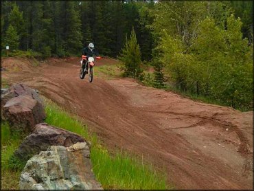
Photo Submitted 11/10/2014 (Thanks!)
Hungry Horse Track Photo
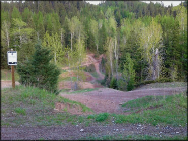
Photo Submitted 5/27/2017 (Thanks!)
Hungry Horse Track Photo
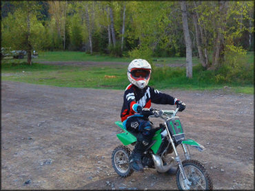
Photo Submitted 5/27/2017 (Thanks!)
ADD PHOTOS
TERRAIN
| Approx Size | 150 acres | |
| Miles Of Trail | 2 | |
| Climate Type | Urban/man-made | |
| Elevation | 3000 to 3150 ft. | |
| Loose Dirt |  Little Little | |
| Hard Pack |  Some Some | |
| Sand |  Mostly Mostly | |
| Mud | Some | |
| Dust | Little | |
| Rocks | Some | |
| Trees |  All All | |
| Steep Hills |  Few Few | |
| Water Crossings |  None None | |
| Small Jumps |  Many Many | |
| Large Jumps | Many | |
| Berms | All | |
| Sand/Gravel Pits | None | |
| Single Track | None | |
| Roads | None | |
| Shade | Some | |
| Hazards | Few | (hazards assumed marked but use caution) |
 Novice Novice | Some | |
 Amateur Amateur | Mostly | |
 Expert Expert | Some |
GPS POINTS


KEY SERVICES
 Gasoline Gasoline | 1-5 Miles (NW) | Mike's Conoco (406) 387-5271 |
| Diesel | 1-5 Miles (NW) | Mike's Conoco (406) 387-5271 |
 Water Water | 5-20 Miles (SE) | Lost Johnny Point Campground (406) 387-3800 |
 RV Hookup RV Hookup | 1-5 Miles (N) | Timber Wolf Resort (406) 387-9653 |
 RV Disposal RV Disposal | 1-5 Miles (N) | Timber Wolf Resort (406) 387-9653 |
| Campground | 5-20 Miles (SE) | Doris Creek Campground (406) 387-3800 |
 Conv Store Conv Store | 1-5 Miles (NW) | Mike's Conoco (406) 387-5271 |
RIDER COMMENTS & REVIEWS