 |
      |
| Home > Montana > Ashley Lake |
Ashley Lake OHV Trail System
Sunday, May 31, 2026
| Other Names | Flathead National Forest, Tally Lake Ranger District, Plum Creek Lumber, Stoltz Land And Lumber, Ashley Peak, Lupine Lake Trail, Ashley Mountain Trail, Ashley Divide Trail |
| Last Known Status | Open |
This area offers around 25 miles of multiple-use trails with seven miles set aside for ATVs. Most of the trails smooth and fast but narrow. The area offers excellent mountain and lake views.
There are two trailheads to access the trail system but due to limited parking large trailers are not recommended. Camping and boating can be found at nearby Ashley Lake.
The trails are seasonal and generally open around mid June through late summer but temporarily close during hunting season.
REGULATIONS
| Permit Required | Yes | Montana OHV Permit |
| Dates Open | June 1 - October 31 | |
| Other ATV Stickers Accepted | No | A non-resident temporary registration sticker is required. (As of March 2020, Montana no longer honors stickers from any other states.) |
| Spark Arrestor | Yes | A spark arresting exhaust silencer or end cap is required for all vehicles. |
| Noise Limit | Yes (96 dB) | |
| Whip Flags | Not Required | |
| Maximum Vehicle Width | Yes (50 inches) | |
 Motorcycles & Dirt Bikes Motorcycles & Dirt Bikes | Permitted | |
 ATVs ATVs | Permitted | (maximum width 50 inches) |
 UTV & SXS UTV & SXS | Permitted | (maximum width 50 inches) |
 4x4 & Jeeps (registered) 4x4 & Jeeps (registered) | Prohibited | |
| Dune Buggy & Sand Rail 4x4 (unregistered) | Prohibited | |
| 2 Stroke Engines | No Restriction | |
| MX Helmet Required | Youth Only | required for persons under 18 by state law (RiderPlanet strongly recommends helmets for all riders.) |
 Camping Camping | Some Areas | (camp in developed sites only) |
 Campfires Campfires | ||
| Night Riding | Unknown | |
| Trail Blazing | Prohibited | stay on the trail |
| Rule Enforcement |
TERRAIN
| Miles Of Trail | 25 | |
| Climate Type | Forest | |
| Elevation | 4500 to 6000 ft. | |
| Trail Maintenance | Marked, Not Rated, Lightly Maintained | |
| Loose Dirt |  Little Little | |
| Hard Pack |  Mostly Mostly | |
| Sand |  None None | |
| Mud | Little | |
| Dust | Little | |
| Rocks | Little | |
| Trees |  All All | |
| Steep Hills |  Some Some | |
| Water Crossings |  Few Few | |
| Small Jumps | None | |
| Large Jumps | None | |
| Berms |  Many Many | |
| Sand/Gravel Pits | None | |
| Single Track | None | |
| Hazards | Few | (hazards assumed marked but use caution) |
 Novice Novice | Some | |
 Amateur Amateur | Mostly | |
 Expert Expert | Little |
TYPE OF AREA
| Area | Motorized Trails |
| Land | National Forest |
GPS POINTS


KEY SERVICES
 Gasoline Gasoline | 5-20 Miles (SE) | Kelly Raes Gas Station (406) 752-5880 |
| Diesel | 5-20 Miles (SE) | Kelly Raes Gas Station (406) 752-5880 |
 Water Water | 1-5 Miles (SE) | Ashley Lake North Campground (406) 758-5200 |
 RV Hookup RV Hookup | 5-20 Miles (E) | Spruce Park on the River (406) 752-6321 or (888) 752-6321 |
 RV Disposal RV Disposal | 5-20 Miles (E) | Spruce Park on the River (406) 752-6321 or (888) 752-6321 |
| Campground | 1-5 Miles (SE) | Ashley Lake North Campground (406) 758-5200 |
 Conv Store Conv Store | 5-20 Miles (SE) | Kelly Raes Gas Station (406) 752-5880 |
FEES & PASSES
| Parking | (None) |
| Entry | (None) |
| Riding | (None) |
| Camping | (None) |
RATINGS
| Our Rating |  Good Good |
| Recommended Stay | Full Day |
| Comments | (Scroll Down For Rider Reviews & Comments) |
DRIVING DIRECTIONS
| Nearest City | Kalispell, MT | ||
| From: Kalispell, MT
1) Take US-2 West about 5 miles 2) Turn right onto Ashley Lake Road, contine about 15 miles 3) Turn right (north) on FS Road #10236, continue about 4 miles 4) Staging area is on the left (west). |

OFFICIAL CONTACTS
| Contact Info | Flathead National Forest - Tally Lake Ranger Station 650 Wolf Pack Way Kalispell, MT 59901 (406) 758-5200 mailroom_r1_flathead@fs.fed.us www.fs.usda.gov |
| Contact Info | Montana Fish, Wildlife And Parks 1420 East 6th Avenue Helena, MT 59620-0701 (406) 444-2950 fwpgen@mt.gov fwp.mt.gov |
| Comment | Montana OHV Permit Info |
Ashley Lake Trail Photo
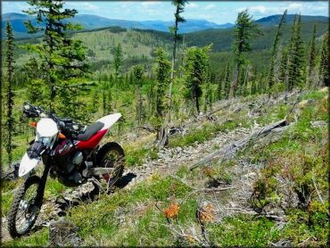
Dual sport motorcycle on the trail above the lake. Photo Submitted 11/10/2014 (Thanks!)
Ashley Lake Trail Photo
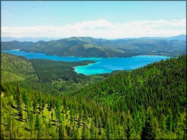
A nice view of the lake. Photo Submitted 11/10/2014 (Thanks!)
Ashley Lake Trail Photo
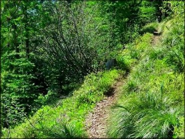
This is part of the Ashley Lake single track trail. Photo Submitted 11/10/2014 (Thanks!)
Ashley Lake Trail Photo
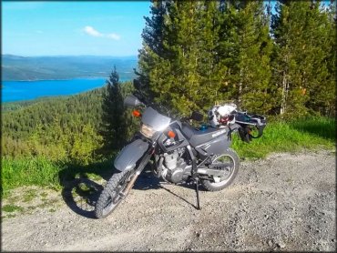
Photo Submitted 6/8/2014 (Thanks!)
RIDER COMMENTS & REVIEWS