 |
      |
| Home > Montana > Highwood Mountains |
Highwood Mountains Motorcycle Trails
Thursday, August 21, 2025
| Other Names | Thain Creek Campground, Windy Mountain, Middle Fork, Prospect Peak, Lewis And Clark National Forest |
| Last Known Status | Open |
This part of the Lewis and Clark National Forest offers about 20 miles of designated single track trails that form multiple loops. The trails are mostly smooth and twisty and wind through a nice mix of grassy meadows to deep woods with plenty of nice mountain views.
Camping with direct trail access can be found at Thain Creek Campground, which offers 12 primitive sites. There are no services except for two vault toilets, so bring your own supplies. An additional day use staging area can be found about 1/4 mile east past the entrance for the campground.
REGULATIONS
| Permit Required | Yes | Montana OHV Permit |
| Dates Open | December 2 - October 14 | |
| Other ATV Stickers Accepted | No | A non-resident temporary registration sticker is required. (As of March 2020, Montana no longer honors stickers from any other states.) |
| Spark Arrestor | Yes | A spark arresting exhaust silencer or end cap is required for all vehicles. |
| Noise Limit | Yes (96 dB) | |
| Whip Flags | Not Required | |
| Maximum Vehicle Width | ||
 Motorcycles & Dirt Bikes Motorcycles & Dirt Bikes | Permitted | |
 ATVs ATVs | Prohibited | |
 UTV & SXS UTV & SXS | Prohibited | |
 4x4 & Jeeps (registered) 4x4 & Jeeps (registered) | Prohibited | |
| Dune Buggy & Sand Rail 4x4 (unregistered) | Prohibited | |
| 2 Stroke Engines | No Restriction | |
 Camping Camping | Some Areas | (camp in developed sites only) |
 Campfires Campfires | Some Areas | (permitted in developed campsites only) |
| Night Riding | Unknown | |
| Trail Blazing | Prohibited | stay on trail |
| Rule Enforcement |
TYPE OF AREA
| Area | Motorized Trails |
| Land | National Forest |
FEES & PASSES
| Parking | (None) |
| Entry | (None) |
| Riding | (None) |
| Camping | Yes Tent: $5.00 RV: $5.00 Addtl. Vehicle: $0.00 Thain Creek Campground Fee |
RATINGS
| Our Rating |  Good Good |
| Recommended Stay | Full Day |
| Comments | (Scroll Down For Rider Reviews & Comments) |
DRIVING DIRECTIONS
| Nearest City | Highwood, MT | ||
| Address | Thain Creek Road, Highwood, MT 59450 | ||
| From: Great Falls, MT
1) Take US-87 East about 5 miles 2) Turn left (north) onto Highwood Road, continue 13.7 miles 3) Turn left to stay on Highwood Road, continue about 6 miles 4) Turn right (east) onto Upper Highwood Creek Road, continue 13.6 miles 5) Campground entrance is on the left. |


OFFICIAL CONTACTS
| Contact Info | Lewis And Clark National Forest 1101 15th ST No. Great Falls, MT 59401 (406) 791-7700 mailroom_r1_lewis_and_clark@fs.fed.us www.fs.usda.gov |
| Contact Info | Montana Fish, Wildlife And Parks 1420 East 6th Avenue Helena, MT 59620-0701 (406) 444-2950 fwpgen@mt.gov fwp.mt.gov |
| Comment | Montana OHV Permit Info |
Highwood Mountains Trail Photo
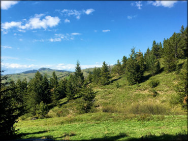
Photo Submitted 5/22/2017 (Thanks!)
Highwood Mountains Trail Photo
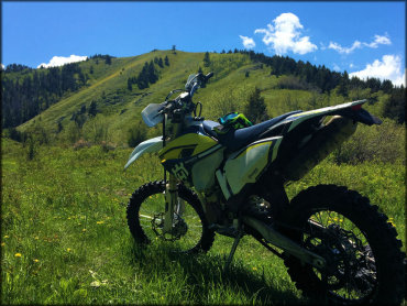
Photo Submitted 5/22/2017 (Thanks!)
ADD PHOTOS
TERRAIN
| Approx Size | 12,800 acres (20 sq mi) | |
| Miles Of Trail | 20 | |
| Climate Type | Forest | |
| Elevation | 4500 to 5500 ft. | |
| Trail Maintenance | Marked, Not Rated, Lightly Maintained | |
| Loose Dirt |  Little Little | |
| Hard Pack |  Mostly Mostly | |
| Sand |  None None | |
| Mud | Little | |
| Dust | Little | |
| Rocks | Little | |
| Trees |  All All | |
| Steep Hills |  Some Some | |
| Water Crossings |  Few Few | |
| Small Jumps | None | |
| Large Jumps | None | |
| Berms |  Many Many | |
| Sand/Gravel Pits | None | |
| Single Track | All | |
| Roads | None | |
| Intersections | Some | |
| Rider Traffic | Few | |
| Shade | Many | |
| Hazards | Few | (hazards assumed marked but use caution) |
 Novice Novice | Little | |
 Amateur Amateur | Mostly | |
 Expert Expert | Some |
GPS POINTS


KEY SERVICES
 Gasoline Gasoline | 5-20 Miles (NW) | Highwood Service Station (406) 733-5251 |
| Diesel | 30+ Miles (W) | Sinclair (406) 727-5746 |
 Water Water | 30+ Miles (SW) | Fort Ponderosa Campground (406) 277-3232 |
 RV Hookup RV Hookup | 30+ Miles (SW) | Fort Ponderosa Campground (406) 277-3232 |
 RV Disposal RV Disposal | 30+ Miles (SW) | Fort Ponderosa Campground (406) 277-3232 |
| Campground | On Site | Thain Creek Campground (406) 566-2292 |
 Conv Store Conv Store | 30+ Miles (W) | Sinclair (406) 727-5746 |
RIDER COMMENTS & REVIEWS