 |
      |
| Home > Montana > Darby Trails |
Darby Trails
Thursday, August 21, 2025
| Other Names | Bitterroot National Forest, Darby Ranger District, Saphire Mountains, Bitterroot Valley, Rye Creek, Sleeping Child Creek, Ravalli County |
| Last Known Status | Open |
At one time this land was privately owned by a lumbar company but was recently acquired by the Bitterroot National Forest. With help from Ravalli County Off Road User Association, two long loops were designated for motorized use. Both loops are marked with brown carsonite posts that are labled with directional arrows and vehicle type.
A small staging area is located near the end of Sleeping Child Road but caution is advised for those with trailers/RVs as there is currently no developed parking areas.
Be sure to thank the Ravalli County Off Road User Association and the Bitterroot National Forest for these awesome new trails.
REGULATIONS
| Permit Required | Yes | Montana OHV Permit |
| Dates Open | Year-Round | |
| Other ATV Stickers Accepted | No | A non-resident temporary registration sticker is required. (As of March 2020, Montana no longer honors stickers from any other states.) |
| Spark Arrestor | Yes | A spark arresting exhaust silencer or end cap is required for all vehicles. |
| Noise Limit | Yes (96 dB) | |
| Whip Flags | Not Required | |
| Maximum Vehicle Width | Yes (50 inches) | has entrance gate or posts |
 Motorcycles & Dirt Bikes Motorcycles & Dirt Bikes | Permitted | |
 ATVs ATVs | Permitted | (maximum width 50 inches) |
 UTV & SXS UTV & SXS | Permitted | (maximum width 50 inches) |
 4x4 & Jeeps (registered) 4x4 & Jeeps (registered) | Prohibited | |
| Dune Buggy & Sand Rail 4x4 (unregistered) | Prohibited | |
| 2 Stroke Engines | No Restriction | |
 Camping Camping | ||
 Campfires Campfires | ||
| Night Riding | Unknown | Not Recommended |
| Trail Blazing | Prohibited | no trailblazing |
| Rule Enforcement |
TYPE OF AREA
| Area | Motorized Trails |
| Land | National Forest |
FEES & PASSES
| Parking | (None) |
| Entry | (None) |
| Riding | (None) |
| Camping | (None) |
RATINGS
| Our Rating |  Good Good |
| Recommended Stay | Full Day |
| Comments | (Scroll Down For Rider Reviews & Comments) |
DRIVING DIRECTIONS
| Nearest City | Darby, MT | ||
| Address | Rye Creek Road, Darby, MT 59829 | ||
| From: Missoula, MT
For Sleeping Child Staging Area: 1) Take Hwy 93 South about 40 miles 2) Turn left (south-east) onto Hwy 38, continue .7 miles 3) Turn right (east) onto Sleeping Child Road, continue about 11 miles 4) Staging area is on the right. *Note: After parking take FS Road 273/White Stallion Road west about 12 miles to Loop 1. For North Fork Road Staging Area: 5) Continue south on Hwy 93 about 18 miles 6) Turn left (east) onto Rye Creek Road, continue 5.5 miles 7) Turn left (north) onto North Fork Road, continue 5.3 miles. For Rye Creek Staging Area: 8) Continue east on Rye Creek Road 2.8 miles 9) Staging area is on the left. *Note: After parking continue north on Rye Creek Road for about 1 mile to access Loop 2. |

OFFICIAL CONTACTS
| Contact Info | Bitterroot National Forest - Darby Ranger District P.O. Box 388 Darby, MT 59829 (406) 821-3913 mailroom_r1_bitterroot@fs.fed.us www.fs.usda.gov |
| Contact Info | Ravalli County Off Road User Association P.O. Box 72 Hamilton, MT 59840 bitterrootvalleychamber.chambermaster.com |
Darby Trails Photo
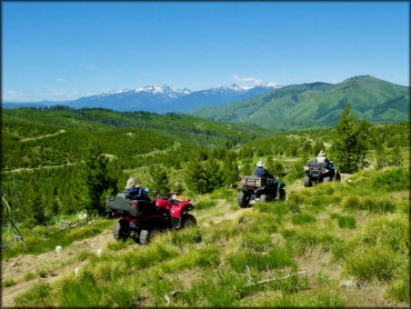
Photo Submitted 3/16/2019 (Thanks!)
Darby Trails Photo
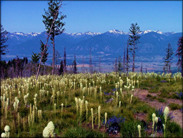
Photo Submitted 3/16/2019 (Thanks!)
ADD PHOTOS
TERRAIN
| Approx Size | 28,800 acres (45 sq mi) | |
| Miles Of Trail | 44 | |
| Climate Type | Forest | |
| Elevation | 5200 to 7000 ft. | |
| Trail Maintenance | Marked, Not Rated, Lightly Maintained | |
| Loose Dirt |  Little Little | |
| Hard Pack |  Mostly Mostly | |
| Sand |  None None | |
| Mud |  Some Some | |
| Dust | Little | |
| Rocks | Some | |
| Trees |  All All | |
| Steep Hills |  Few Few | |
| Water Crossings | None | |
| Small Jumps | None | |
| Large Jumps | None | |
| Berms | Few | |
| Sand/Gravel Pits | None | |
| Single Track | Few | |
| Roads | Some | |
| Shade | All | |
| Hazards | Few | (hazards assumed marked but use caution) |
 Novice Novice | Mostly | |
 Amateur Amateur | Some | |
 Expert Expert | None |
GPS POINTS


KEY SERVICES
 Gasoline Gasoline | 5-20 Miles (NW) | Cenex (406) 821-1940 |
| Diesel | 5-20 Miles (NW) | Cenex (406) 821-1940 |
 Water Water | Darby, MT | |
 RV Hookup RV Hookup | 5-20 Miles (W) | Travellers Rest Cabins and RV Park (406) 821-3282 |
 RV Disposal RV Disposal | 5-20 Miles (W) | Travellers Rest Cabins and RV Park (406) 821-3282 |
| Campground | 5-20 Miles (W) | Hannon Memorial Fishing Access Site and Campground (406) 542-5561 or (406) 375-2611 |
 Conv Store Conv Store | 5-20 Miles (NW) | Cenex (406) 821-1940 |
RIDER COMMENTS & REVIEWS