 |
      |
| Home > Montana > Woodchopper Ridge |
Woodchopper Ridge
Thursday, August 21, 2025
| Other Names | Lewis And Clark National Forest, Belt Creek Ranger District, Little Belt Mountains, Rocky Mountains, Kelly Mountain, Middle Fork Judith River, Yogo Peak, Yogo Creek, Coyote Peak, Big Deer Point |
| Last Known Status | Open |
This area offers a scenic but rugged linear ATV trail and a handful of single track trails. The main trail is about 11 miles long and starts off near Yogo Creek and heads west, gradually climbing Woodchopper Ridge, Kelly Mountain and eventually ending near Yogo Peak. There are some single track trails that branch off the main trail that form several side loops, eventually tying into the surrounding forest service roads.
This trail system is close to the Russian Flat Area but there appears to be no direct access from Woodchopper Ridge, so you will have to haul unless street legal. This area has a short season and is generally snow free and open to motorized use between July through the end of August. For current conditions contact the Belt Creek Ranger District before heading out.
A small campground with three sites can be found at Judith Guard Station. A cabin rental is also available which can comfortably sleep up to eight people. Amenities include basic cooking utensils, kitchen table with chairs, outdoor porch, propane heating and cookstove, drinking water (summer months only) and gas lanterns (bring your own propane cylinders). Additional camping can be found at Indian Hill, Hay Canyon, Dry Pole Canyon and Russian Flat.
REGULATIONS
| Permit Required | Yes | Montana OHV Permit |
| Dates Open | July 1 - August 31 | |
| Other ATV Stickers Accepted | No | A non-resident temporary registration sticker is required. (As of March 2020, Montana no longer honors stickers from any other states.) |
| Spark Arrestor | Yes | A spark arresting exhaust silencer or end cap is required for all vehicles. |
| Noise Limit | Yes (96 dB) | |
| Whip Flags | Not Required | |
| Maximum Vehicle Width | Yes (50 inches) | has entrance gate or posts |
 Motorcycles & Dirt Bikes Motorcycles & Dirt Bikes | Permitted | |
 ATVs ATVs | Permitted | (maximum width 50 inches) |
 UTV & SXS UTV & SXS | Permitted | (maximum width 50 inches) |
 4x4 & Jeeps (registered) 4x4 & Jeeps (registered) | Prohibited | |
| Dune Buggy & Sand Rail 4x4 (unregistered) | Prohibited | |
| 2 Stroke Engines | No Restriction | |
| MX Helmet Required | Youth Only | required for persons under 18 by state law (RiderPlanet strongly recommends helmets for all riders.) |
 Camping Camping | Some Areas | (camp in developed sites only) |
 Campfires Campfires | Some Areas | (permitted in developed campsites only) |
| Night Riding | Unknown | Not Recommended |
| Trail Blazing | Prohibited | stay on trails |
| Rule Enforcement |
TYPE OF AREA
| Area | Motorized Trails |
| Land | National Forest |
FEES & PASSES
| Parking | (None) |
| Entry | (None) |
| Riding | (None) |
| Camping | (None) |
| Comment | Cabin rental fee - $60/night. |
RATINGS
| Our Rating |  Good Good |
| Recommended Stay | Full Day |
| Comments | (Scroll Down For Rider Reviews & Comments) |
DRIVING DIRECTIONS
| Nearest City | Sapphire Village, MT | ||
| From: Great Falls, MT
1) Take US-87 South about 65 miles 2) Turn right (south) onto MT-541, continue about 11 miles 3) Turn right (south) onto Utica Loop/Pigeye Road, continue about 13 miles 4) Turn right (north) onto S Fork Road/Yoga Creek Road, continue about 2 miles toward trailhead. |


OFFICIAL CONTACTS
| Contact Info | Lewis And Clark National Forest - Belt Creek Ranger District 4234 US Highway 89 North Neihart, MT 59465 (406) 236-5100 mailroom_r1_lewis_and_clark@fs.fed.us www.fs.usda.gov |
| Contact Info | Montana Fish, Wildlife And Parks 1420 East 6th Avenue Helena, MT 59620-0701 (406) 444-2950 fwpgen@mt.gov fwp.mt.gov |
| Comment | Montana OHV Permit Info |
Woodchopper Ridge Trail Photo
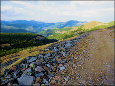
Photo Submitted 1/31/2019 (Thanks!)
ADD PHOTOS
TERRAIN
| Approx Size | 16,000 acres (25 sq mi) | |
| Miles Of Trail | 20 | |
| Climate Type | Forest | |
| Elevation | 6150 to 8100 ft. | |
| Trail Maintenance | Marked, Not Rated, Lightly Maintained | |
| Loose Dirt |  None None | |
| Hard Pack |  Mostly Mostly | |
| Sand | None | |
| Mud |  Little Little | |
| Dust |  Some Some | |
| Rocks | Some | |
| Trees |  All All | |
| Steep Hills | Some | |
| Water Crossings |  Few Few | |
| Small Jumps | None | |
| Large Jumps | None | |
| Berms | Few | |
| Sand/Gravel Pits | None | |
| Single Track | Some | |
| Roads | Few | |
| Intersections | Some | |
| Rider Traffic | Few | |
| Shade |  Many Many | |
| Hazards | Few | (hazards assumed marked but use caution) |
 Novice Novice | Little | |
 Amateur Amateur | Mostly | |
 Expert Expert | Some |
GPS POINTS


KEY SERVICES
 Gasoline Gasoline | 20-30 Miles (NE) | Eddies Corner (406) 374-2471 |
| Diesel | 20-30 Miles (NE) | Eddies Corner (406) 374-2471 |
 Water Water | On Site | Judith Guard Station (406) 236-5100 |
 RV Hookup RV Hookup | 30+ Miles (NW) | Fort Ponderosa Campground (406) 277-3232 |
 RV Disposal RV Disposal | 30+ Miles (NW) | Fort Ponderosa Campground (406) 277-3232 |
| Campground | On Site | Judith Guard Station (406) 236-5100 |
 Conv Store Conv Store | 20-30 Miles (NE) | Eddies Corner (406) 374-2471 |
RIDER COMMENTS & REVIEWS