 |
      |
| Home > Montana > Pryor Mountains |
Pryor Mountains
Thursday, August 21, 2025
| Other Names | Custer Gallatin National Forest, Beartooth Ranger District |
| Last Known Status | Open |
This part of the Custer Gallatin National Forest offers miles of forest service roads and trails with varying degrees of difficulties that are open to motorized use. The trails offer numerous panoramic mountain and canyon views. Wild horses and ice caves are also among the area attractions.
Camping is available at Sage Creek Campground, which has 12 sites that can accommodate trailers up to 30 feet long. There is no direct off-road trail access from the campground so unless street legal, you will have to haul your bikes to and from the trailhead.
REGULATIONS
| Permit Required | Yes | Montana OHV Permit |
| Dates Open | Year-Round | |
| Other ATV Stickers Accepted | No | A non-resident temporary registration sticker is required. (As of March 2020, Montana no longer honors stickers from any other states.) |
| Spark Arrestor | Yes | A spark arresting exhaust silencer or end cap is required for all vehicles. |
| Noise Limit | Yes (96 dB) | |
| Whip Flags | Not Required | |
| Maximum Vehicle Width | No Restriction | |
 Motorcycles & Dirt Bikes Motorcycles & Dirt Bikes | Permitted | |
 ATVs ATVs | Permitted | |
 UTV & SXS UTV & SXS | Permitted | |
 4x4 & Jeeps (registered) 4x4 & Jeeps (registered) | Permitted | |
| Dune Buggy & Sand Rail 4x4 (unregistered) | Permitted | |
| 2 Stroke Engines | No Restriction | |
| MX Helmet Required | Youth Only | required for persons under 18 by state law (RiderPlanet strongly recommends helmets for all riders.) |
 Camping Camping | Some Areas | (camp in developed sites only) |
 Campfires Campfires | Some Areas | (permitted in developed campsites only) |
| Night Riding | Unknown | |
| Trail Blazing | Prohibited | stay on the trail |
| Rule Enforcement |
TERRAIN
| Approx Size | 19,200 acres (30 sq mi) | |
| Miles Of Trail | 20 | |
| Climate Type | Forest | |
| Elevation | 7000 to 8500 ft. | |
| Trail Maintenance | Marked, Not Rated, Lightly Maintained | |
| Loose Dirt |  Little Little | |
| Hard Pack |  Mostly Mostly | |
| Sand |  None None | |
| Mud | Little | |
| Dust |  Some Some | |
| Rocks | Mostly | |
| Trees |  Many Many | |
| Steep Hills | Some | |
| Small Jumps | None | |
| Large Jumps | None | |
| Berms | None | |
| Sand/Gravel Pits | None | |
| Single Track | None | |
| Roads | Some | |
| Shade | Many | |
| Hazards |  Few Few | (hazards assumed marked but use caution) |
 Novice Novice | Some | |
 Amateur Amateur | Mostly | |
 Expert Expert | Little |
TYPE OF AREA
| Area | Motorized Trails |
| Land | National Forest |


KEY SERVICES
 Gasoline Gasoline | 30+ Miles (NW) | Town and Country Supply Gas Station (406) 662-3623 |
| Diesel | 30+ Miles (NW) | Town and Country Supply Gas Station (406) 662-3623 |
 Water Water | 30+ Miles (W) | Red Lodge KOA (406) 446-2364 |
 RV Hookup RV Hookup | 30+ Miles (W) | Red Lodge KOA (406) 446-2364 |
 RV Disposal RV Disposal | 30+ Miles (W) | Red Lodge KOA (406) 446-2364 |
| Campground | 1-5 Miles (NW) | Sage Creek Campground (406) 446-2103 |
 Conv Store Conv Store | 30+ Miles (NW) | Town and Country Supply Gas Station (406) 662-3623 |
FEES & PASSES
| Parking | (None) |
| Entry | (None) |
| Riding | (None) |
| Camping | Yes Tent: $10.00 RV: $10.00 Addtl. Vehicle: $0.00 Sage Creek Campground Fee |
RATINGS
| Our Rating |  Good Good |
| Recommended Stay | Full Day |
| Comments | (Scroll Down For Rider Reviews & Comments) |
DRIVING DIRECTIONS
| Nearest City | Bridger, MT | ||
| Address | Pryor Mountain Road, Bridger, MT 59014 | ||
| From: Billings, MT
1) Take I-90 West to Exit 434 2) Turn left (south) onto Hwy 212/310, continue 16 miles 3) Turn left (south) onto Hwy 310, continue 20 miles 4) Turn left (east) onto Pryor Mountain Road, continue 12 miles 5) Turn left (north) to stay on Pryor Mountain Road, continue about 11 miles 6) Sage Creek campground entrance is on the left 7) For trailhead continue east past Sage Creek campground about 7 miles. |

OFFICIAL CONTACTS
| Contact Info | Custer Gallatin National Forest - Beartooth Ranger District 6811 Hwy 212 Red Lodge, MT 59068 (406) 446-2103 mailroom_r1_custer_gallatin@fs.fed.us www.fs.usda.gov |
Pryor Mountains Trail Photo
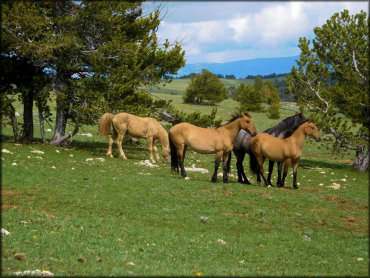
Photo Submitted 8/16/2019 (Thanks!)
Pryor Mountains Trail Photo
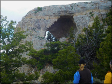
Photo Submitted 8/16/2019 (Thanks!)
Pryor Mountains Trail Photo
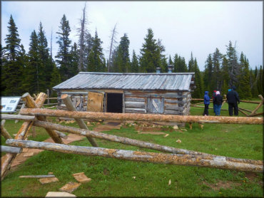
Photo Submitted 8/16/2019 (Thanks!)
Pryor Mountains Trail Photo
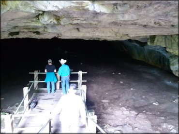
Photo Submitted 8/16/2019 (Thanks!)
Pryor Mountains Trail Photo
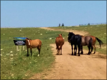
Photo Submitted 8/16/2019 (Thanks!)
RIDER COMMENTS & REVIEWS