 |
      |
| Home > Nevada > Bull Ranch Creek |
Bull Ranch Creek
Monday, September 8, 2025
| Other Names | Mogul, Dog Valley, Northgate, Verdi, Sticky Peak, Verdi Peak, North Flat, Mogul Mountain, Back Side Peavine Mountain, Toiyabe National Forest, Mitchell Canyon, Cow Canyon, Peavine Maze |
| Last Known Status | Open |
If you are coming to Reno to ride, this place is not to be overlooked. Moon Rocks may be more popular, but in our opinion Dog Valley is more fun, with some interesting scenic views of the nearby Truckee River, Cold Springs, Peavine Mountain and Reno.
What makes it so fun is the wide variety of terrain, with trails that wind through sand and desert sage, teeter along the mountain ridges, and then tunnel deep into the woods. Many of the woods trails are single track (and we mean 18 inches wide), and the rest are perfect for ATVs (recent improvements have been made to the single track trails, so be sure to say thanks to the Reno Area Dirt Riders for all their hard work).
Note that some of the wooded areas don't thaw until late May or even June. This is listed as a Nevada riding area because it is closest to Reno, but large portions are in California. You'll need either a Nevada OHV sticker or a California OHMVR sticker. Both states reciprocate.
REGULATIONS
| Permit Required | Yes | NVOHV sticker required |
| Dates Open | Year-Round | |
| Other ATV Stickers Accepted | Yes | Nevada registration is not required if the vehicle is already registered in another state and will be located in Nevada for no more than 15 days. |
| Spark Arrestor | Yes | A spark arresting exhaust silencer or end cap is required for all vehicles. (staging area and large portion of trails are in California) |
| Noise Limit | Yes (96 dB) | (staging area and large portion of trails are in California) |
| Whip Flags | Not Required | |
| Maximum Vehicle Width | ||
 Motorcycles & Dirt Bikes Motorcycles & Dirt Bikes | Some Areas | |
 ATVs ATVs | Some Areas | some trails too narrow for ATVs |
 UTV & SXS UTV & SXS | Some Areas | |
 SUVs & Jeeps (registered) SUVs & Jeeps (registered) | Some Areas | |
| Dune Buggy & Sand Rail 4x4 (unregistered) | Some Areas | |
| 2 Stroke Engines | Certain Times | |
 Camping Camping | Some Areas | some primitive camping available |
 Campfires Campfires | Some Areas | |
| Night Riding | Yes | Not Recommended |
| Trail Blazing | Prohibited | stay on trail |
| Alcohol | Some Areas | |
| Rule Enforcement | Some | Jeep/SUV Patrol ATV/Saddle Mounted Patrol |
| Comment | *Sometimes officers on trail bikes will check for California OHV stickers in the National Forest area. They hang out in the forested area where the trail crosses back and forth from Nevada to California, so be sure that your bike is legal in BOTH states. | |
TERRAIN
| Approx Size | 25,600 acres (40 sq mi) | |
| Miles Of Trail | 100 | |
| Climate Type | Forest | |
| Elevation | 4850 to 8300 ft. | |
| Trail Maintenance | Not Marked, Not Rated, Lightly Maintained | |
| Loose Dirt |  Some Some | |
| Hard Pack | Some | |
| Sand |  Little Little | |
| Mud | Little | |
| Dust | Some | |
| Rocks | Little | |
| Trees |  Many Many | |
| Steep Hills | Some | |
| Water Crossings |  Few Few | |
| Small Jumps | Some | |
| Large Jumps | Few | |
| Berms | Some | |
| Sand/Gravel Pits |  None None | |
| Single Track | Many | |
| Roads | Some | |
| Intersections | Few | |
| Rider Traffic | Few | |
| Shade | Many | |
| Ranges/Gunfire | Few | |
| Hazards | Few | (hazards not marked) Beware of cliffs. |
 Novice Novice | Some | |
 Amateur Amateur |  Mostly Mostly | |
 Expert Expert | Little |
TYPE OF AREA
| Area | Motorized Trails, also has play area near staging area |
| Land | BLM, National Forest |


KEY SERVICES
 Gasoline Gasoline | 1-5 Miles (SE) | Chevron (775) 345-6000 |
| Diesel | 1-5 Miles (SE) | Chevron (775) 345-6000 |
 Water Water | 5-20 Miles (SW) | Boca Springs Campground (877) 444-6777 or (530) 587-3558 |
 RV Hookup RV Hookup | 1-5 Miles (SE) | Boomtown/KOA (877) 626-6686 |
 RV Disposal RV Disposal | 1-5 Miles (SE) | Boomtown/KOA (877) 626-6686 |
| Campground | 5-20 Miles (SW) | Boca Rest Campground (877) 444-6777 or (530) 587-3558 |
 Conv Store Conv Store | 1-5 Miles (SE) | Chevron (775) 345-6000 |
FEES & PASSES
| Parking | (None) |
| Entry | (None) |
| Riding | (None) |
| Camping | (None) |
RATINGS
| Pros | wide variety of terrain, fair amount of single track, not crowded, good scenery, easy access to staging area |
| Cons | often dry and dusty, easy to get disoriented, few trail markings or directional signs |
| Our Rating |  Very Good Very Good |
| Recommended Stay | Full Day Recommended June-November |
| Comments | (Scroll Down For Rider Reviews & Comments) |
DRIVING DIRECTIONS
| Nearest City | Reno, NV | ||
| From: Reno, NV
For Red Metal Staging Area: 1) Take US 395 North to Exit 78 2) Turn left (south) off the exit ramp onto Red Rock Road, continue under the bridge 3) Turn right (west) onto Virginia Street, continue 1.5 miles 4) Turn left (south) onto dirt road, continue about .25 miles 5) Staging area is on the right. For Peavine Access Road: 1) Take US 395 North to Exit 76 2) Turn left (south) off the exit ramp onto Stead Blvd, continue under the bridge 3) Turn right (north) onto Virginia Street, continue .8 miles 4) Turn left (south) onto Peavine Road, continue about .5 miles. For Hirschdale/Boca Reservoir (Good for RVs and large trailers) 1) Take I-80 West to Exit 194/Hirschdale 2) Turn left (west) off the exit ramp onto Hirschdale/Stampede Meadows Road, continue about 3 miles 3) Boca Rest campground will be on the left, right on the water at the mouth of the river. |


OFFICIAL CONTACTS
| Contact Info | Humboldt - Toiyabe National Forest Headquarters 1200 Franklin Way Sparks, NV 89431 (775) 331-6444 mailroom_r4_humboldt_toiyabe@fs.fed.us www.fs.usda.gov |
| Contact Info | Tahoe National Forest - Truckee Ranger District 9646 Donner Pass Road Truckee, CA 96161-2949 (530) 587-3558 mailroom_r5_tahoe@fs.fed.us www.fs.usda.gov |
| Contact Info | Reno Area Dirt Riders radmins@renoareadirtriders.com renoareadirtriders.com |
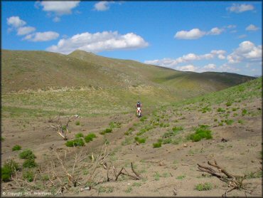
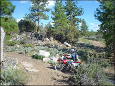
Bull Ranch Creek Trail Photo
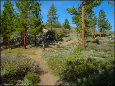
The nice thing about Dog Valley is that it has a little bit of everything...
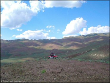
Bull Ranch Creek Trail Photo
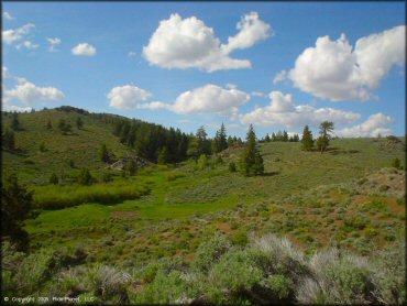
Another nice scenic shot from somewhere on the back side of Peavine.
Bull Ranch Creek Trail Photo
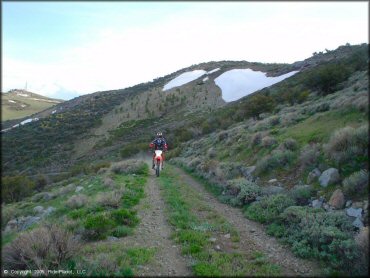
You also get to climb and there are some great scenic hilltop views from the rocky fire roads. The rocks are sharp though.
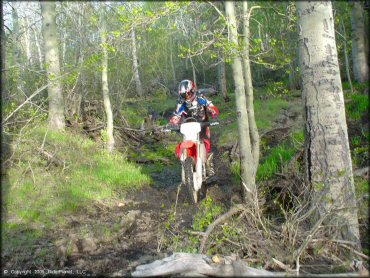
Bull Ranch Creek Trail Photo
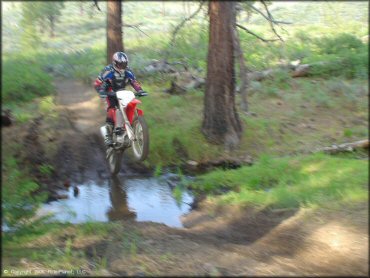
And a couple of simple stream crossings (seasonal).
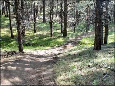
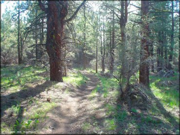
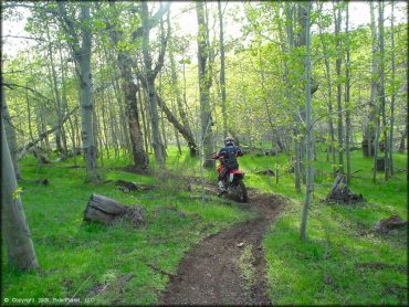
Bull Ranch Creek Trail Photo
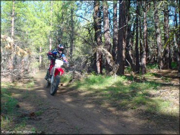
The trails are pretty smooth in the woods. Not too many rocks.
Bull Ranch Creek Trail Photo
And some great woods trails.
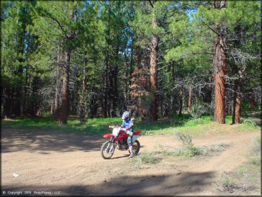
Bull Ranch Creek Trail Photo
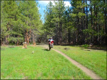
There are a bunch of single track trails that occasionally break into small clearings.
Bull Ranch Creek Trail Photo
And there is great scenery everywhere.
Bull Ranch Creek Trail Photo
There are also some vast open hills with sandy single track trails and hill climbs...
Bull Ranch Creek Trail Photo
These are some more scenic hills heading toward Red Rock Road.
Bull Ranch Creek Trail Photo
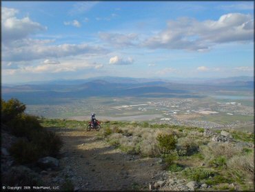
Some spectacular views of Cold Springs and Reno from the top of Peavine Mountain.
Bull Ranch Creek Trail Photo
This from the back side of Peavine near where the woods trails begin.
Bull Ranch Creek Trail Photo
One of the connecting routes.
Bull Ranch Creek Trail Photo
A GPS is handy here to keep track of where you are. There are enough connecting trails in this area between Stampede and Cold Springs and Mogul to run you right out of gas if you explore too randomly.
Bull Ranch Creek Trail Photo
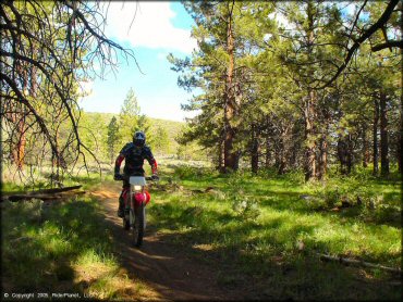
And some more woods trails.
Bull Ranch Creek Trail Photo
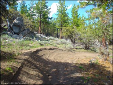
Woods trails with berms... my favorite!
Bull Ranch Creek Trail Photo
A little mud here, but really most of the area is very dry.
Bull Ranch Creek Trail Photo
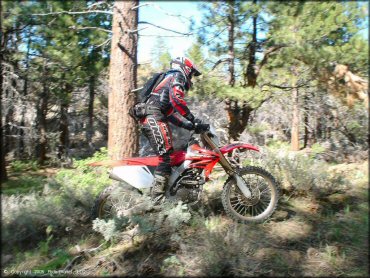
There are also some short sections of very tight woods single track, almost swampy.
RIDER COMMENTS & REVIEWS