 |
      |
| Home > New Hampshire > Arrowhead Ski Area |
Arrowhead Ski Area
Friday, May 22, 2026
| Other Names | Sullivan County ATV Club |
| Last Known Status | Open |
This area offers a 4.5 mile long trail loop that is open to ATVs and UTVs during the summer months. Most of the trail is marked and lightly graveled but there is also a good mix of moderate elevation changes, tree roots and loose chunk rock to navigate.
The trail eventually leads to the top of a rocky ledge with the American Flag and a log cabin, providing some nice views of the town of Claremont and surrounding rolling hills. The Sullivan County ATV Club is active in maintaining these trails, so be sure to say thanks for all their hard work.
This trail system closes to ATV riding during the winter months and reopens after mud season (exact opening dates may vary so call first before heading out).
REGULATIONS
| Permit Required | Yes | NH OHRV Sticker |
| Dates Open | Late May through late Fall | |
| Spark Arrestor | Yes | A spark arresting exhaust silencer or end cap is required for all vehicles. |
| Noise Limit | Yes (96 dB) | |
| Whip Flags | Not Required | |
| Maximum Vehicle Width | Yes (65 inches) | has entrance gate or posts |
 Motorcycles & Dirt Bikes Motorcycles & Dirt Bikes | ||
 ATVs ATVs | Permitted | |
 UTV & SXS UTV & SXS | Permitted | (maximum width 65 inches) |
 SUVs & Jeeps (registered) SUVs & Jeeps (registered) | Prohibited | |
| Dune Buggy & Sand Rail 4x4 (unregistered) | Prohibited | |
| 2 Stroke Engines | No Restriction | |
| MX Helmet Required | Yes | |
 Camping Camping | Prohibited | |
 Campfires Campfires | Prohibited | |
| Night Riding | No | |
| Trail Blazing | Prohibited | stay on trails |
| Rule Enforcement |
TYPE OF AREA
| Area | Motorized Trails |
| Land | Privately Owned / Commercial |
FEES & PASSES
| Parking | (None) |
| Entry | (None) |
| Riding | (None) |
| Camping | (None) |
RATINGS
| Our Rating |  Good Good |
| Recommended Stay | Full Day |
| Comments | (Scroll Down For Rider Reviews & Comments) |
DRIVING DIRECTIONS
| Nearest City | Claremont, NH | ||
| Address | 18 Robert Easter Way, Claremont, NH 03743 | ||
| From: Claremont, NH
1) Take Pleasant Street south about 1 mile 2) Turn left (east) on South Street, continue .5 miles 3) Turn right (south) onto Robert Easter Way, follow into ski parking lot, stage here. |


OFFICIAL CONTACTS
| Contact Info | Sullivan County ATV Club P.O. Box 64 Claremont, NH 03743 (603) 287-1203 sullivancountyatv@gmail.com sullivancountyatv.org |
Arrowhead Ski Area Trail Photo
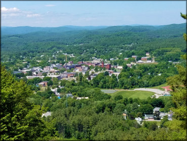
Photo Submitted 8/17/2018 (Thanks!)
ADD PHOTOS
TERRAIN
| Approx Size | 282 acres | |
| Miles Of Trail | 4 | |
| Climate Type | Forest | |
| Elevation | 575 to 1000 ft. | |
| Trail Maintenance | Marked, Not Rated, Lightly Maintained | |
| Loose Dirt |  Little Little | |
| Hard Pack |  Mostly Mostly | |
| Sand |  None None | |
| Mud |  Some Some | |
| Dust | Little | |
| Rocks | Little | |
| Trees |  All All | |
| Steep Hills | None | |
| Water Crossings | None | |
| Small Jumps | None | |
| Large Jumps | None | |
| Berms | None | |
| Sand/Gravel Pits | None | |
| Single Track | None | |
| Roads | Some | |
| Shade |  Many Many | |
| Hazards |  Few Few | (hazards assumed marked but use caution) |
 Novice Novice | Some | |
 Amateur Amateur | Mostly | |
 Expert Expert | Little |


KEY SERVICES
 Gasoline Gasoline | 1-5 Miles (N) | Cumberland Farms (603) 542-1510 |
| Diesel | 1-5 Miles (N) | Cumberland Farms (603) 542-1510 |
 Water Water | 5-20 Miles (W) | Getaway Mountain and Campground (802) 674-2812 |
 RV Hookup RV Hookup | 5-20 Miles (W) | Getaway Mountain and Campground (802) 674-2812 |
 RV Disposal RV Disposal | 5-20 Miles (W) | Getaway Mountain and Campground (802) 674-2812 |
| Campground | 5-20 Miles (W) | Getaway Mountain and Campground (802) 674-2812 |
 Conv Store Conv Store | 1-5 Miles (N) | Cumberland Farms (603) 542-1510 |
RIDER COMMENTS & REVIEWS