 |
      |
| Home > New Mexico > Benson Ridge |
Benson Ridge
Thursday, August 21, 2025
| Other Names | Lincoln National Forest, Sacramento Ranger District, Sacramento Mountains, Rio Penasco, Shofield Canyon, Bluff Springs, Taylor Canyon, Benson Canyon |
| Last Known Status | Open |
Located on the northern side of the Upper Rio Penasco Road, this area offers around 17 miles of ATV trails. The routes are mostly hard packed with some loose chunk rock but form long, twisty loops through grassy meadows, canyons and cool mixed pine tree forest.
Benson Ridge is also just a few miles away from the staging area for Wills and Hubbell Canyon, which offers more scenic ATV loops to explore. This area is open year-round but is especially popular place during the summer months.
Primitive camping can be found a short distance away at Bluff Springs. The campground is also known for a scenic waterfall that can be accessed by a short hiking trail. Gas, food and RV campgrounds can be found in nearby Cloudcroft.
REGULATIONS
| Permit Required | Yes | NM OHV Permit |
| Dates Open | Year-Round | |
| Other ATV Stickers Accepted | Yes | Residents of any state without an OHV registration program must purchase a Nonresident OHV Use Permit. (AK, AL, FL, GA, HI, IL, KS, KY, MS, NC, NE, OK, SC, SD, TN, VA, WV) |
| Spark Arrestor | Yes | A spark arresting exhaust silencer or end cap is required for all vehicles. |
| Noise Limit | Yes (96 dB) | |
| Whip Flags | Not Required | |
| Maximum Vehicle Width | Yes (50 inches) | has entrance gate or posts |
 Motorcycles & Dirt Bikes Motorcycles & Dirt Bikes | Permitted | |
 ATVs ATVs | Permitted | (maximum width 50 inches) |
 UTV & SXS UTV & SXS | Permitted | (maximum width 50 inches) |
 SUVs & Jeeps (registered) SUVs & Jeeps (registered) | Prohibited | |
| Dune Buggy & Sand Rail 4x4 (unregistered) | Prohibited | |
| 2 Stroke Engines | No Restriction | |
 Camping Camping | ||
 Campfires Campfires | ||
| Night Riding | Unknown | |
| Trail Blazing | Prohibited | keep vehicle on trail |
| Rule Enforcement |
TYPE OF AREA
| Area | Motorized Trails |
| Land | National Forest |
FEES & PASSES
| Parking | (None) |
| Entry | (None) |
| Riding | (None) |
| Camping | (None) |
RATINGS
| Our Rating |  Good Good |
| Recommended Stay | Full Day |
| Comments | (Scroll Down For Rider Reviews & Comments) |
DRIVING DIRECTIONS
| Nearest City | Cloudcroft, NM | ||
| Address | Upper Rio Penasco Road, Cloudcroft, NM 88317 | ||
| From: Cloudcroft, NM
1) Take the Sunspot Hwy south about 8.5 miles 2) Turn left (east) onto Upper Rio Penasco Road, continue about 1 mile 3) Trailhead is on the left (north). |


OFFICIAL CONTACTS
| Contact Info | Lincoln National Forest - Sacramento District 4 Lost Lodge Road Cloudcroft, NM 88317 (575) 682-2551 mailroom_r3_lincoln@fs.fed.us www.fs.usda.gov |
| Contact Info | New Mexico Game And Fish 1 Wildlife Way Santa Fe, NM 87507 (505) 476-8000 (888) 248-6866 ispa@state.nm.us wildlife.dgf.nm.gov |
| Comment | OHV Permit Info |
Benson Ridge Trail Photo
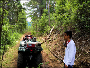
Photo Submitted 10/3/2016 (Thanks!)
ADD PHOTOS
TERRAIN
| Miles Of Trail | 17 | |
| Climate Type | Forest | |
| Elevation | 8500 to 9500 ft. | |
| Trail Maintenance | Marked, Not Rated, Lightly Maintained | |
| Loose Dirt |  Little Little | |
| Hard Pack |  Mostly Mostly | |
| Sand |  None None | |
| Mud | Little | |
| Dust | Little | |
| Rocks |  Some Some | |
| Trees |  Many Many | |
| Steep Hills | Some | |
| Water Crossings |  Few Few | |
| Small Jumps | None | |
| Large Jumps | None | |
| Berms | None | |
| Sand/Gravel Pits | None | |
| Single Track | None | |
| Roads | Some | |
| Shade | Some | |
| Hazards | Few | (hazards assumed marked but use caution) |
 Novice Novice | Little | |
 Amateur Amateur | Mostly | |
 Expert Expert | Some |
GPS POINTS


KEY SERVICES
 Gasoline Gasoline | 5-20 Miles (N) | Allsup's Convenience Store (575) 682-3072 |
| Diesel | 5-20 Miles (N) | Allsup's Convenience Store (575) 682-3072 |
 Water Water | Cloudcroft, NM | |
 RV Hookup RV Hookup | 5-20 Miles (N) | Sugar Pines Campground (575) 682-3375 |
 RV Disposal RV Disposal | 5-20 Miles (N) | Sugar Pines Campground (575) 682-3375 |
| Campground | 1-5 Miles (E) | Bluff Springs Campground (575) 682-2551 |
 Conv Store Conv Store | 5-20 Miles (N) | Allsup's Convenience Store (575) 682-3072 |
RIDER COMMENTS & REVIEWS