 |
      |
| Home > New Mexico > Greenie Peak |
Greenie Peak
Thursday, August 21, 2025
| Other Names | Carson National Forest, Questa Ranger District, Cabresto Canyon, Sawmill Mountain, Midnight Meadows |
| Last Known Status | Open |
This off-road trail system starts outside the town of Red River but eventually climbs the tallest peak in New Mexico, providing some spectacular views of snow capped mountains, mixed pine tree forests and open grassy meadows. The main trail is about 6 miles long each way but there is a side spur a short distance in for the Midnight Meadows trail.
The terrain is very rocky as you head up in elevation but eventually smooths out. The trail is rated as easy to moderate difficulty but can be narrow in some sections.
This is a popular destination due to the town being very ATV and UTV friendly. Bring a set of warm clothes as the temperature conditions can change quickly, even during the summer months.
REGULATIONS
| Permit Required | Yes | NM OHV Permit |
| Dates Open | Year-Round | |
| Other ATV Stickers Accepted | Yes | Residents of any state without an OHV registration program must purchase a Nonresident OHV Use Permit. (AK, AL, FL, GA, HI, IL, KS, KY, MS, NC, NE, OK, SC, SD, TN, VA, WV) |
| Spark Arrestor | Yes | A spark arresting exhaust silencer or end cap is required for all vehicles. |
| Noise Limit | Yes (96 dB) | |
| Whip Flags | Not Required | |
| Maximum Vehicle Width | No Restriction | |
 Motorcycles & Dirt Bikes Motorcycles & Dirt Bikes | Permitted | |
 ATVs ATVs | Permitted | |
 UTV & SXS UTV & SXS | Permitted | |
 SUVs & Jeeps (registered) SUVs & Jeeps (registered) | Permitted | |
| Dune Buggy & Sand Rail 4x4 (unregistered) | Permitted | |
| 2 Stroke Engines | No Restriction | |
 Camping Camping | Some Areas | (camp in developed sites only) |
 Campfires Campfires | ||
| Night Riding | Unknown | |
| Trail Blazing | Prohibited | riders must stay on trail |
| Rule Enforcement |
TYPE OF AREA
| Area | Motorized Trails |
| Land | National Forest |
FEES & PASSES
| Parking | (None) |
| Entry | (None) |
| Riding | (None) |
| Camping | (None) |
RATINGS
| Our Rating |  Good Good |
| Recommended Stay | Full Day |
| Comments | (Scroll Down For Rider Reviews & Comments) |
DRIVING DIRECTIONS
| Nearest City | Red River, NM | ||
| Address | Mallette Road, Red River, NM 87558 | ||
| From: Taos, NM
1) Take NM-522 North about 37 miles 2) Turn right (east) onto NM-38, continue 12.5 miles toward the town of Red River 3) Turn left (north) onto Mallette Road, continue 1.6 miles 4) Trailhead is on the right (north). |


OFFICIAL CONTACTS
| Contact Info | Carson National Forest - Questa Ranger District P.O. Box 110 Questa, NM 87556 (575) 586-0520 mailroom_r3_carson@fs.fed.us www.fs.usda.gov |
| Contact Info | New Mexico Game And Fish 1 Wildlife Way Santa Fe, NM 87507 (505) 476-8000 (888) 248-6866 ispa@state.nm.us wildlife.dgf.nm.gov |
Greenie Peak Trail Photo
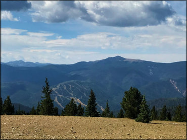
Photo Submitted 9/1/2020 (Thanks!)
ADD PHOTOS
TERRAIN
| Miles Of Trail | 12 | |
| Climate Type | Forest | |
| Elevation | 8650 to 11259 ft. | |
| Trail Maintenance | Marked, Not Rated, Lightly Maintained | trails are marked with brown carsonite posts |
| Loose Dirt |  Little Little | |
| Hard Pack |  Mostly Mostly | |
| Sand |  None None | |
| Mud | Little | |
| Dust | Little | |
| Rocks |  Some Some | |
| Trees |  Many Many | |
| Steep Hills | Many | |
| Water Crossings | None | |
| Small Jumps | None | |
| Large Jumps | None | |
| Berms | None | |
| Sand/Gravel Pits | None | |
| Single Track | None | |
| Roads | Some | |
| Shade | Some | |
| Hazards |  Few Few | (hazards assumed marked but use caution) |
 Novice Novice | Some | |
 Amateur Amateur | Mostly | |
 Expert Expert | Little |

KEY SERVICES
 Gasoline Gasoline | 1-5 Miles (S) | Diamond Shamrock (505) 754-6348 |
| Diesel | 1-5 Miles (SE) | Valero (575) 754-3284 |
 Water Water | 1-5 Miles (S) | Red River RV Park (575) 754-6187 |
 RV Hookup RV Hookup | 1-5 Miles (S) | Red River RV Park (575) 754-6187 |
 RV Disposal RV Disposal | 1-5 Miles (S) | Red River RV Park (575) 754-6187 |
| Campground | 1-5 Miles (SW) | Junebug Campground (575) 586-0520 |
 Conv Store Conv Store | 1-5 Miles (S) | Diamond Shamrock (505) 754-6348 |
RIDER COMMENTS & REVIEWS