 |
      |
| Home > North Carolina > Brown Mountain |
Brown Mountain OHV Trails
Tuesday, March 31, 2026
| Other Names | Pisgah National Forest, Parks Creek, Carroll Creek, Pearcey Creek, Lenoir, Grandfather Ranger District |
| Last Known Status | Open |
This popular off-road trail system offers about 34 miles of marked and maintained ATV and single track motorcycle trails with challenges ranging from easy to difficult with seasonal mud pits.
The main entrance road is RV accessible and the staging area offers ample parking opportunities. A trail pass is required but must be obtained in advance prior to entry. Nearby Craig Mountain Farm is located just past the main entrance and they sell the trail pass plus fresh produce, canned goods and local honey. Visitors can also contact the Grandfather Ranger District to get a current list of vendors that sell the pass.
Primitive camping is permitted but the area is very busy during the weekends.
Interestingly, nearby Brown Mountain has a mysterious reputation for unexplained light orbs which have been reported on moonless nights.
REGULATIONS
| Permit Required | Yes | Trail Pass |
| Dates Open | April 1 - January 1 | |
| Other ATV Stickers Accepted | Unknown | |
| Spark Arrestor | Yes | A spark arresting exhaust silencer or end cap is required for all vehicles. |
| Noise Limit | Yes (99 dB) | |
| Whip Flags | Not Required | |
| Maximum Vehicle Width | No Restriction | |
 Motorcycles & Dirt Bikes Motorcycles & Dirt Bikes | Permitted | |
 Four Wheelers Four Wheelers | Some Areas | permitted on designated ATV and 4x4 trails |
 UTV & SXS UTV & SXS | Some Areas | permitted on designated ATV and 4x4 trails |
 SUVs & Jeeps (registered) SUVs & Jeeps (registered) | Some Areas | permitted on Trail 8 and section of Trail 1 |
| Dune Buggy & Sand Rail 4x4 (unregistered) | Some Areas | permitted on Trail 8 and section of Trail 1 |
| 2 Stroke Engines | No Restriction | |
| MX Helmet Required | Yes | |
 Camping Camping | Some Areas | permitted alongside trail but not at trailhead |
 Campfires Campfires | Some Areas | (permitted in developed campsites only) |
| Night Riding | Unknown | |
| Trail Blazing | Prohibited | vehicles must stay on trail |
| Alcohol | Prohibited | |
| Rule Enforcement |
TERRAIN
| Approx Size | 8,320 acres (13 sq mi) | |
| Miles Of Trail | 34 | |
| Climate Type | Forest | |
| Elevation | 1100 to 2500 ft. | |
| Trail Maintenance | Marked, Rated, Lightly Maintained | trails are marked for one-way traffic |
| Loose Dirt |  Some Some | |
| Hard Pack | Some | |
| Sand |  Little Little | |
| Mud | Little | |
| Dust | Little | |
| Rocks | Some | some very technical rock climbs |
| Trees |  Many Many | |
| Steep Hills |  Few Few | |
| Water Crossings | Few | |
| Small Jumps | Few | |
| Large Jumps |  None None | |
| Berms | Some | |
| Sand/Gravel Pits | None | |
| Single Track | Some | |
| Roads | Some | |
| Intersections | Few | |
| Rider Traffic | Some | |
| Shade | Many | |
| Ranges/Gunfire | None | |
| Hazards | Few | (hazards are marked) |
 Novice Novice | Some | |
 Amateur Amateur |  Mostly Mostly | |
 Expert Expert | Some | some very technical and rocky 4x4 trails |
TYPE OF AREA
| Area | Motorized Trails |
| Land | National Forest |
GPS POINTS


KEY SERVICES
 Gasoline Gasoline | 5-20 Miles (S) | Oak Hill Grocery Store (828) 437-3810 |
| Diesel | 5-20 Miles (S) | Exxon (828) 437-1053 |
 Water Water | 5-20 Miles (N) | Mortimer Campground (828) 652-2144 |
 RV Hookup RV Hookup | 1-5 Miles (W) | Steel Creek Park and Campground (828) 433-5660 |
 RV Disposal RV Disposal | 1-5 Miles (W) | Steel Creek Park and Campground (828) 433-5660 |
| Campground | 5-20 Miles (N) | Mortimer Campground (828) 652-2144 |
 Conv Store Conv Store | 1-5 Miles (SW) | Craig Mountain Farm (828) 437-5003 |
FEES & PASSES
| Parking | (None) |
| Entry | (None) |
| Riding | Yes ($5.00 per rider) Season pass - $30 |
| Camping | (None) |
RATINGS
| Our Rating |  |
| Recommended Stay | Full Day |
| Comments | (Scroll Down For Rider Reviews & Comments) |
DRIVING DIRECTIONS
| Nearest City | Collettsville, NC | ||
| From: Hickory, NC
1) Take US-321 North towards the town of Lenoir, about 17 miles 2) Turn left (south) on N. Main Street, continue .3 miles 3) Turn right (west) on SR-90, continue about about 9 miles 4) Turn left (south) on Adako Road, continue about 4 miles 5) Turn right on FS 299. Continue towards the staging area. |


OFFICIAL CONTACTS
| Contact Info | Pisgah National Forest - Grandfather Ranger District 109 East Lawing Drive Nebo, NC 28761 (828) 652-2144 (828) 257-4200 mailroom_r8_north_carolina@fs.fed.us www.fs.usda.gov |
| Contact Info | Craig Mountain Farm 1547 Brown Mountain Beach Road Morganton, NC 28655 (828) 437-5003 siskbeth@bellsouth.net |
| Comment | sells trail pass |
Brown Mountain Trail Photo
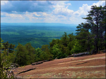
Ride your ATV or UTV to the top of the mountain and you will be rewarded with some great scenic views.
Brown Mountain Trail Photo
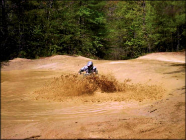
Just like anywhere, when it is wet there can be some deep puddles and mud holes as seen here.
Brown Mountain Trail Photo
There are trails open to ATVs, others for motorcycles or trails bikes and some for UTVs up to 65 inches, and a couple that support 4x4 vehicles also.
Brown Mountain Trail Photo
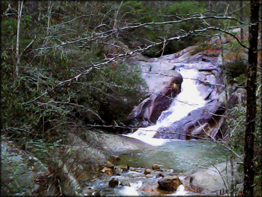
There is a small stream accessible from the ATV trail that forms a natural swimming hole.
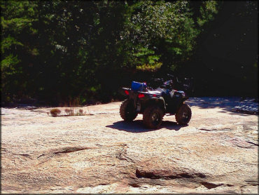
Brown Mountain Trail Photo
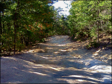
This trail is wide enough for UTVs up to 65 inches or more as well as 4x4s, but not all trails are this wide.
Brown Mountain Trail Photo
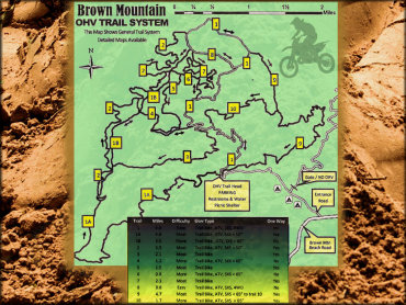
This is a rough map of the Brown Mountain trail system with some info about trail width and permitted vehicle types and widths.
Brown Mountain Trail Photo
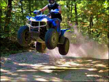
Found a spot on the trail to catch some air. Not bad.
Brown Mountain Trail Photo
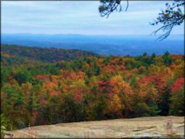
A view from the top of the mountain late in the season.
Brown Mountain Trail Photo
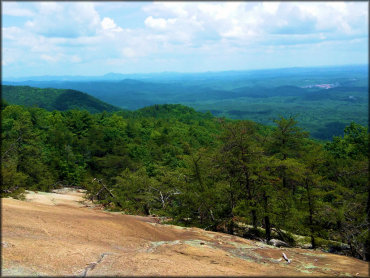
A view from a similar spot on the mountain taken during the summer.
Brown Mountain Trail Photo
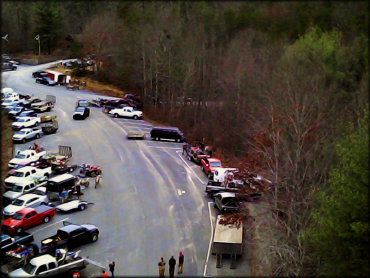
This is an aerial view of the staging area. It is paved and parking is tight and crowded. Recommended for pickup trucks and utility trailers but not large RVs.
RIDER COMMENTS & REVIEWS