 |
      |
| Home > Oklahoma > Soggy Bottom Trails |
Soggy Bottom Trails
Saturday, May 10, 2025
| Other Names | Canadian River, Wanette Byars Bridge, Grain Bin Pub |
| Last Known Status | Open |
Open to all off road vehicles, this private park borders Canadian River and offers 120 acres of 4x4 and ATV trails, a sand track plus some mud bog pits. The property also has direct river access, so bring the boats to round out a nice long weekend.
Recent improvements include an outdoor grain silo pub with deck and live bands/karaoke every Saturday night (small fee charged for cover for band, no charge for karaoke), clean restrooms with running hot and cold water and RV sites with water hookups (electric coming soon). Call before you haul.
REGULATIONS
| Permit Required | No | |
| Dates Open | Friday 2pm-2am, Saturday 9am-2am, Sunday 9am-2am. Monday through Thursday call for arrangements - (405) 765-9993. | |
| Spark Arrestor | No | A spark arresting exhaust silencer or end cap is not required but is always recommended. |
| Noise Limit | No | |
| Whip Flags | Not Required | |
| Maximum Vehicle Width | No Restriction | |
 Motorcycles & Dirt Bikes Motorcycles & Dirt Bikes | Permitted | |
 ATVs ATVs | Permitted | |
 UTV & SXS UTV & SXS | Permitted | |
 SUVs & Jeeps (registered) SUVs & Jeeps (registered) | Permitted | |
| Dune Buggy & Sand Rail 4x4 (unregistered) | Permitted | |
| 2 Stroke Engines | No Restriction | |
 Camping Camping | No Restriction | (camp anywhere) |
 Campfires Campfires | ||
| Night Riding | No | Day/night riding trails/river available 24/7. |
| Rule Enforcement | ||
| Comment | Canadian River access for any type of off-road riding, boats, airboats, hovercrafts, tubes, canoes, etc. | |
TERRAIN
| Approx Size | 120 acres | |
| Miles Of Trail | 20 | |
| Climate Type | Forest | |
| Elevation | 935 to 950 ft. | |
| Trail Maintenance | Unknown | |
| Loose Dirt |  Little Little | |
| Hard Pack | Little | |
| Sand |  Mostly Mostly | |
| Mud | Little | |
| Dust | Little | |
| Rocks | Little | |
| Trees |  Many Many | |
| Steep Hills |  None None | |
| Water Crossings | Many | |
| Small Jumps | None | |
| Large Jumps | None | |
| Berms | None | |
| Sand/Gravel Pits | None | |
| Single Track | None | |
| Roads |  Few Few | |
| Shade |  Some Some | |
| Hazards | Few | (hazards assumed marked but use caution) |
 Novice Novice | Some | |
 Amateur Amateur | Mostly | |
 Expert Expert | Little |
TYPE OF AREA
| Area | Motorized Trails, Forest, River, Sand |
| Land | Privately Owned / Commercial |
GPS POINTS
KEY SERVICES
 Gasoline Gasoline | 5-20 Miles (NE) | Kwick Stop (405) 784-2004 |
| Diesel | 5-20 Miles (NE) | Kwick Stop (405) 784-2004 |
 Water Water | On Site | |
 RV Hookup RV Hookup | Wanette, OK | coming soon |
 RV Disposal RV Disposal | Wanette, OK | coming soon |
| Campground | On Site | |
 Conv Store Conv Store | 5-20 Miles (NE) | Kwick Stop (405) 784-2004 |
FEES & PASSES
| Parking | (None) |
| Entry | Yes ($10.00 per person) Entrance fee for all other persons including passengers. Kids 10 and under are free. |
| Riding | (None) |
| Camping | Yes Tent: $10.00 RV: $25.00 Addtl. Vehicle: $0.00 RV primitive site - $20/night |
RATINGS
| Our Rating |  Good Good |
| Recommended Stay | Full Day |
| Comments | (Scroll Down For Rider Reviews & Comments) |
DRIVING DIRECTIONS
| Nearest City | Wanette, OK | ||
| Address | 44179 Drummond Road, Wanette, OK 74878 | ||
| From: Oklahoma City, OK
1) Take I-40 east to exit 178 2) Turn right (south) off the exit ramp onto Hwy 102, continue about 28 miles 3) Turn left (east) onto Hwy 39, continue .2 miles 4) Turn right (south) onto Hwy 102, continue 4.5 miles toward park entrance. |


OFFICIAL CONTACTS
| Contact Info | Soggy Bottom Trails 44179 Drummond Road Wanette, OK 74878 (405) 765-9993 soggybottomtrails@gmail.com www.soggybottomtrailsok.com |
Soggy Bottom Trails Photo
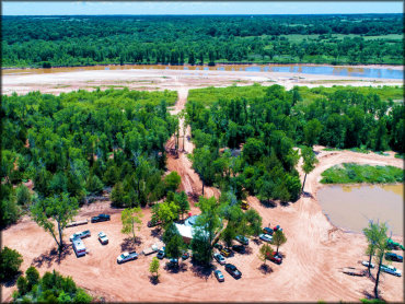
Photo Submitted 3/13/2019 (Thanks!)
Soggy Bottom Trails Photo
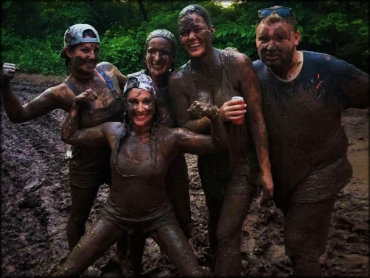
Photo Submitted 3/13/2019 (Thanks!)
Soggy Bottom Trails Photo
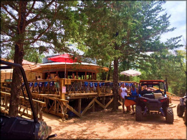
Photo Submitted 3/13/2019 (Thanks!)
Soggy Bottom Trails Photo
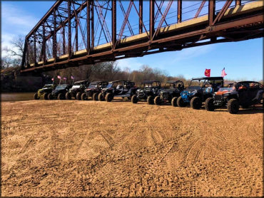
Photo Submitted 3/13/2019 (Thanks!)
Soggy Bottom Trails Photo
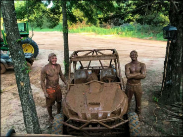
Photo Submitted 3/13/2019 (Thanks!)
Soggy Bottom Trails Photo

Photo Submitted 3/13/2019 (Thanks!)
Soggy Bottom Trails Photo
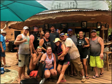
Photo Submitted 3/13/2019 (Thanks!)
Soggy Bottom Trails Photo
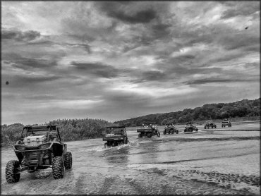
Photo Submitted 3/13/2019 (Thanks!)
RIDER COMMENTS & REVIEWS