 |
      |
| Home > Oregon > Edison Butte |
Edison Butte OHV Trail System
Tuesday, March 31, 2026
| Other Names | Deschutes National Forest, Mt. Bachelor, Sheridan Mountain, Kwolh Butte, Little Lake, Lava Lake, Tot Mountain |
| Last Known Status | Open |
This area offers miles of two way traffic trails that wind through a dense ponderosa pine and hemlock forest. The terrain consists mostly of loose chunk rock and lava ridges with some technical uphill and downhill climbs.
Sheridan Mountain and Kwohl Butte are two ski shelters to discover that provide scenic mountain views. The trail system is open to motorized use April 1 through November 30 but the best time to visit is between June through October.
Camping and parking space for large RVs or trailers can be found at the Edison Sno-Park parking lot.
REGULATIONS
| Permit Required | Yes | Oregon ATV Permit stickers required |
| Dates Open | April 1 - November 30 | |
| Other ATV Stickers Accepted | Yes | An operating permit issued for another state will be honored, but only if the issuing state also honors Oregon operating permits. (As of October 1, 2021, Oregon no longer honors stickers from Washington.) (AZ, CA, ID, IN, MO, NV, PA, SC, UT, VT) |
| Spark Arrestor | Yes | A spark arresting exhaust silencer or end cap is required for all vehicles. |
| Noise Limit | Yes (99 dB) | |
| Whip Flags | Not Required | |
| Maximum Vehicle Width | No Restriction | |
 Motorcycles & Dirt Bikes Motorcycles & Dirt Bikes | Permitted | |
 ATVs ATVs | Permitted | |
 UTV & SXS UTV & SXS | Permitted | |
 4x4 & Jeeps (registered) 4x4 & Jeeps (registered) | Permitted | |
| Dune Buggy & Sand Rail 4x4 (unregistered) | Permitted | Oregon ATV Permit stickers required |
| 2 Stroke Engines | No Restriction | |
| MX Helmet Required | Youth Only | required for persons under 18 by state law (RiderPlanet strongly recommends helmets for all riders.) |
 Camping Camping | No Restriction | (camp anywhere) |
 Campfires Campfires | ||
| Night Riding | Unknown | |
| Trail Blazing | Prohibited | stay on trails |
| Rule Enforcement |
TERRAIN
| Approx Size | 32,000 acres (50 sq mi) | |
| Miles Of Trail | 25 | |
| Climate Type | Forest | |
| Elevation | 5000 to 7200 ft. | |
| Trail Maintenance | Marked, Rated, Heavily Maintained | |
| Loose Dirt |  Some Some | |
| Hard Pack |  Mostly Mostly | |
| Sand |  None None | |
| Mud | Some | |
| Dust |  Little Little | |
| Rocks | Little | |
| Trees |  All All | |
| Single Track | Some | |
| Roads | Some | |
| Shade | All | |
| Hazards |  Few Few | (hazards assumed marked but use caution) |
 Novice Novice | Little | |
 Amateur Amateur | Mostly | |
 Expert Expert | Some |
TYPE OF AREA
| Area | Motorized Trails |
| Land | National Forest |


KEY SERVICES
 Gasoline Gasoline | 5-20 Miles (SE) | Crossroads Station (541) 593-8767 |
| Diesel | 5-20 Miles (SE) | Crossroads Station (541) 593-8767 |
 Water Water | 5-20 Miles (SE) | Snowy River RV Park (541) 593-2597 |
 RV Hookup RV Hookup | 5-20 Miles (SE) | Snowy River RV Park (541) 593-2597 |
 RV Disposal RV Disposal | 5-20 Miles (SE) | Snowy River RV Park (541) 593-2597 |
| Campground | On Site | |
 Conv Store Conv Store | 5-20 Miles (SE) | Crossroads Station (541) 593-8767 |
FEES & PASSES
| Parking | (None) |
| Entry | (None) |
| Riding | (None) |
| Camping | (None) |
RATINGS
| Our Rating |  Good Good |
| Recommended Stay | Full Day |
| Comments | (Scroll Down For Rider Reviews & Comments) |
DRIVING DIRECTIONS
| Nearest City | Bend, OR | ||
| From: Bend, OR
1) Take CR-46 West (Cascade Lakes Hwy) about 16 miles toward the Sunriver exit 2) Turn left (south) on NF-45 (Edison Ice Cave Road), continue about 4 miles 3) Look for the Edison Sno-Park parking signs, stage here. |

OFFICIAL CONTACTS
| Contact Info | Central Oregon OHV Operations (541) 383-4010 sm.fs.cohvops@usda.gov www.fs.usda.gov |
| Comment | 24-Hour OHV Trail Hotline |
| Contact Info | Deschutes National Forest - Bend / Fort Rock Ranger District 63095 Deschutes Market Road Bend, OR 97701 (541) 383-5300 sm.fs.bfr_fd@usda.gov www.fs.usda.gov |
| Contact Info | Oregon ATV Safety Education Card (877) 772-3359 atv.info@state.or.us www.oregon.gov |
| Contact Info | Oregon State Parks Online Store 725 Summer Street NE, Suite C Salem, OR 97301 (800) 551-6949 park.info@oregon.gov store.oregonstateparks.org |
Edison Butte Trail Photo
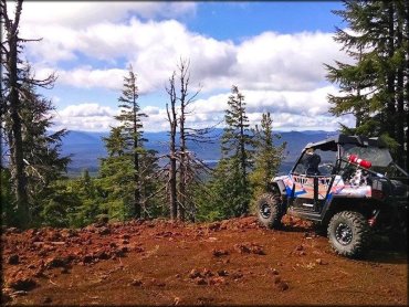
Photo Submitted 10/25/2014 (A great shot. Thanks!)
Edison Butte Trail Photo

Photo Submitted 2/24/2013 (Thanks!)
Edison Butte Trail Photo
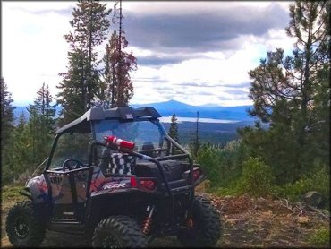
Photo Submitted 10/25/2014 (Thanks!)
Edison Butte Trail Photo
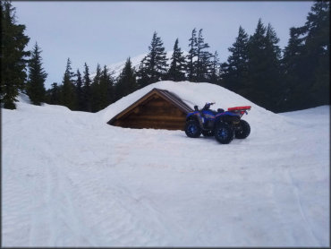
Photo Submitted 4/1/2022 (Thanks!)
RIDER COMMENTS & REVIEWS