 |
      |
| Home > Oregon > Winchester Trails |
Winchester Trails
Saturday, May 10, 2025
| Other Names | Coos County Forest, Bandon |
| Last Known Status | Open |
This trail system was once a real gem but some have told us that it is now somewhat in need of repair. The trails are mostly soft damp single track surrounded by thick vegetation but lack of funding may have caused some of them to deteriorate and you will likely encounter deep ruts, washouts and windfall.
The trails are numbered and most eventually loop back to the main road, however, there may also be some logging paths that cross over the trail multiple times, making it difficult to determine which is the path and which is the trail. Some of the trails are also covered with tree roots that get a little bit slick in the damp, humid climate.
A map of the area may still be posted on the kiosk sign at the trailhead, but no guarantees. These are multi-use trails, so watch for horses, bikers and hikers. If you have recent information about the status of this place be sure to let us know.
REGULATIONS
| Permit Required | Yes | Oregon ATV Permit stickers required Class III only! |
| Dates Open | Year-Round except during fire season (riding is discouraged during rainy season). Exact dates vary. | |
| Other ATV Stickers Accepted | Yes | An operating permit issued for another state will be honored, but only if the issuing state also honors Oregon operating permits. (As of October 1, 2021, Oregon no longer honors stickers from Washington.) (AZ, CA, ID, IN, MO, NV, PA, SC, UT, VT) |
| Spark Arrestor | Yes | A spark arresting exhaust silencer or end cap is required for all vehicles. |
| Noise Limit | Yes (99 dB) | Oregon ATV noise limits apply (all vehicles limit 99 dB) |
| Whip Flags | Not Required | |
| Maximum Vehicle Width | ||
 Motorcycles & Dirt Bikes Motorcycles & Dirt Bikes | Permitted | |
 ATVs ATVs | Some Areas | Not Recommended most trails are too NARROW - heed this warning |
 UTV & SXS UTV & SXS | Prohibited | |
 4x4 & Jeeps (registered) 4x4 & Jeeps (registered) | Prohibited | narrow trails |
| Dune Buggy & Sand Rail 4x4 (unregistered) | Prohibited | Oregon ATV Permit stickers required |
| 2 Stroke Engines | No Restriction | |
| MX Helmet Required | Youth Only | required for persons under 18 by state law (RiderPlanet strongly recommends helmets for all riders.) |
 Camping Camping | Prohibited | |
 Campfires Campfires | Prohibited | |
| Night Riding | Unknown | Not Recommended |
| Trail Blazing | Prohibited | vehicles must stay on trail |
| Alcohol | Some Areas | |
| Rule Enforcement | Few/Periodic | |
| Comment | when you see these trails - you'll want to obey every rule | |
TERRAIN
| Approx Size | 16,000 acres (25 sq mi) | |
| Miles Of Trail | 30 | |
| Climate Type | Coastal Forest - Humid, Damp | |
| Elevation | 300 to 350 ft. | |
| Trail Maintenance | Marked, Rated, Lightly Maintained | some trails have deteriorated due to lack of funding |
| Loose Dirt |  Mostly Mostly | |
| Hard Pack |  Some Some | |
| Sand |  Little Little | |
| Mud | Little | |
| Dust |  None None | climate is damp - no dust! |
| Rocks | Little | |
| Trees |  All All | many roots |
| Steep Hills | Some | |
| Water Crossings | Some | water crossings have bridges |
| Small Jumps |  Few Few | |
| Large Jumps | None | |
| Berms |  Many Many | |
| Sand/Gravel Pits | None | |
| Single Track | All | |
| Roads | Few | mostly single track |
| Intersections | Some | logging trails cross at some points, making it confusing |
| Rider Traffic | Some | |
| Shade | All | |
| Ranges/Gunfire | None | |
| Hazards | Few | (hazards not marked) lots of slippery tree roots |
 Novice Novice | Little | |
 Amateur Amateur | Mostly | |
 Expert Expert | Some |
TYPE OF AREA
| Area | Motorized Trails |
| Land | County Land, Coos County Forest Lands |
GPS POINTS


KEY SERVICES
 Gasoline Gasoline | 5-20 Miles (SW) | Shell (541) 347-9724 |
| Diesel | 5-20 Miles (SW) | Shell (541) 347-9724 |
 Water Water | 5-20 Miles (SW) | potable water Bullards Beach State Park (541) 347-2209 |
 RV Hookup RV Hookup | 5-20 Miles (SW) | Bandon RV Park (541) 347-4122 |
 RV Disposal RV Disposal | 5-20 Miles (SW) | Bandon RV Park (541) 347-4122 |
| Campground | 5-20 Miles (SW) | Bullards Beach State Park (541) 347-2209 |
 Conv Store Conv Store | 5-20 Miles (SW) | Wilsons Market (541) 347-3083 |
FEES & PASSES
| Parking | (None) |
| Entry | (None) |
| Riding | (None) |
| Camping | (None) |
RATINGS
| Pros | sometimes groomed, no dust, challenging, winding |
| Cons | tree roots make it slick, some trails confusing, humid, some trails closed for lack of maintenance |
| Our Rating |  Excellent Excellent |
| Recommended Stay | Full Day |
| Comments | (Scroll Down For Rider Reviews & Comments) |
DRIVING DIRECTIONS
| Nearest City | Coos Bay, OR | ||
| From: Coos Bay, OR
1) Take 101S to mile post #251 (before Bandon) 2) Trailhead is on the right (west). |


OFFICIAL CONTACTS
| Contact Info | Coos County Forestry Department 1309 West Central Coquille, OR 97423 (541) 396-7750 lmorgan@co.coos.or.us www.co.coos.or.us |
| Contact Info | Oregon Parks And Recreation Department (503) 986-0712 (800) 551-6949 park.info@oregon.gov www.oregon.gov |
| Contact Info | Oregon ATV Safety Education Card (877) 772-3359 atv.info@state.or.us www.oregon.gov |
| Contact Info | Oregon State Parks Online Store 725 Summer Street NE, Suite C Salem, OR 97301 (800) 551-6949 park.info@oregon.gov store.oregonstateparks.org |
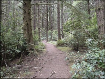
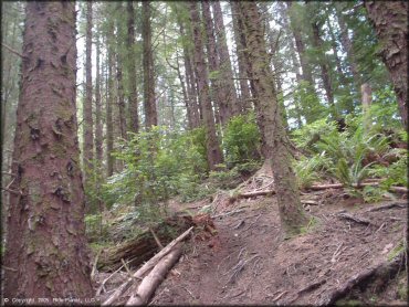
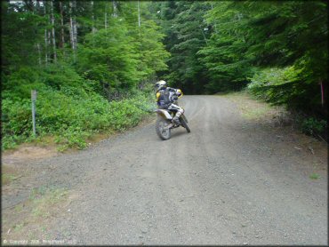
Winchester Trails Photo
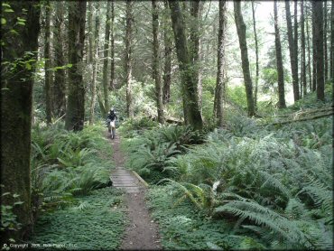
Trails like this make you want to keep coming back. There is plenty of singletrack and some technical stuff.
Winchester Trails Photo
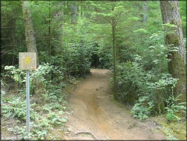
The trails are marked like this and additional details are available on the map at the trailhead kiosk.
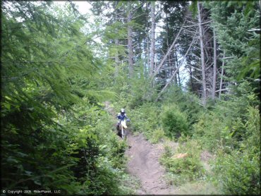
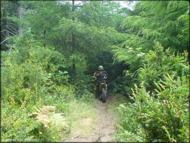
Winchester Trails Photo
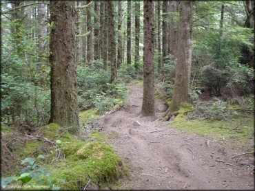
There are plenty of challenges and lots of fun twisty sections on these narrow woods trails.
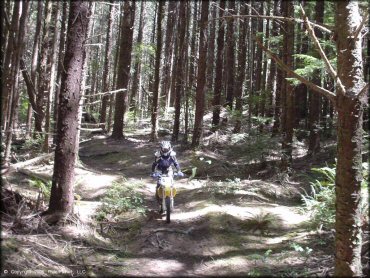
Winchester Trails Photo
It is easy to get disoriented with all of the twists and turns. A gps unit is only somewhat helpful, mostly to gather your bearings when you reach a clearing.
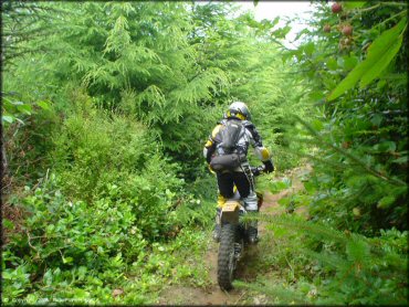
Winchester Trails Photo
Another thing to watch out for is the tree roots! If you haven't done a lot of Oregon trails riding before it may take some getting used to.
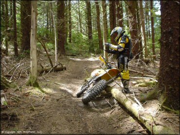
Winchester Trails Photo
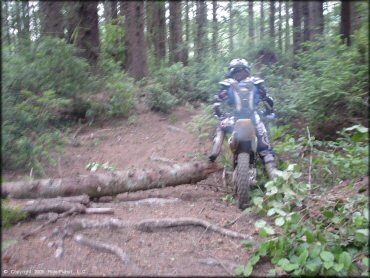
And of course expect to encounter some fallen trees at times, depending on recent weather and the current funding for trail maintenance.
Winchester Trails Photo
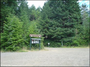
This is the main staging area which consists of a gravel parking lot and this trailhead kiosk.
Winchester Trails Photo
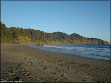
And the Oregon coast is right around the corner.
Winchester Trails Photo
Winchester Trails Photo
Winchester Trails Photo
Winchester Trails Photo
Winchester Trails Photo
Winchester Trails Photo
RIDER COMMENTS & REVIEWS