 |
      |
| Home > Pennsylvania > East Kettle |
East Kettle ATV Trail
Thursday, May 21, 2026
| Other Names | Bald Eagle ATV Trail, Mill Run Creek, Penns Creek Mountain, Furnace Run Creek, Hunter Road, Henstep Valley Trail, Union County, Snyder County, Bald Eagle State Forest, Jacks Mountain Trailhead |
| Last Known Status | Open |
This part of the Bald Eagle State Forest offers a long ATV loop that winds through a mixed hardwood forest. The staging area is located off of SR-235 which has level parking and an informational kiosk.
The main trail is rated as mostly easy but there are a couple side trails that are a little more challenging. The terrain is mostly hard packed dirt with occasional sections covered with crushed gravel.
Primitive camping is permitted throughout the forest but a permit is required which can be obtained by contacting the Bald Eagle State Forest. ATVs must be registered, have proof of liability insurance and be 58" or less in width. Motorcycles are not permitted.
REGULATIONS
| Permit Required | No | ATVs must be registered and have proof of liability insurance. |
| Dates Open | Friday before Memorial Day through last full weekend in September | |
| Other ATV Stickers Accepted | Yes | (AR, AZ, CA, CO, CT, DE, IA, ID, IN, LA, MA, ME, MI, MN, MO, MT, ND, NH, NJ, NM, NY, OH, OK, RI, UT, VT, WA, WI) |
| Spark Arrestor | Yes | A spark arresting exhaust silencer or end cap is required for all vehicles. |
| Noise Limit | Yes (99 dB) | |
| Whip Flags | Not Required | |
| Maximum Vehicle Width | Yes (58 inches) | has entrance gate or posts vehicles under 1200lbs dry weight and 58 inches wide permitted |
 Motorcycles & Dirt Bikes Motorcycles & Dirt Bikes | Prohibited | |
 ATVs ATVs | Permitted | (maximum width 58 inches) |
 UTV & SXS UTV & SXS | Permitted | (maximum width 58 inches) |
 SUVs & Jeeps (registered) SUVs & Jeeps (registered) | Prohibited | |
| Dune Buggy & Sand Rail 4x4 (unregistered) | Prohibited | |
| 2 Stroke Engines | No Restriction | |
| MX Helmet Required | Yes | helmets required by state law |
 Camping Camping | ||
 Campfires Campfires | ||
| Night Riding | Unknown | |
| Trail Blazing | Prohibited | stay on trails |
| Rule Enforcement |
TERRAIN
| Approx Size | 198,000 acres (309 sq mi) | |
| Miles Of Trail | 16 | |
| Climate Type | Forest | |
| Elevation | 1550 to 2000 ft. | |
| Trail Maintenance | Marked, Not Rated, Lightly Maintained | |
| Loose Dirt |  Little Little | |
| Hard Pack |  Mostly Mostly | |
| Sand |  None None | |
| Mud | Little | |
| Dust | Little | |
| Rocks |  Some Some | |
| Trees |  All All | |
| Steep Hills |  Few Few | |
| Water Crossings | None | |
| Small Jumps | None | |
| Large Jumps | None | |
| Berms | None | |
| Sand/Gravel Pits | None | |
| Single Track | None | |
| Roads | Few | |
| Shade |  Many Many | |
| Hazards | Few | (hazards assumed marked but use caution) |
 Novice Novice | Some | |
 Amateur Amateur | Mostly | |
 Expert Expert | Little |
TYPE OF AREA
| Area | Motorized Trails |
| Land | State Forest |

KEY SERVICES
 Gasoline Gasoline | 5-20 Miles (NE) | Sheetz (570) 966-1809 |
| Diesel | 5-20 Miles (NE) | Sheetz (570) 522-7438 |
 Water Water | 1-5 Miles (NW) | Penns Creek Campground (570) 922-1371 |
 RV Hookup RV Hookup | 1-5 Miles (NW) | Penns Creek Campground (570) 922-1371 |
 RV Disposal RV Disposal | 1-5 Miles (NW) | Penns Creek Campground (570) 922-1371 |
| Campground | 5-20 Miles (NW) | Cherry Run Primitive Campsite (570) 922-3344 |
 Conv Store Conv Store | 5-20 Miles (NE) | Harvey's Food Mart (570) 922-4662 |
FEES & PASSES
| Parking | (None) |
| Entry | (None) |
| Riding | (None) |
| Camping | (None) |
RATINGS
| Our Rating |  Good Good |
| Recommended Stay | Full Day |
| Comments | (Scroll Down For Rider Reviews & Comments) |
DRIVING DIRECTIONS
| Nearest City | Glen Iron, PA | ||
| From: Mifflinburg, PA
1) Take SR-45 West 6 miles 2) Turn left on Laurel Road, continue 2.5 miles (name changes to Cherry Run Road) 3) Turn left (south) on SR-235, continue .4 miles 4) Turn right (west) to stay on SR-235, continue 4 miles 5) Staging area is on the right (west). |


OFFICIAL CONTACTS
| Contact Info | Bald Eagle State Forest 18865 Old Turnpike Road Millmont, PA 17845 (570) 922-3344 fd07@pa.gov www.dcnr.pa.gov |
| Contact Info | Pennsylvania ATV Registration / Insurance Info P.O. Box 8553 Harrisburg, PA 17105-8553 (866) 545-2476 (717) 783-9227 ra-snowatv@pa.gov www.dcnr.pa.gov |
East Kettle Trail Photo
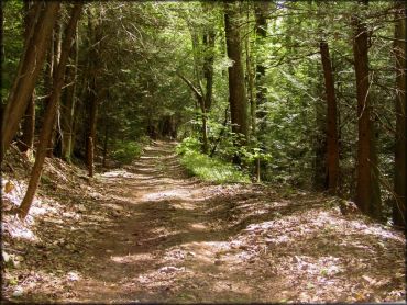
Photo Submitted 8/13/2015 (Thanks!)
East Kettle Trail Photo
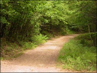
Photo Submitted 8/13/2015 (Thanks!)
East Kettle Trail Photo
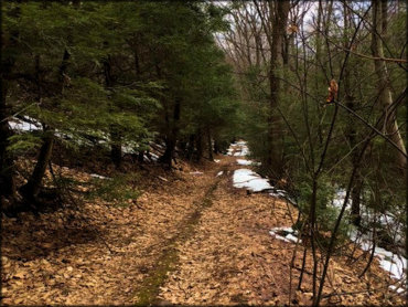
Photo Submitted 3/26/2017 (Thanks!)
East Kettle Trail Photo
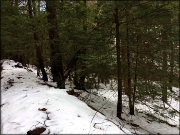
Photo Submitted 3/26/2017 (Thanks!)
RIDER COMMENTS & REVIEWS