 |
      |
| Home > Pennsylvania > Martin Hill |
Martin Hill ATV Trail
Thursday, May 21, 2026
| Other Names | Martin Hill, Buchanan State Forest, Blankley Road, Blankley Picnic Area, Cove Creek, Sweet Root Run Creek, Pigeonroost Gap, Sweetroot Natural Area, Sweet Root Road |
| Last Known Status | Open |
This part of the Buchanan State Forest has about 18 miles of ATV trails that go outside the boundaries of the Sweet Root Natural Area and Martin Hill Wild Area. The trails are marked and maintained and even have a few cool bridge crossings and interesting landmarks.
The trails are mostly old logging roads with some loose chunk rock and a few rocky hill climbs. There are several staging areas to choose with plenty of parking. Bobcats, wild turkey and deer can be occasionally seen. Nearby Shawnee State Park offers camping, several boat ramps and swimming beaches.
REGULATIONS
| Permit Required | No | ATVs must be registered and have proof of liability insurance. |
| Dates Open | Friday before Memorial Day through last full weekend in September | |
| Other ATV Stickers Accepted | Yes | (AR, AZ, CA, CO, CT, DE, IA, ID, IN, LA, MA, ME, MI, MN, MO, MT, ND, NH, NJ, NM, NY, OH, OK, RI, UT, VT, WA, WI) |
| Spark Arrestor | Yes | A spark arresting exhaust silencer or end cap is required for all vehicles. |
| Noise Limit | Yes (99 dB) | |
| Whip Flags | Not Required | |
| Maximum Vehicle Width | Yes (58 inches) | has entrance gate or posts vehicles under 1200lbs dry weight and 58 inches wide permitted |
 Motorcycles & Dirt Bikes Motorcycles & Dirt Bikes | Prohibited | |
 ATVs ATVs | Permitted | (maximum width 58 inches) |
 UTV & SXS UTV & SXS | Permitted | (maximum width 58 inches) |
 SUVs & Jeeps (registered) SUVs & Jeeps (registered) | Prohibited | |
| Dune Buggy & Sand Rail 4x4 (unregistered) | Prohibited | |
| 2 Stroke Engines | No Restriction | |
| MX Helmet Required | Yes | helmets required by state law |
 Camping Camping | No Restriction | (camp anywhere) |
 Campfires Campfires | ||
| Night Riding | Unknown | |
| Trail Blazing | Prohibited | stay on trails |
| Rule Enforcement |
TYPE OF AREA
| Area | Motorized Trails |
| Land | State Forest |
FEES & PASSES
| Parking | (None) |
| Entry | (None) |
| Riding | (None) |
| Camping | (None) |
RATINGS
| Our Rating |  |
| Recommended Stay | Full Day |
| Comments | (Scroll Down For Rider Reviews & Comments) |
DRIVING DIRECTIONS
| Nearest City | Rainsburg, PA | ||
| From: Bedford, PA
For 326 Staging Area: 1) Take Hwy 326 south about 10 miles 2) Staging area is on the left (east). For Refuge Trail Staging Area: 3) Turn west past the 326 Staging Area onto Blankley Road, continue about 2 miles 4) Veer right to stay on Blankley Road, continue .7 miles 5) Staging area is on the left (south). For Tower Road Staging Area: 6) Continue south about 2 miles past the intersection for Blankley Road (road name changes to Martin Hill Road) 7) Turn right (west) onto Tower Road, staging area is on the immediate left. |


OFFICIAL CONTACTS
| Contact Info | Buchanan State Forest 25185 Great Cove Road Mcconnelsburg, PA 17233 (717) 485-3148 fd02@pa.gov www.pa.gov |
| Contact Info | Pennsylvania ATV Registration / Insurance Info P.O. Box 8553 Harrisburg, PA 17105-8553 (866) 545-2476 (717) 783-9227 ra-snowatv@pa.gov www.pa.gov |
Martin Hill Trail Photo
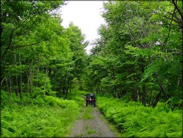
Photo Submitted 6/30/2015 (Thanks!)
Martin Hill Trail Photo
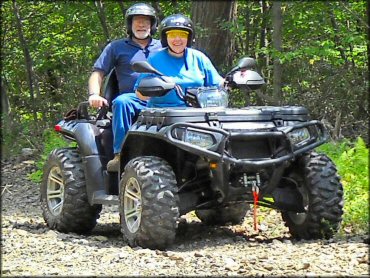
Photo Submitted 12/10/2012 (Thanks!)
ADD PHOTOS
TERRAIN
| Approx Size | 5,120 acres (8 sq mi) | |
| Miles Of Trail | 18 | |
| Climate Type | Forest | |
| Elevation | 2100 to 2500 ft. | |
| Trail Maintenance | Marked, Not Rated, Lightly Maintained | |
| Loose Dirt |  Little Little | |
| Hard Pack |  Mostly Mostly | |
| Sand |  None None | |
| Mud | Little | |
| Dust | Little | |
| Rocks |  Some Some | |
| Trees |  All All | |
| Steep Hills |  Few Few | |
| Water Crossings | None | |
| Small Jumps | None | |
| Large Jumps | None | |
| Berms | None | |
| Sand/Gravel Pits | None | |
| Single Track | None | |
| Roads | None | |
| Shade |  Many Many | |
| Hazards | Few | (hazards assumed marked but use caution) |
 Novice Novice | Some | |
 Amateur Amateur | Mostly | |
 Expert Expert | Little |
GPS POINTS


KEY SERVICES
 Gasoline Gasoline | 5-20 Miles (N) | Sheetz (814) 623-9392 |
| Diesel | 5-20 Miles (N) | Kwik Fill (814) 623-8002 |
 Water Water | 5-20 Miles (NW) | Friendship Village Campground and RV Park (814) 623-1677 |
 RV Hookup RV Hookup | 5-20 Miles (NW) | Friendship Village Campground and RV Park (814) 623-1677 |
 RV Disposal RV Disposal | 20-30 Miles (NW) | Shawnee State Park (814) 733-4218 |
| Campground | 20-30 Miles (NW) | Shawnee State Park (814) 733-4218 |
 Conv Store Conv Store | 5-20 Miles (N) | Sheetz (814) 623-9392 |
RIDER COMMENTS & REVIEWS