 |
      |
| Home > Pennsylvania > Sideling Hill |
Sideling Hill
Thursday, May 21, 2026
| Other Names | Wishart Swamp, Laurel Fork, Childers Ridge, Harbor Mountain, Wells Tannery, Buchanan State Forest |
| Last Known Status | Open |
This OHV area offers about 15 miles of trails with three staging areas. The terrain consists of semi-rocky hard packed trails with the occasional muddy section. Camping is permitted at the staging areas but a permit is required which can be obtained by contacting the Buchanan State Forest.
The staging areas on Cove Road are the least visited making them the most private. The trails are open to ATV use beginning the Friday before Memorial Day through the last full weekend in September. Vehicles must be 58 inches or less in width to ride on the trails. Dirt bikes and motorcycles are not permitted.
REGULATIONS
| Permit Required | No | ATVs must be registered and have proof of liability insurance. |
| Dates Open | Friday before Memorial Day through last full weekend in September | |
| Other ATV Stickers Accepted | Yes | (AR, AZ, CA, CO, CT, DE, IA, ID, IN, LA, MA, ME, MI, MN, MO, MT, ND, NH, NJ, NM, NY, OH, OK, RI, UT, VT, WA, WI) |
| Spark Arrestor | Yes | A spark arresting exhaust silencer or end cap is required for all vehicles. |
| Noise Limit | Yes (99 dB) | |
| Whip Flags | Not Required | |
| Maximum Vehicle Width | Yes (58 inches) | has entrance gate or posts vehicles under 1200lbs dry weight and 58 inches wide permitted |
 Motorcycles & Dirt Bikes Motorcycles & Dirt Bikes | Prohibited | |
 ATVs ATVs | Permitted | (maximum width 58 inches) |
 UTV & SXS UTV & SXS | Permitted | (maximum width 58 inches) |
 SUVs & Jeeps (registered) SUVs & Jeeps (registered) | Prohibited | |
| Dune Buggy & Sand Rail 4x4 (unregistered) | Prohibited | |
| 2 Stroke Engines | No Restriction | |
| MX Helmet Required | Yes | helmets required by state law |
 Camping Camping | Some Areas | camping permit required |
 Campfires Campfires | ||
| Night Riding | Unknown | |
| Trail Blazing | Prohibited | vehicles must stay on trail |
| Rule Enforcement |
TERRAIN
| Approx Size | 6,400 acres (10 sq mi) | |
| Miles Of Trail | 15 | |
| Climate Type | Forest | |
| Elevation | 1200 to 2000 ft. | |
| Trail Maintenance | Marked, Not Rated, Lightly Maintained | |
| Loose Dirt |  Little Little | |
| Hard Pack |  Mostly Mostly | |
| Sand |  None None | |
| Mud |  Some Some | |
| Dust | Little | |
| Rocks | Some | |
| Trees |  All All | |
| Steep Hills |  Few Few | |
| Small Jumps | None | |
| Large Jumps | None | |
| Berms | None | |
| Sand/Gravel Pits | None | |
| Single Track | None | |
| Hazards | Few | (hazards assumed marked but use caution) |
 Novice Novice | Some | |
 Amateur Amateur | Mostly | |
 Expert Expert | Little |
TYPE OF AREA
| Area | Motorized Trails |
| Land | State Forest |


KEY SERVICES
 Gasoline Gasoline | 5-20 Miles (SE) | Sideling Hill Service Plaza (717) 485-3226 |
| Diesel | 5-20 Miles (SE) | Sideling Hill Service Plaza (717) 485-3226 |
 Water Water | 20-30 Miles (W) | Friendship Village Campground (814) 623-1677 or (800) 992-3528 |
 RV Hookup RV Hookup | 20-30 Miles (W) | Friendship Village Campground (814) 623-1677 or (800) 992-3528 |
 RV Disposal RV Disposal | 5-20 Miles (SE) | Sideling Hill Service Plaza (717) 485-3226 |
| Campground | On Site | |
 Conv Store Conv Store | 5-20 Miles (SE) | Sideling Hill Service Plaza (717) 485-3226 |
FEES & PASSES
| Parking | (None) |
| Entry | (None) |
| Riding | (None) |
| Camping | (None) |
RATINGS
| Our Rating |  |
| Recommended Stay | Full Day |
| Comments | (Scroll Down For Rider Reviews & Comments) |
DRIVING DIRECTIONS
| Nearest City | Wells Tannery, PA | ||
| From: Bedford, PA
1) Take I-70 East to Exit 147 2) At base of ramp turn right on Lincoln Hwy (Hwy 30) 3) Follow Lincoln Hwy toward the town of Wells Tannery, about 11 miles 4) Turn left on Tannery Road 5) Continue about .3 miles 6) Turn left on Cove Road 7) Proceed about 1.5 miles to the parking area (at .3 miles veer right at fork). |


OFFICIAL CONTACTS
| Contact Info | Buchanan State Forest 440 Buchanan Trail Mcconnellsburg, PA 17233 (717) 485-3148 fd02@pa.gov www.dcnr.pa.gov |
| Contact Info | Pennsylvania ATV Registration / Insurance Info P.O. Box 8553 Harrisburg, PA 17105-8553 (866) 545-2476 (717) 783-9227 ra-snowatv@pa.gov www.dcnr.pa.gov |
Sideling Hill Trail Photo
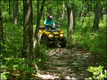
Photo Submitted 7/3/2012 (Great shot! Thank You.)
Sideling Hill Trail Photo
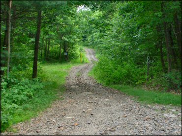
Photo Submitted 7/3/2012 (Thanks!)
Sideling Hill Trail Photo
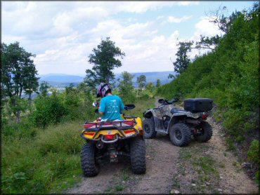
Photo Submitted 7/3/2012 (Thanks!)
Sideling Hill Trail Photo
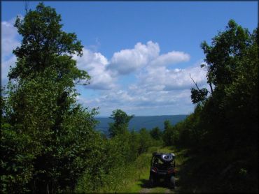
Photo Submitted 8/13/2015 (Thanks!)
RIDER COMMENTS & REVIEWS