 |
      |
| Home > South Carolina > Wambaw |
Wambaw Cycle Trail
Wednesday, August 20, 2025
| Other Names | Francis Marion National Forest, Wambah Swamp, Charleston County, Round Pond Cycle Trailhead |
| Last Known Status | Variable Schedule (Depends on daily conditions. Call (803) 561-4025 x 3 for recorded message.) |
About 40 miles of sandy ATV trail loops that wind through a scenic mixed pine and hardwood woodland can be found at this national forest. There are two main loops and the trails are open to dirt bikes and ATV vehicles under 50 inches in width. (Jeeps and other 4x4s are prohibited)
Round Pond Cycle Trailhead camping area is located off Halfway Creek Road and offers direct access to the trail system. The trail is open year-round but will close temporarily on short notice due to inclement weather, so check the hotline before heading out.
This trail system is activley maintained by the Wambaw Trail Riders so be sure to say thanks for all their hard work.
REGULATIONS
| Permit Required | No | |
| Dates Open | Open daily, weather permitting. Call first for current conditions - (803) 561-4025 x 3. | |
| Other ATV Stickers Accepted | Unknown | |
| Spark Arrestor | Yes | A spark arresting exhaust silencer or end cap is required for all vehicles. |
| Noise Limit | Yes | |
| Whip Flags | Not Required | |
| Maximum Vehicle Width | Yes (50 inches) | has entrance gate or posts |
 Motorcycles & Dirt Bikes Motorcycles & Dirt Bikes | Permitted | |
 Four Wheelers Four Wheelers | Permitted | (maximum width 50 inches) |
 UTV & SXS UTV & SXS | Permitted | (maximum width 50 inches) |
 SUVs & Jeeps (registered) SUVs & Jeeps (registered) | Prohibited | |
| Dune Buggy & Sand Rail 4x4 (unregistered) | Prohibited | |
| 2 Stroke Engines | No Restriction | |
| MX Helmet Required | Yes | |
 Camping Camping | Some Areas | (camp in developed sites only) |
 Campfires Campfires | ||
| Night Riding | Yes | machines must have lights |
| Trail Blazing | Prohibited | keep on designated trails |
| Rule Enforcement |
TERRAIN
| Approx Size | 9,600 acres (15 sq mi) | |
| Miles Of Trail | 40 | |
| Climate Type | Forest | |
| Elevation | 20 to 65 ft. | |
| Trail Maintenance | Marked, Not Rated, Heavily Maintained | |
| Loose Dirt |  Some Some | |
| Hard Pack |  None None | |
| Sand |  Mostly Mostly | |
| Mud |  Little Little | |
| Dust | Little | |
| Rocks | None | |
| Trees |  Many Many | |
| Steep Hills | None | |
| Water Crossings | None | |
| Small Jumps | None | |
| Large Jumps | None | |
| Berms | Many | |
| Sand/Gravel Pits | None | |
| Single Track | Many | |
| Roads | None | |
| Hazards |  Few Few | (hazards assumed marked but use caution) |
 Novice Novice | Some | |
 Amateur Amateur | Mostly | |
 Expert Expert | Little |
TYPE OF AREA
| Area | Motorized Trails |
| Land | National Forest |
GPS POINTS


KEY SERVICES
 Gasoline Gasoline | 5-20 Miles (SE) | Kangaroo Express (843) 887-3977 |
| Diesel | 5-20 Miles (SE) | Exxon (843) 887-3788 |
 Water Water | 5-20 Miles (S) | Mount Pleasant / Charleston KOA (843) 849-5177 |
 RV Hookup RV Hookup | 20-30 Miles (S) | Mount Pleasant / Charleston KOA (843) 849-5177 |
 RV Disposal RV Disposal | 20-30 Miles (S) | Mount Pleasant / Charleston KOA (843) 849-5177 |
| Campground | On Site | |
 Conv Store Conv Store | 5-20 Miles (SE) | BJ's Mini Mart (843) 520-4410 |
FEES & PASSES
| Parking | (None) |
| Entry | (None) |
| Riding | Yes ($5.00 per OHV) Annual passes can be purchased for $50. |
| Camping | (None) |
RATINGS
| Our Rating |  |
| Recommended Stay | Full Day |
| Comments | (Scroll Down For Rider Reviews & Comments) |
DRIVING DIRECTIONS
| Nearest City | Jamestown, SC | ||
| Address | Halfway Creek Road, Jamestown, SC 29453 | ||
| From: Mount Pleasant, SC
1) Take US-17 (US-701) north about 20 miles 2) Turn left (west) on Steed Creek Road, continue 4.5 miles 3) Turn right on Halfway Creek Road, continue 5.7 miles 4) Veer left at fork, continue about 1 mile. 5) Staging area is on the left. |


OFFICIAL CONTACTS
| Contact Info | OHV Trail Hotline (803) 561-4025 www.fs.usda.gov |
| Comment | Extension 3 |
| Contact Info | Francis Marion National Forest - Francis Marion Ranger District 2967 Steed Creek Road Hunger, SC 29450 (843) 336-2200 sm.fs.fmrd@usda.gov www.fs.usda.gov |
| Contact Info | Wambaw Trail Riders (803) 561-4025 wambawtrailriders@gmail.com |
Wambaw Trail Photo
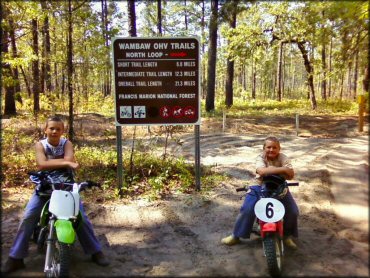
Photo Submitted 4/21/2012 (Thanks!)
Wambaw Trail Photo
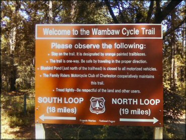
Photo Submitted 4/21/2012 (Thanks!)
Wambaw Trail Photo
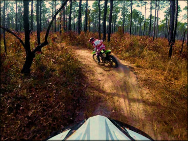
Photo Submitted 12/10/2017 (Thanks!)
Wambaw Trail Photo

Photo Submitted 2/23/2015 (Thanks!)
Wambaw Trail Photo
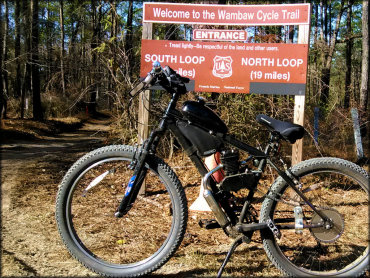
Photo Submitted 4/15/2017 (Thanks!)
RIDER COMMENTS & REVIEWS