 |
      |
| Home > Tennessee > Doe Mountain |
Doe Mountain Recreation Area
Saturday, May 10, 2025
| Other Names | Harbin Branch, Chimney Rock |
| Last Known Status | Open |
This off-road area has about 60+ miles of multiple-use trails that wind through heavily wooded mountains and rolling hills with scenic vistas. The trails are mostly hard packed and smooth, making it a good choice for beginners or those just looking for a relaxing ride. There are some single track trails but the terrain is narrow, rugged and steep, and is geared for experienced riders.
The trails are open daily, year-round from sunrise to sunset except during major holidays. The trailhead office is open from 8:30am-4:30pm but the gates are locked at 6pm. There is no fee charged to park at the trailhead office but a trail permit is required, which can be purchased online. Overnight parking is not permitted at the main office but camping with direct trail access can be found at R and D Campground. Cabin and lake house rentals can be found about 10 miles away. Guided ATV tours and rentals can be arranged by contacting Appalachians Outdoor Adventures.
Recent improvements include rebuilding Trail 15 back in October 2017 which provides access to Pioneer Village Shopping Center (near Mountain City). This town has multiple restaurants and a Marathon fuel station conveniently located near the trail.
REGULATIONS
| Permit Required | Yes | Doe Mountain Recreation Pass |
| Dates Open | Daily 8:30am-6pm | |
| Other ATV Stickers Accepted | Unknown | |
| Spark Arrestor | Yes | A spark arresting exhaust silencer or end cap is required for all vehicles. |
| Noise Limit | Yes (96 dB) | |
| Whip Flags | Not Required | |
| Maximum Vehicle Width | No Restriction | |
 Motorcycles & Dirt Bikes Motorcycles & Dirt Bikes | Permitted | |
 Four Wheelers Four Wheelers | Permitted | |
 UTV & SXS UTV & SXS | Permitted | |
 SUVs & Jeeps (registered) SUVs & Jeeps (registered) | Prohibited | |
| Dune Buggy & Sand Rail 4x4 (unregistered) | Prohibited | |
| 2 Stroke Engines | No Restriction | |
| MX Helmet Required | Yes | |
 Camping Camping | Prohibited | |
 Campfires Campfires | Prohibited | |
| Night Riding | No | trails are open daily from sunrise to sunset |
| Trail Blazing | Prohibited | stay on trail |
| Rule Enforcement |
TERRAIN
| Approx Size | 8,600 acres (13 sq mi) | |
| Miles Of Trail | 60 | |
| Climate Type | Forest | |
| Elevation | 2700 to 3889 ft. | |
| Trail Maintenance | Marked, Rated, Lightly Maintained | |
| Loose Dirt |  Little Little | |
| Hard Pack |  Mostly Mostly | |
| Sand |  None None | |
| Mud | Little | |
| Dust | Little | |
| Rocks | Little | |
| Trees |  All All | |
| Steep Hills |  Few Few | |
| Water Crossings | Few | |
| Small Jumps | None | |
| Large Jumps | None | |
| Berms | Few | |
| Sand/Gravel Pits | None | |
| Single Track |  Some Some | |
| Roads | Mostly | |
| Shade |  Many Many | |
| Hazards | Few | (hazards assumed marked but use caution) |
 Novice Novice | Some | |
 Amateur Amateur | Mostly | |
 Expert Expert | Little |
TYPE OF AREA
| Area | Motorized Trails |
| Land | State Forest |
GPS POINTS


KEY SERVICES
 Gasoline Gasoline | 1-5 Miles (W) | Exxon (423) 727-6589 |
| Diesel | 1-5 Miles (NE) | Exxon (423) 727-9522 |
 Water Water | 1-5 Miles (SW) | Roan Creek Campground (423) 768-0012 |
 RV Hookup RV Hookup | 1-5 Miles (SW) | Roan Creek Campground (423) 768-0012 |
 RV Disposal RV Disposal | 1-5 Miles (SW) | Roan Creek Campground (423) 768-0012 |
| Campground | 1-5 Miles (SW) | Roan Creek Campground (423) 768-0012 |
 Conv Store Conv Store | 1-5 Miles (W) | Exxon (423) 727-6589 |
FEES & PASSES
| Parking | (None) |
| Entry | Yes ($5.00 per person) day passenger permit |
| Riding | Yes ($25.00 per rider) Annual Pass - $60 |
| Camping | (None) |
RATINGS
| Our Rating |  Good Good |
| Recommended Stay | Full Day |
| Comments | (Scroll Down For Rider Reviews & Comments) |
DRIVING DIRECTIONS
| Nearest City | Mountain City, TN | ||
| Address | 1203 Harbin Hill Road, Mountain City, TN 37863 | ||
| From: Johnson City, TN
1) Take US-321 East about 7 miles 2) Turn right (south) onto TN-37/US-19, continue 5 miles 3) Turn left (east) onto TN-67, US-321, continue 25 miles 4) Turn right (south) onto Harbin Hill Road, continue about 1 mile toward park entrance. |


OFFICIAL CONTACTS
| Contact Info | Doe Mountain Visitor Center 1203 Harbin Hill Road Mountain City, TN 37863 (423) 460-1295 doemtntn@gmail.com doetn.com |
| Contact Info | Roan Creek Campground 205 Morefield Road Butler, TN 37640 (423) 768-0012 donna@roancreekcampground.com www.roancreekcampground.com |
| Contact Info | Creekside Chalet Log Cabin Rentals (423) 768-2446 ironmountaininn@gmail.com |
| Comment | cabin rentals |
| Contact Info | R&D Campground 900 Mining Town Road Mountain City, TN 37683 (423) 534-4804 randdcampground@gmail.com randdcampground.com |
| Contact Info | Appalachians Outdoor Adventures (828) 297-1289 appoutdooradventures@yahoo.com appalachiansoutdooradventures.com |
| Comment | Guided ATV tours and rentals. |
Doe Mountain Trail Photo
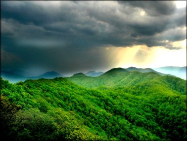
The views from the top of Kettlefoot FireTower offer some stunning views of the Roan Creek Valley. Photo Submitted 1/22/2014 (Thanks!)
Doe Mountain Trail Photo
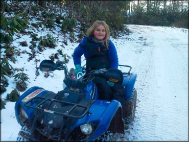
The trails are open daily, year-round. Photo Submitted 2/1/2015 (Thanks!)
Doe Mountain Trail Photo
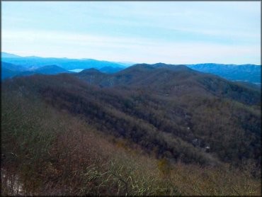
The rolling hills and Roan Creek Valley can be seen from the top of Doe Mountain. Photo Submitted 2/1/2015 (Thanks!)
Doe Mountain Trail Photo
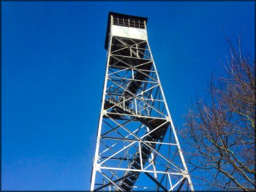
The Kettlefoot Fire Tower is located at the top of Doe Mountain. The tower is 60 feet high and has about 100 steps. Photo Submitted 2/1/2015 (Thanks!)
Doe Mountain Trail Photo

From the top of Kettlefoot Fire Tower you can even see North Carolina. Photo Submitted 6/10/2014 (Thanks!)
Doe Mountain Trail Photo

The Kettlefoot Fire Tower offers breathtaking views of the surrounding valleys. Photo Submitted 6/10/2014 (Thanks!)
RIDER COMMENTS & REVIEWS