 |
      |
| Home > Utah > Taylor Fork |
Taylor Fork
Sunday, May 31, 2026
| Other Names | Cedar Hollow ATV Trail, Shingle Creek ATV Campground, Uinta Wasatch Cache National Forest, Kamas Ranger District, Rileys Canyon, Beaver Creek, Castle Peak, Lower Provo River |
| Last Known Status | Open |
This popular trail system consists of two designated loops, the Cedar Loop and Beaver Creek. Both Taylor Forks and Shingle Creek Campground offer direct access to the ATV trails. There are no RV hookups but Shingle Creek Campground has potable water. The best time to visit is late summer.
REGULATIONS
| Permit Required | Yes | UT OHV Sticker |
| Dates Open | June - October | |
| Other ATV Stickers Accepted | No | Non-residents must purchase a non-resident OHV permit. |
| Spark Arrestor | Yes | A spark arresting exhaust silencer or end cap is required for all vehicles. |
| Noise Limit | Yes | |
| Whip Flags | Not Required | |
| Maximum Vehicle Width | Yes (50 inches) | |
 Motorcycles & Dirt Bikes Motorcycles & Dirt Bikes | Permitted | |
 ATVs ATVs | Permitted | (maximum width 50 inches) |
 UTV & SXS UTV & SXS | Permitted | (maximum width 50 inches) |
 SUVs & Jeeps (registered) SUVs & Jeeps (registered) | Prohibited | |
| Dune Buggy & Sand Rail 4x4 (unregistered) | Prohibited | |
| 2 Stroke Engines | No Restriction | |
 Camping Camping | Some Areas | (camp in developed sites only) |
 Campfires Campfires | Some Areas | (permitted in developed campsites only) |
| Night Riding | Unknown | |
| Trail Blazing | Prohibited | no trailblazing |
| Rule Enforcement |
Advertisement
TYPE OF AREA
| Area | Motorized Trails |
| Land | National Forest |
FEES & PASSES
| Parking | Yes ($3.00) |
| Entry | (None) |
| Riding | (None) |
| Camping | Yes Tent: $21.73 RV: $21.73 Addtl. Vehicle: $0.00 Taylor Fork Campground Fee - $21.73/night; Shingle Creek Campground - $21.73/night |
RATINGS
| Our Rating |  Very Good Very Good |
| Recommended Stay | 1-2 Days |
| Comments | (Scroll Down For Rider Reviews & Comments) |
DRIVING DIRECTIONS
| Nearest City | Heber City, UT | ||
| From: Salt Lake City, UT
1) Take I-80 East to Exit 148 2) Merge onto US-40 south, continue to Exit 4 3) Turn left (east) off the exit ramp onto SR-248, continue 11.4 miles 4) Turn left (north) onto SR-32/Main Street, continue .2 miles 5) Turn right (east) onto SR-150, continue about 10 miles 6) Campground entrance is on the right (south). |

OFFICIAL CONTACTS
| Contact Info | Uinta Wasatch Cache National Forest - Kamas Ranger District 50 E. Center Street Kamas, UT 84036 (435) 783-4338 mailroom_r4_uinta@fs.fed.us www.fs.usda.gov |
| Contact Info | Utah State Parks OHV Education Office 1594 W North Temple, Suite 116 Salt Lake City, UT 84116 (800) 648-7433 ohveducation@utah.gov recreation.utah.gov |
Taylor Fork Trail Photo
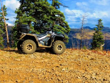
Photo Submitted 1/31/2016 (Thanks!)
ADD PHOTOS
TERRAIN
| Miles Of Trail | 25 | |
| Climate Type | Forest | |
| Elevation | 7350 to 8500 ft. | |
| Trail Maintenance | Marked, Not Rated, Lightly Maintained | |
| Loose Dirt |  Little Little | |
| Hard Pack |  Mostly Mostly | |
| Sand |  None None | |
| Mud | Little | |
| Dust | Little | |
| Rocks |  Some Some | |
| Trees |  All All | |
| Steep Hills | Some | |
| Small Jumps | None | |
| Large Jumps | None | |
| Berms |  Few Few | |
| Sand/Gravel Pits | None | |
| Single Track | None | |
| Roads | Few | |
| Shade |  Many Many | |
| Hazards | Few | (hazards assumed marked but use caution) |
 Novice Novice | Little | |
 Amateur Amateur | Mostly | |
 Expert Expert | Some |


KEY SERVICES
 Gasoline Gasoline | 5-20 Miles (W) | 7-11 (435) 783-4359 |
| Diesel | 5-20 Miles (W) | 7-11 (435) 783-4359 |
 Water Water | On Site | Shingle Creek Campground (435) 783-4338 |
 RV Hookup RV Hookup | 20-30 Miles (SW) | Knotty Pine Resort (435) 783-4349 |
 RV Disposal RV Disposal | 20-30 Miles (SW) | Knotty Pine Resort (435) 783-4349 |
| Campground | On Site | Taylor Fork and Shingle Creek Campground (435) 783-4338 |
 Conv Store Conv Store | 5-20 Miles (W) | 7-11 (435) 783-4359 |
RIDER COMMENTS & REVIEWS