 |
      |
| Home > Utah > Sand Flats |
Sand Flats Recreation Area
Friday, August 22, 2025
| Other Names | Moab, Slickrock Trail, Slick Rock Trail, Hells Revenge 4x4 Trail, Colorado Plateau, La Sal Mountains, Negro Bill, Grand County, Porcupine Trail, Fins and Things Trail |
| Last Known Status | Open |
Open year round, this off road mecca is home to the world Slickrock, Hell's Revenge, Porcupine Rim and Fins and Things 4x4 trails. Terrain mainly consists of petrified sand dunes known as Navajo Sandstone, and trails are geared for the more advanced rider or driver due to steep inclines and descents, rocky and off camber sections.
Camping is not permitted but there are nine designated campgrounds with over 120 sites and two group campgrounds nearby. For a quick dip check out the Mill Creek Canyon swimming hole.
REGULATIONS
| Permit Required | Yes | UT OHV Sticker |
| Dates Open | Year-Round | |
| Other ATV Stickers Accepted | No | Non-residents must purchase a non-resident OHV permit. |
| Spark Arrestor | Yes | A spark arresting exhaust silencer or end cap is required for all vehicles. |
| Noise Limit | Yes | |
| Whip Flags | Not Required | |
| Maximum Vehicle Width | ||
 Motorcycles & Dirt Bikes Motorcycles & Dirt Bikes | Some Areas | |
 ATVs ATVs | Some Areas | not permitted on the Slickrock Bike Trail |
 UTV & SXS UTV & SXS | Some Areas | not permitted on the Slickrock Bike Trail |
 SUVs & Jeeps (registered) SUVs & Jeeps (registered) | Some Areas | permitted on Fins & Things, Porcupine Rim & Hells Revenge Trails |
| Dune Buggy & Sand Rail 4x4 (unregistered) | Some Areas | permitted on Fins & Things, Porcupine Rim & Hells Revenge Trails |
| 2 Stroke Engines | Some Areas | |
| MX Helmet Required | Youth Only | required for persons under 18 by state law (RiderPlanet strongly recommends helmets for all riders.) |
 Camping Camping | Some Areas | (camp in developed sites only) |
 Campfires Campfires | Some Areas | (permitted in developed campsites only) |
| Night Riding | Yes | must have working headlights and taillights |
| Trail Blazing | Prohibited | keep vehicle on trail |
| Rule Enforcement | ||
| Comment | No specific decibel limit but excessive mechanical noise is prohibited. | |
TERRAIN
| Approx Size | 9,000 acres (14 sq mi) | |
| Miles Of Trail | 40 | |
| Climate Type | Desert | |
| Elevation | 4600 to 6000 ft. | |
| Trail Maintenance | Marked, Not Rated, Lightly Maintained | |
| Hard Pack |  Mostly Mostly | |
| Rocks |  Some Some | |
| Trees |  Few Few | |
| Steep Hills |  Many Many | |
| Small Jumps |  None None | |
| Large Jumps | None | |
| Single Track | Many | |
| Intersections | Many | |
| Rider Traffic | Many | |
| Ranges/Gunfire | None | |
| Hazards | Few | (hazards assumed marked but use caution) |
 Novice Novice |  Little Little | |
 Amateur Amateur | Mostly | |
 Expert Expert | Some |
TYPE OF AREA
| Area | Motorized Trails |
| Land | BLM, County Land, Grand County |
GPS POINTS


KEY SERVICES
 Gasoline Gasoline | 1-5 Miles (W) | Chevron (435) 259-0500 |
| Diesel | 1-5 Miles (W) | Chevron (435) 259-0500 |
 Water Water | 1-5 Miles (W) | Canyonlands Campground (435) 259-6848 |
 RV Hookup RV Hookup | 1-5 Miles (W) | Canyonlands Campground (435) 259-6848 |
 RV Disposal RV Disposal | 1-5 Miles (W) | Canyonlands Campground (435) 259-6848 |
| Campground | On Site | |
 Conv Store Conv Store | 1-5 Miles (W) | Chevron (435) 259-0500 |
FEES & PASSES
| Parking | (None) |
| Entry | Yes ($5.00 per vehicle) if entering park via bicycle or motorcycle cost is $2 |
| Riding | (None) |
| Camping | Yes Tent: $15.00 RV: $15.00 Addtl. Vehicle: $2.00 |
RATINGS
| Our Rating |  Very Good Very Good |
| Recommended Stay | 1-2 Days |
| Comments | (Scroll Down For Rider Reviews & Comments) |
DRIVING DIRECTIONS
| Nearest City | Moab, UT | ||
| From: Moab, UT
1) Take US-191 south about 1 mile 2) Turn left (north) on Mill Creek Drive, continue 1.4 miles 3) Turn right (east) on Sand Flats Road, continue about 2 miles toward park entrance. |

OFFICIAL CONTACTS
| Contact Info | BLM - Moab Field Office 82 East Dogwood Moab, UT 84532 (435) 259-2100 utmbmail@blm.gov www.blm.gov |
| Contact Info | Sand Flats Receation Area 125 E. Center Street Moab, UT 84532 (435) 259-2444 sfra@grand.utah.gov www.grandcountyutah.net |
| Comment | reservations for group campsites |
| Contact Info | Utah State Parks OHV Education Office 1594 W North Temple, Suite 116 Salt Lake City, UT 84116 (800) 648-7433 ohveducation@utah.gov recreation.utah.gov |
| Comment | OHV Permit Info |
Sand Flats Trail Photo
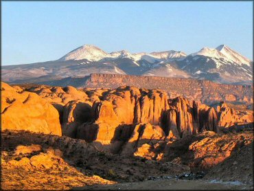
Photo Submitted 6/18/2012 (Thanks!)
Sand Flats Trail Photo
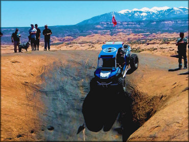
Photo Submitted 3/12/2020 (Thanks!)
Sand Flats Trail Photo
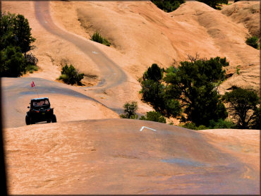
Photo Submitted 3/12/2020 (Thanks!)
Sand Flats Trail Photo
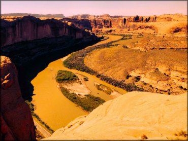
Photo Submitted 12/26/2014 (Thanks!)
Sand Flats Trail Photo
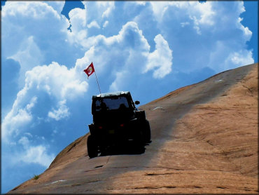
Photo Submitted 3/12/2020 (Thanks!)
Sand Flats Trail Photo
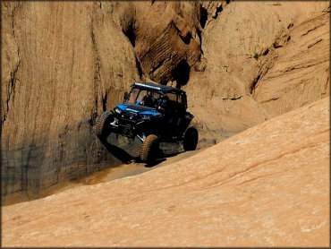
Photo Submitted 3/12/2020 (Thanks!)
Sand Flats Trail Photo
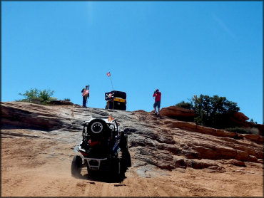
Photo Submitted 3/12/2020 (Thanks!)
Sand Flats Trail Photo
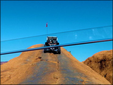
Photo Submitted 3/12/2020 (Thanks!)
Sand Flats Trail Photo
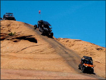
Photo Submitted 3/12/2020 (Thanks!)
Sand Flats Trail Photo
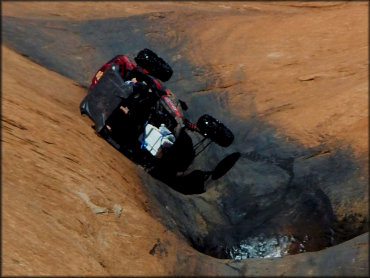
Photo Submitted 3/12/2020 (Thanks!)
RIDER COMMENTS & REVIEWS