 |
      |
| Home > Utah > Dome Plateau |
Dome Plateau
Friday, August 22, 2025
| Other Names | Colorado River, Dewey Bridge, Cave Springs, Laboco Arch, Professor Valley, Fisher Tower, Onion Creek, La Sal Mountains, Owl Draw Road, Dewey Bridge Campground |
| Last Known Status | Open |
This scenic area offers a long 4x4 loop that provides panoramic views of the surrounding desert and valleys. The trail winds near large caves, old mines and abandoned cabins made out of old railroad ties.
The trail can be accessed just after the Dewey Bridge or about 4 miles north. The terrain is mostly hardpacked, sandy and rocks, making this a good choice to bring the Jeep or ATV.
Primitive camping is permitted but there is a designated campground located near Dewey Bridge. The campground has seven sites that are available on a first come, first serve bases and can accommodate small RVs.
REGULATIONS
| Permit Required | Yes | UT OHV Sticker |
| Dates Open | Year-Round | |
| Other ATV Stickers Accepted | No | Non-residents must purchase a non-resident OHV permit. |
| Spark Arrestor | Yes | A spark arresting exhaust silencer or end cap is required for all vehicles. |
| Noise Limit | Yes | |
| Whip Flags | Not Required | |
| Maximum Vehicle Width | No Restriction | |
 Motorcycles & Dirt Bikes Motorcycles & Dirt Bikes | Permitted | |
 ATVs ATVs | Permitted | |
 UTV & SXS UTV & SXS | Permitted | |
 SUVs & Jeeps (registered) SUVs & Jeeps (registered) | Permitted | |
| Dune Buggy & Sand Rail 4x4 (unregistered) | Permitted | |
| 2 Stroke Engines | No Restriction | |
| MX Helmet Required | Youth Only | required for persons under 18 by state law (RiderPlanet strongly recommends helmets for all riders.) |
 Camping Camping | No Restriction | (camp anywhere) |
 Campfires Campfires | ||
| Night Riding | Unknown | |
| Trail Blazing | Prohibited | stay on the trail |
| Rule Enforcement |
TERRAIN
| Miles Of Trail | 50 | |
| Climate Type | Desert | |
| Elevation | 4200 to 5200 ft. | |
| Trail Maintenance | Marked, Not Rated, Lightly Maintained | many trails are not marked |
| Loose Dirt |  Little Little | |
| Hard Pack |  Mostly Mostly | |
| Sand |  Some Some | |
| Mud |  None None | |
| Dust | Some | |
| Rocks | Some | |
| Trees |  Few Few | |
| Steep Hills | Some | |
| Water Crossings | None | |
| Small Jumps | None | |
| Large Jumps | None | |
| Berms | None | |
| Sand/Gravel Pits | None | |
| Single Track | None | |
| Roads | Mostly | |
| Shade | Few | |
| Hazards | Few | (hazards assumed marked but use caution) has a couple dangerous dropoffs |
 Novice Novice | Some | |
 Amateur Amateur | Mostly | |
 Expert Expert | Little |
TYPE OF AREA
| Area | Motorized Trails |
| Land | BLM |


KEY SERVICES
 Gasoline Gasoline | 20-30 Miles (SW) | Maverik Adventure's First Stop (435) 259-0775 |
| Diesel | 20-30 Miles (SW) | Maverik Adventure's First Stop (435) 259-0775 |
 Water Water | 20-30 Miles (SW) | Moab RV Park and Campground (435) 259-4469 |
 RV Hookup RV Hookup | 20-30 Miles (SW) | Moab RV Park and Campground (435) 259-4469 |
 RV Disposal RV Disposal | 20-30 Miles (SW) | Moab RV Park and Campground (435) 259-4469 |
| Campground | 1-5 Miles (W) | Dewey Bridge Campground (435) 259-2100 |
 Conv Store Conv Store | 20-30 Miles (SW) | Maverik Adventure's First Stop (435) 259-0775 |
FEES & PASSES
| Parking | (None) |
| Entry | (None) |
| Riding | (None) |
| Camping | Yes Tent: $15.00 RV: $15.00 Addtl. Vehicle: $0.00 Dewey Bridge Campground Fee |
RATINGS
| Our Rating |  Very Good Very Good |
| Recommended Stay | Full Day |
| Comments | (Scroll Down For Rider Reviews & Comments) |
DRIVING DIRECTIONS
| Nearest City | Moab, UT | ||
| From: Moab, UT
1) Take US-128 north about 30 miles 2) Staging area is located just past the Dewy Bridge on the right (east). Alternate Staging Area: 3) Continue north about 4.5 miles 4) Look for a large DOT gravel pit on the left (west), turn here. |

OFFICIAL CONTACTS
| Contact Info | BLM - Moab Field Office 82 East Dogwood Moab, UT 84532 (435) 259-2100 utmbmail@blm.gov www.blm.gov |
| Contact Info | Utah State Parks OHV Education Office 1594 W North Temple, Suite 116 Salt Lake City, UT 84116 (800) 648-7433 ohveducation@utah.gov recreation.utah.gov |
Dome Plateau Trail Photo
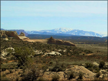
Photo Submitted 2/24/2017 (Thanks!)
Dome Plateau Trail Photo
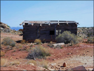
Photo Submitted 2/24/2017 (Thanks!)
Dome Plateau Trail Photo
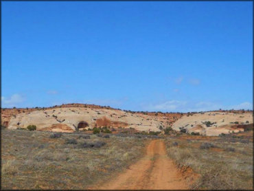
Photo Submitted 2/24/2017 (Thanks!)
Dome Plateau Trail Photo
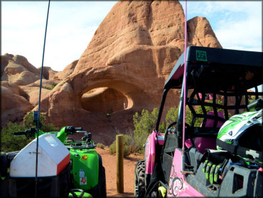
Photo Submitted 3/27/2016 (Thanks!)
Dome Plateau Trail Photo
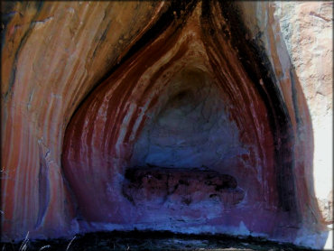
Photo Submitted 2/24/2017 (Thanks!)
Dome Plateau Trail Photo
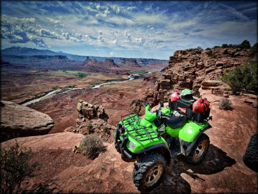
Photo Submitted 3/27/2016 (Thanks!)
Dome Plateau Trail Photo
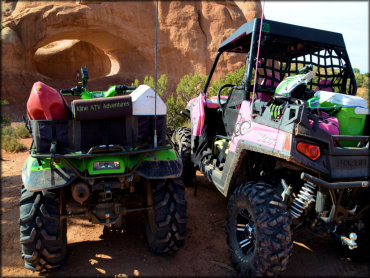
Photo Submitted 3/27/2016 (Thanks!)
RIDER COMMENTS & REVIEWS