 |
      |
| Home > Utah > Outlaw ATV Trail |
Outlaw ATV Trail
Thursday, April 30, 2026
| Other Names | Ashley National Forest, Vernal Ranger District, East Park Reservoir, Oaks Park Reservoir, Cart Creek, Big Lake, Little Brush Creek, Taylor Mountain, Dyer Mountain, Uinta Mountains, Trout Creek Peak, Kaler Hollow Campground |
| Last Known Status | Open |
This 38-mile long loop offers ATV riders a wide variety of terrain and difficulty that ranges from smooth and hardpacked gravel and dirt roads that wind through rolling hills and grassy meadows to chunky and steep mountain climbs. The trail winds through a scenic mixed pine and aspen forest with panoramic mountain views.
There are several designated trailheads and campgrounds that offer direct trail access. Most of the campgrounds are free except for East Park but note there is no running water at any of the sites so come prepared.
REGULATIONS
| Permit Required | Yes | UT OHV sticker required |
| Dates Open | May 1 - September 30 | |
| Other ATV Stickers Accepted | No | Non-residents must purchase a non-resident OHV permit. |
| Spark Arrestor | Yes | A spark arresting exhaust silencer or end cap is required for all vehicles. |
| Noise Limit | Yes (96 dB) | |
| Whip Flags | Not Required | |
| Maximum Vehicle Width | Yes (50 inches) | has entrance gate or posts |
 Motorcycles & Dirt Bikes Motorcycles & Dirt Bikes | Permitted | |
 ATVs ATVs | Permitted | (maximum width 50 inches) |
 UTV & SXS UTV & SXS | Permitted | (maximum width 50 inches) |
 SUVs & Jeeps (registered) SUVs & Jeeps (registered) | Some Areas | permitted on forest service roads |
| Dune Buggy & Sand Rail 4x4 (unregistered) | Some Areas | (maximum width 50 inches) permitted on forest service roads |
| 2 Stroke Engines | No Restriction | |
| MX Helmet Required | Youth Only | required for persons under 18 by state law (RiderPlanet strongly recommends helmets for all riders.) |
 Camping Camping | Some Areas | (camp in developed sites only) |
 Campfires Campfires | Some Areas | (permitted in developed campsites only) |
| Night Riding | Yes | |
| Trail Blazing | Prohibited | keep vehicle on trail |
| Rule Enforcement |
TYPE OF AREA
| Area | Motorized Trails |
| Land | National Forest |
FEES & PASSES
| Parking | (None) |
| Entry | (None) |
| Riding | (None) |
| Camping | Yes Tent: $12.00 RV: $12.00 Addtl. Vehicle: $0.00 East Park Campground Fee |
RATINGS
| Our Rating |  Good Good |
| Recommended Stay | Full Day |
| Comments | (Scroll Down For Rider Reviews & Comments) |
DRIVING DIRECTIONS
| Nearest City | Vernal, UT | ||
| From: Vernal, UT
For McKee Road Trailhead: 1) Take Hwy 191 North about 26 miles 2) Turn right (east) onto Forest Service Road 253/McKee Road, staging area is on the right. For Cart Creek Road Trailhead: 3) Continue north on Hwy 191 past McKee Road about 2 miles 4) Turn left (west) onto Forest Service Road 62/Cart Creek Road, continue about .25 miles 5) Staging area is on the right (north). |

OFFICIAL CONTACTS
| Contact Info | Ashley National Forest - Vernal Ranger District 355 North Vernal Avenue Vernal, UT 84078 (435) 789-1181 mailroom_r4_ashley@fs.fed.us www.fs.usda.gov |
Outlaw ATV Trail Photo
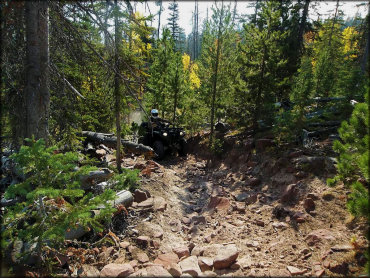
Photo Submitted 4/28/2017 (Thanks!)
ADD PHOTOS
TERRAIN
| Approx Size | 64,000 acres (100 sq mi) | |
| Miles Of Trail | 38 | |
| Climate Type | Forest | |
| Elevation | 8000 to 9500 ft. | |
| Trail Maintenance | Marked, Not Rated, Lightly Maintained | |
| Loose Dirt |  Little Little | |
| Hard Pack |  Mostly Mostly | |
| Sand |  None None | |
| Mud | Little | |
| Dust |  Some Some | |
| Rocks | Some | |
| Trees |  Many Many | |
| Steep Hills |  Few Few | |
| Water Crossings | Few | |
| Small Jumps | None | |
| Large Jumps | None | |
| Berms | Few | |
| Sand/Gravel Pits | None | |
| Single Track | None | |
| Roads | Few | |
| Shade | Some | |
| Hazards | Few | (hazards assumed marked but use caution) |
 Novice Novice | Mostly | |
 Amateur Amateur | Some | |
 Expert Expert | Little |
GPS POINTS

KEY SERVICES
 Gasoline Gasoline | 30+ Miles (N) | Conoco (215) 236-5395 |
| Diesel | 30+ Miles (N) | Conoco (215) 236-5395 |
 Water Water | 20-30 Miles (S) | Steinaker Campground (435) 789-4475 |
 RV Hookup RV Hookup | 20-30 Miles (S) | Steinaker Campground (435) 789-4475 |
 RV Disposal RV Disposal | 20-30 Miles (S) | Steinaker Campground (435) 789-4475 |
| Campground | 20-30 Miles (S) | Steinaker Campground (435) 789-4475 |
 Conv Store Conv Store | 30+ Miles (N) | Conoco (215) 236-5395 |
RIDER COMMENTS & REVIEWS