 |
      |
| Home > Utah > Sanpitch OHV Trail |
Sanpitch OHV Trail
Friday, August 22, 2025
| Other Names | Manti-la Sal National Forest, Maple Canyon, Log Canyon, Log Maple Canyon Loop, Sanpete Valley, Wasatch Plateau |
| Last Known Status | Open |
This trail system offers a 26 mile long loop that begins outside the town of Fountain Green, Utah. The trail eventually heads northwest into Log Canyon and evenually descends into Maple Canyon.
This area offers beautiful forest scenery and nicely maintained trails. Most of the terrain is rated as easy and there are no width restrictions, making this a perfect place for the wider machines.
Dispersed camping is permitted throughout the forest but Maple Canyon Campground offers 15 sites with standard amenities and potable water. Reservations are recommended but visitors should note that this is primarily a tent campground but a group site is available that can accomodate trailers up to 35 feet.
This trail is open year-round but the ATV riding season begins July 1 through mid October. For spectacular fall foliage visit this area around September 20 through October 10.
REGULATIONS
| Permit Required | Yes | UT OHV Sticker |
| Dates Open | July 1 - October 15 (to avoid snow) | |
| Other ATV Stickers Accepted | No | Non-residents must purchase a non-resident OHV permit. |
| Spark Arrestor | Yes | A spark arresting exhaust silencer or end cap is required for all vehicles. |
| Noise Limit | Yes (96 dB) | |
| Whip Flags | Not Required | |
| Maximum Vehicle Width | No Restriction | |
 Motorcycles & Dirt Bikes Motorcycles & Dirt Bikes | Permitted | |
 ATVs ATVs | Permitted | |
 UTV & SXS UTV & SXS | Permitted | |
 SUVs & Jeeps (registered) SUVs & Jeeps (registered) | Permitted | |
| Dune Buggy & Sand Rail 4x4 (unregistered) | Permitted | |
| 2 Stroke Engines | No Restriction | |
| MX Helmet Required | Youth Only | required for persons under 18 by state law (RiderPlanet strongly recommends helmets for all riders.) |
 Camping Camping | Some Areas | (camp in developed sites only) |
 Campfires Campfires | Some Areas | (permitted in developed campsites only) |
| Night Riding | Yes | |
| Trail Blazing | Prohibited | stay on trail |
| Rule Enforcement |
TERRAIN
| Approx Size | 350,000 acres (547 sq mi) | |
| Miles Of Trail | 26 | |
| Climate Type | Forest | |
| Elevation | 5692 to 9332 ft. | |
| Trail Maintenance | Marked, Rated, Lightly Maintained | |
| Loose Dirt |  Little Little | |
| Hard Pack |  Mostly Mostly | |
| Sand |  None None | |
| Mud | Little | |
| Dust | Little | |
| Rocks |  Some Some | |
| Trees |  All All | |
| Steep Hills |  Few Few | |
| Water Crossings | None | |
| Small Jumps | None | |
| Large Jumps | None | |
| Berms | Few | |
| Sand/Gravel Pits | None | |
| Single Track | None | |
| Roads | Some | |
| Intersections | Few | |
| Rider Traffic | Some | |
| Shade | All | |
| Hazards | Few | (hazards assumed marked but use caution) |
 Novice Novice | Mostly | |
 Amateur Amateur | Little | |
 Expert Expert | None | |
| Comment | Main trail is 26 mile loop, including valley travel back to your vehicle. About 50 miles if you include side trails. | |
TYPE OF AREA
| Area | Motorized Trails |
| Land | National Forest |
GPS POINTS


KEY SERVICES
 Gasoline Gasoline | 1-5 Miles (SE) | Conoco (435) 436-8631 |
| Diesel | 1-5 Miles (SE) | Conoco (435) 436-8631 |
 Water Water | On Site | Maple Canyon Campground (435) 637-2817 |
 RV Hookup RV Hookup | 30+ Miles (S) | Palisade State Park (435) 835-7275 |
 RV Disposal RV Disposal | 20-30 Miles (NE) | Millers Travel Center (435) 427-3315 |
| Campground | On Site | Maple Canyon Campground (435) 637-2817 |
 Conv Store Conv Store | 1-5 Miles (SE) | Conoco (435) 436-8631 |
FEES & PASSES
| Parking | (None) |
| Entry | (None) |
| Riding | (None) |
| Camping | Yes Tent: $10.00 RV: $10.00 Addtl. Vehicle: $0.00 Maple Canyon Campground Fee |
RATINGS
| Our Rating |  Good Good |
| Recommended Stay | Full Day |
| Comments | (Scroll Down For Rider Reviews & Comments) |
DRIVING DIRECTIONS
| Nearest City | Fountain Green, UT | ||
| Address | Log Canyon, Fountain Green, UT 84632 | ||
| From: Provo, UT
1) Take I-15 South to Exit 225 2) Turn left (east) onto Hwy 132, continue 13.7 miles 3) Turn right (west) onto W 400 Street, continue .4 miles 4) Veer left (south) onto West Side Road, continue about 5 miles 5) Turn right (west) onto South Freedom Road, continue .5 miles 6) Turn right (north) onto FR066, continue 1.5 miles 7) Staging area is on the right (north). For Maple Canyon Campground continue west about 1.5 miles. |

OFFICIAL CONTACTS
| Contact Info | Manti-la Sal National Forest 599 West Price River Drive Price, UT 84501 (435) 637-2817 mailroom_r4_manti_lasal@fs.fed.us www.fs.usda.gov |
| Contact Info | Sanpete County Travel Office P.O. Box 148 Manti, UT 84642 (435) 835-4321 kevin@sanpete.com www.utahatvtrails.org |
Sanpitch OHV Trail Photo
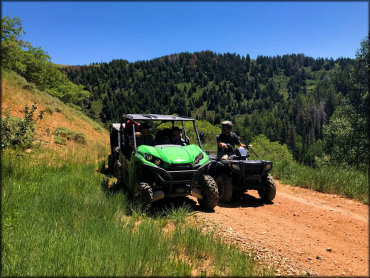
Photo Submitted 3/20/2019 (Thanks!)
Sanpitch OHV Trail Photo
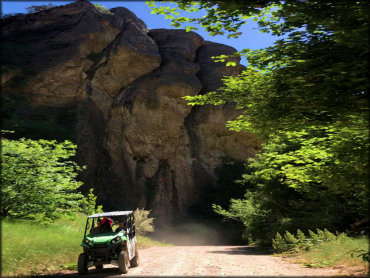
Photo Submitted 3/20/2019 (Thanks!)
Sanpitch OHV Trail Photo
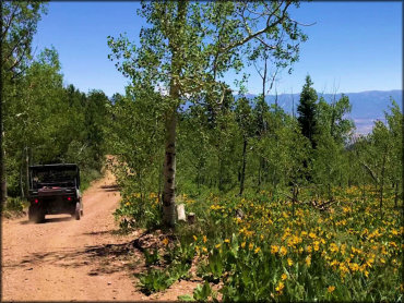
Photo Submitted 3/20/2019 (Thanks!)
Sanpitch OHV Trail Photo
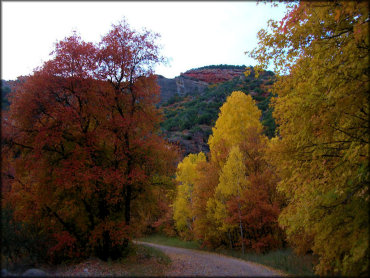
Photo Submitted 3/20/2019 (Thanks!)
RIDER COMMENTS & REVIEWS